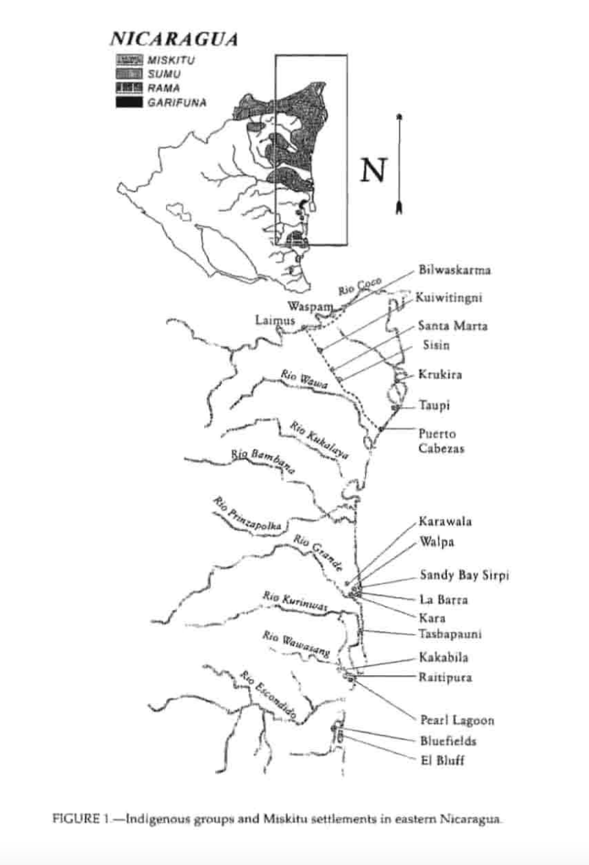
Dispossesions in the Americas

Dispossesions in the Americas

  • Inicio
  • Explorar
  • Autores
  • Sobre
  • Arte
  • Cuerpos
  • Planes de Estudio
  • Herencia Cultural
  • Mapas
  • Territorios
Volver a Explorar

Leyendo en Inglés

Mapa 1990

Indigenous groups and Miskitu settlements in eastern Nicaragua.

  • COE AND ANDERSON

Publicado: 1997

  • Descargar Imágen
  • Descargar Imágen
Mapa 1990

Indigenous groups and Miskitu settlements in eastern Nicaragua.

  • COE AND ANDERSON

Publicado: 1997

  • Descargar Imágen

Pueblos

  • MISKITU
  • SUMU
  • RAMA
  • GARIFUNA

Citas

Figure 1: Indigenous groups and Miskitu settlements in eastern Nicaragua. Coe;Felix and Gregory Anderson.1997."Ethnobotany of the Miskitu in Eastern Nicaragua." Journal of Ethnobotany 17(2):171-214. https://ethnobiology.org/sites/default/files/pdfs/JoE/17-2/CoeAnderson1997.pdf

  • Descargar Imágen

Artículos Relacionados

Carta de la Costa de Mosquitos;con sus islas;cayos;bancos y bajos adyacentes entre dicha y la Isla de Jamayca

Carta de la Costa de Mosquitos;con sus islas;cayos;bancos y bajos adyacentes entre dicha y la Isla de Jamayca

Mapa 1767 - 1781
REGIÓN FRONTERA SUR

REGIÓN FRONTERA SUR

Mapa 2000
Haec pars Peruvianae, regiones Chicam & Chile[nsem]
     complectitur, & Regionem

Haec pars Peruvianae, regiones Chicam & Chile[nsem] complectitur, & Regionem

Mapa 1551
MAPA DE SANTA MARÍA CUPILA

MAPA DE SANTA MARÍA CUPILA

Mapa 1500 - 1599
PRESENT-DAY MAYA LANGUAGE BOUNDARIES OF GUATEMALA

PRESENT-DAY MAYA LANGUAGE BOUNDARIES OF GUATEMALA

Mapa 1961
THE ARGENTINE REPUBLIC;CHILE;PARAGUAY AND URUGUAY

THE ARGENTINE REPUBLIC;CHILE;PARAGUAY AND URUGUAY

Mapa 1887
Detail from the 1770 copy of Francisco Álvarez Barreiro’s 1728 map of northern New Spain illustrating Spanish mapping of Indian domains in southern Texas and along the Gulf Coast, especially through the repetition of labels: “tierra de los Pampopas,” “tierra de los Carrizos,” “tierra de los Cujanes,” etc.

Detail from the 1770 copy of Francisco Álvarez Barreiro’s 1728 map of northern New Spain illustrating Spanish mapping of Indian domains in southern Texas and along the Gulf Coast, especially through the repetition of labels: “tierra de los Pampopas,” “tierra de los Carrizos,” “tierra de los Cujanes,” etc.

Mapa 1728
FAMILIAS LINGUISTICAS Y LENGUAS INDIGENAS - SEGUNDA REGION: SUR ANDINO

FAMILIAS LINGUISTICAS Y LENGUAS INDIGENAS - SEGUNDA REGION: SUR ANDINO

Mapa 1989

Despojos en las Américas

Un Proyecto de

University of Pennsylvania

Copyright 2024

Con el apoyo de

Mellon Foundation

Diseño y Desarrollo del Sitio

Element 84

Créditos Artísticos

Figure 1: Indigenous groups and Miskitu settlements in eastern Nicaragua. Coe;Felix and Gregory Anderson.1997.“Ethnobotany of the Miskitu in Eastern Nicaragua.” Journal of Ethnobotany 17(2):171-214. https://ethnobiology.org/sites/default/files/pdfs/JoE/17-2/CoeAnderson1997.pdf

Páginas del Sitio

  • Inicio
  • Explorar
  • Autores
  • Sobre
  • Arte
  • Cuerpos
  • Planes de Estudio
  • Herencia Cultural
  • Mapas
  • Territorios