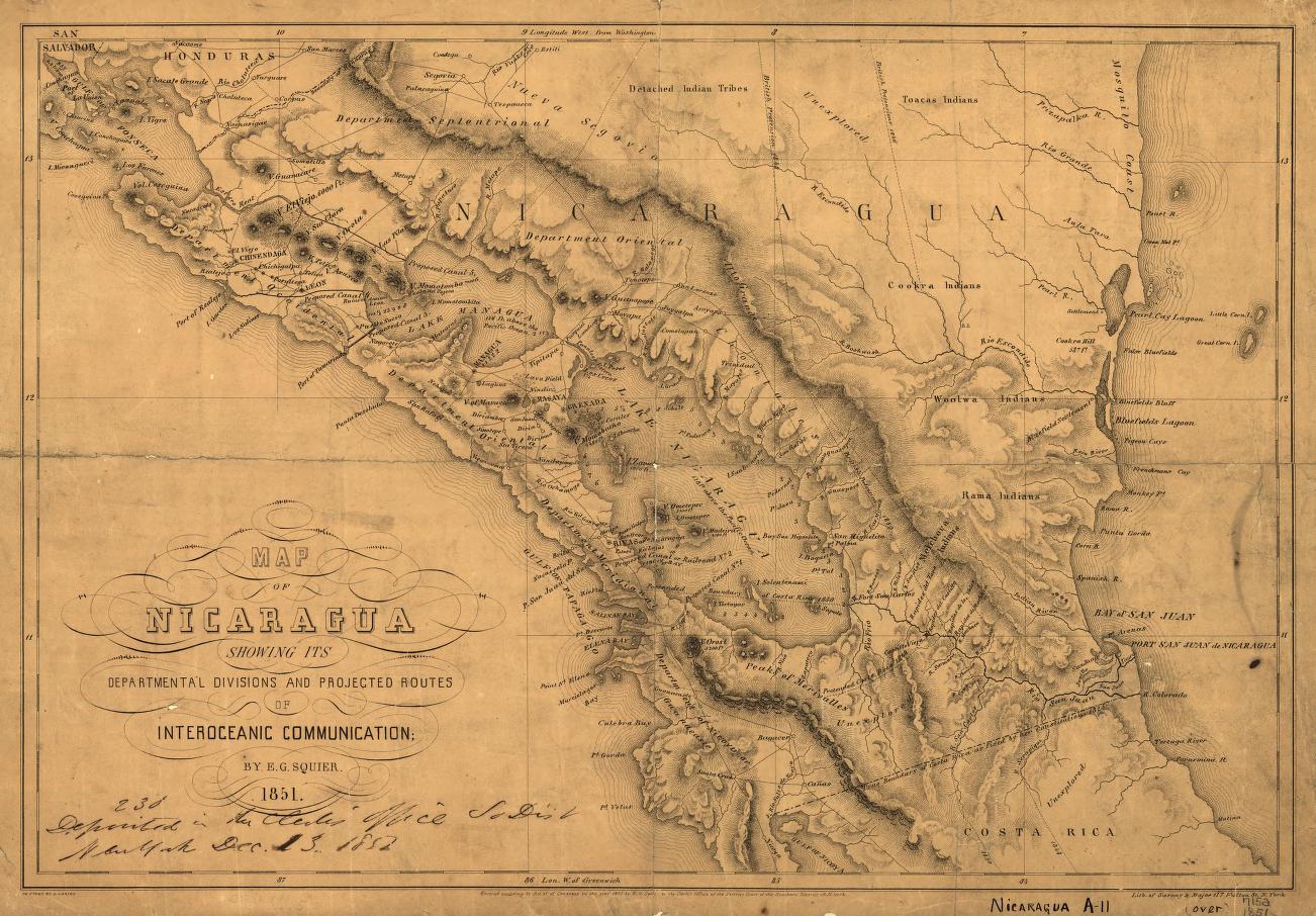
Dispossesions in the Americas

Dispossesions in the Americas

  • Inicio
  • Explorar
  • Autores
  • Sobre
  • Arte
  • Cuerpos
  • Planes de Estudio
  • Herencia Cultural
  • Mapas
  • Territorios
Volver a Explorar

Leyendo en Inglés

Mapa 1851

Map of Nicaragua showing departmental divisionsand projected routes of interoceanic communication.

  • SARONY & MAJOR

Publicado: 1851

  • Descargar Imágen
  • Descargar Imágen
Mapa 1851

Map of Nicaragua showing departmental divisionsand projected routes of interoceanic communication.

  • SARONY & MAJOR

Publicado: 1851

  • Descargar Imágen

Pueblos

  • TOACAS INDIANS
  • COOKRA INDIANS
  • WOOLWA INDIANS
  • RAMA INDIANS

Cita

Map of Nicaragua showing departmental divisionsand projected routes of interoceanic communication. Sarony & Major. 1851. New York. Library of Congress.G4850 1851 .S2 TIL. http://hdl.loc.gov/loc.gmd/g4850.ct000428AccessedJuly252023

  • Descargar Imágen

Leyendo en Portugués

Mapa 1851

Map of Nicaragua showing departmental divisionsand projected routes of interoceanic communication.

  • SARONY & MAJOR

Publicado: 1851

  • Descargar Imágen

Pueblos

  • TOACAS INDIANS
  • COOKRA INDIANS
  • WOOLWA INDIANS
  • RAMA INDIANS

Cita

Map of Nicaragua showing departmental divisionsand projected routes of interoceanic communication. Sarony & Major. 1851. New York. Library of Congress.G4850 1851 .S2 TIL. http://hdl.loc.gov/loc.gmd/g4850.ct000428AccessedJuly252023

  • Descargar Imágen

Artículos Relacionados

PUEBLO JÍBARO

PUEBLO JÍBARO

Mapa 2021
Kiñe Lafken Ngelay Afpun [Un Océano Sin Frontera]

Kiñe Lafken Ngelay Afpun [Un Océano Sin Frontera]

Obra de Arte
Geographical Distribution of the Huave

Geographical Distribution of the Huave

Mapa 1969
Provincia multiétnica y cultural

Provincia multiétnica y cultural

Mapa 2005
El mapa de los pueblos indígenas de Bolivia

El mapa de los pueblos indígenas de Bolivia

Mapa 2007
L'Amerique Meridionale Divisée en ses Principales Parties. Presenté à Monseigneur le Duc de Bourgogne

L'Amerique Meridionale Divisée en ses Principales Parties. Presenté à Monseigneur le Duc de Bourgogne

Mapa 1694
Territorio de las Misiones Jesuí!cas de Guaraníes: Pueblo y estancias. Mediados del siglo XVIII

Territorio de las Misiones Jesuí!cas de Guaraníes: Pueblo y estancias. Mediados del siglo XVIII

Mapa 1700 - 1799
VENEZUELA - KOLUMBIEN – EKUADOR

VENEZUELA - KOLUMBIEN – EKUADOR

Mapa 1924

Despojos en las Américas

Un Proyecto de

University of Pennsylvania

Copyright 2024

Con el apoyo de

Mellon Foundation

Diseño y Desarrollo del Sitio

Element 84

Créditos Artísticos

Map of Nicaragua showing departmental divisionsand projected routes of interoceanic communication. Sarony & Major. 1851. New York. Library of Congress.G4850 1851 .S2 TIL. http://hdl.loc.gov/loc.gmd/g4850.ct000428AccessedJuly252023

Páginas del Sitio

  • Inicio
  • Explorar
  • Autores
  • Sobre
  • Arte
  • Cuerpos
  • Planes de Estudio
  • Herencia Cultural
  • Mapas
  • Territorios