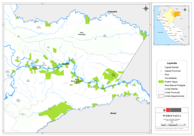
Dispossesions in the Americas

Dispossesions in the Americas

  • Inicio
  • Explorar
  • Autores
  • Sobre
  • Arte
  • Cuerpos
  • Planes de Estudio
  • Herencia Cultural
  • Mapas
  • Territorios
Volver a Explorar

Leyendo en Inglés

Mapa 1927

Preliminary Map;portion of north east [sic] Nicaragua: Brown's Camp to Pis Pis District.

    Publicado: 1927

    • Descargar Imágen
    • Descargar Imágen
    Mapa 1927

    Preliminary Map;portion of north east [sic] Nicaragua: Brown's Camp to Pis Pis District.

      Publicado: 1927

      • Descargar Imágen

      Pueblos

      • INDIAN
      • WAWA

      Citas

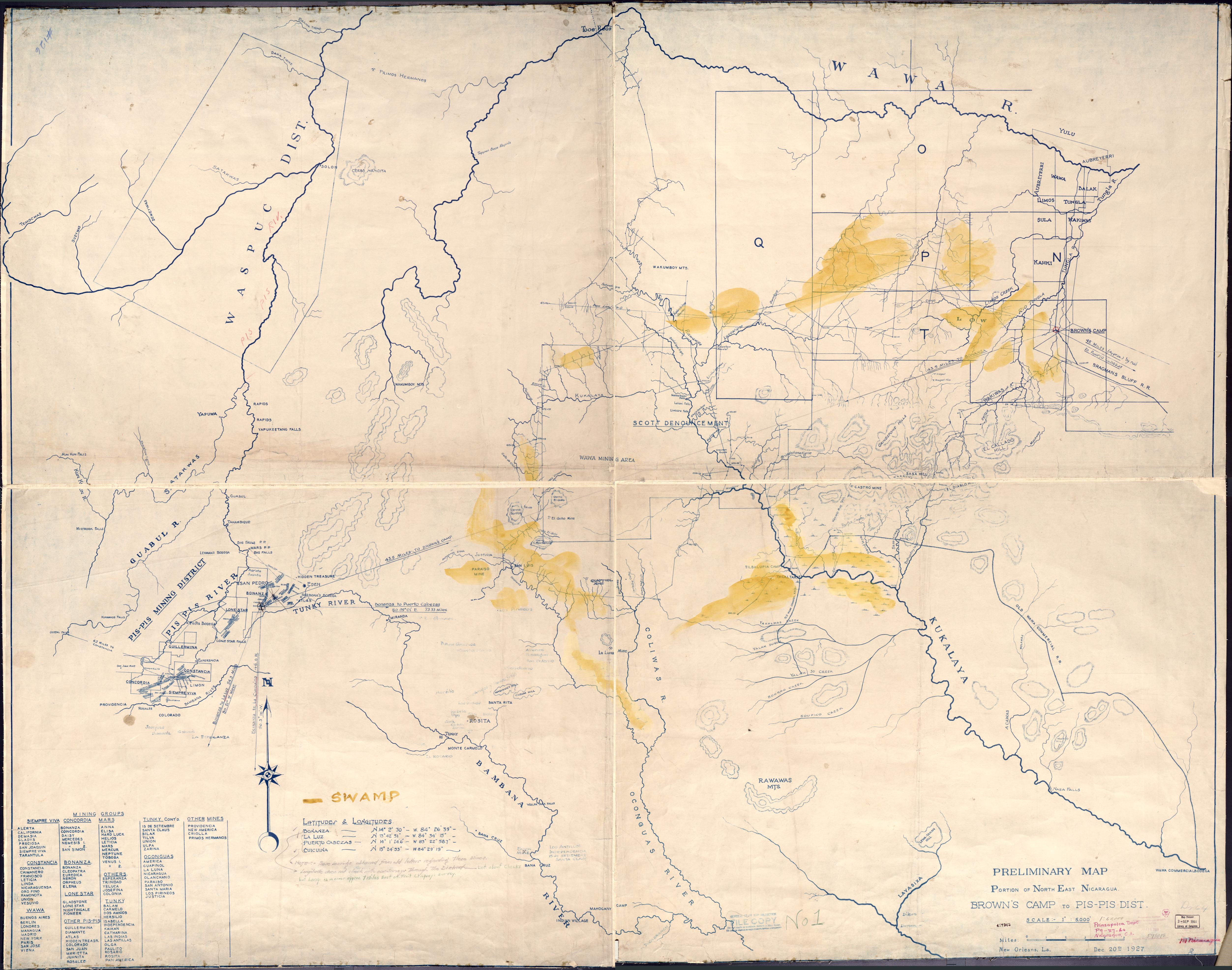
      Preliminary Map;portion of north east [sic] Nicaragua: Brown's Camp to Pis Pis District. New Orleans: [s.n] 1927.Library of Congress Geography and Maps Division. G4851.H1 1927 .P7. https://www.loc.gov/item/2006636639/AccessedJuly252023.

      • Descargar Imágen

      Artículos Relacionados

      REPRESENTACIÓN EN FORMA DE TRÍPTICO DE LAS TIERRAS DE TEPAL;CUENCA;CORRESPONDE AL EXPEDIENTE PROMOVIDO POR POSESIÓN DE TIERRAS ENTRE LOS INDÍGENAS DE SANTA ANA DE PICHACAY CONTRA MARÍA Y FRANCISCA CAZAR

      REPRESENTACIÓN EN FORMA DE TRÍPTICO DE LAS TIERRAS DE TEPAL;CUENCA;CORRESPONDE AL EXPEDIENTE PROMOVIDO POR POSESIÓN DE TIERRAS ENTRE LOS INDÍGENAS DE SANTA ANA DE PICHACAY CONTRA MARÍA Y FRANCISCA CAZAR

      Mapa 1828
      PUEBLO HUICHOL

      PUEBLO HUICHOL

      Mapa 2020
      Esquisse géologique de la Guyane française [Feuille Nord]

      Esquisse géologique de la Guyane française [Feuille Nord]

      Mapa 1949
      Nuremberg Map of Tenochititlan and the Gulf Coast, 1524

      Nuremberg Map of Tenochititlan and the Gulf Coast, 1524

      Mapa 1524
      Mapa IX.1 Familias y lenguas indígenas del Caribe Continental

      Mapa IX.1 Familias y lenguas indígenas del Caribe Continental

      Mapa 2009
      PUEBLO NAHUA DE MILPA ALTA

      PUEBLO NAHUA DE MILPA ALTA

      Mapa 2020
      Asiento del pueblo de Santiago Atitlán c 1585.

      Asiento del pueblo de Santiago Atitlán c 1585.

      Mapa 1585
      BORRADOR TOPOGRÁFICO DE LA LÍNEA DIVISORIA, QUE CITA EL ARTÍCULO 12º DEL TRATADO PRELIMINAR, Y AJUSTADAS DISTANCIAS HASTA SU PUNTO FINAL

      BORRADOR TOPOGRÁFICO DE LA LÍNEA DIVISORIA, QUE CITA EL ARTÍCULO 12º DEL TRATADO PRELIMINAR, Y AJUSTADAS DISTANCIAS HASTA SU PUNTO FINAL

      Mapa 1800 - 1850

      Despojos en las Américas

      Un Proyecto de

      University of Pennsylvania

      Copyright 2024

      Con el apoyo de

      Mellon Foundation

      Diseño y Desarrollo del Sitio

      Element 84

      Créditos Artísticos

      Preliminary Map;portion of north east [sic] Nicaragua: Brown’s Camp to Pis Pis District. New Orleans: [s.n] 1927.Library of Congress Geography and Maps Division. G4851.H1 1927 .P7. https://www.loc.gov/item/2006636639/AccessedJuly252023.

      Páginas del Sitio

      • Inicio
      • Explorar
      • Autores
      • Sobre
      • Arte
      • Cuerpos
      • Planes de Estudio
      • Herencia Cultural
      • Mapas
      • Territorios