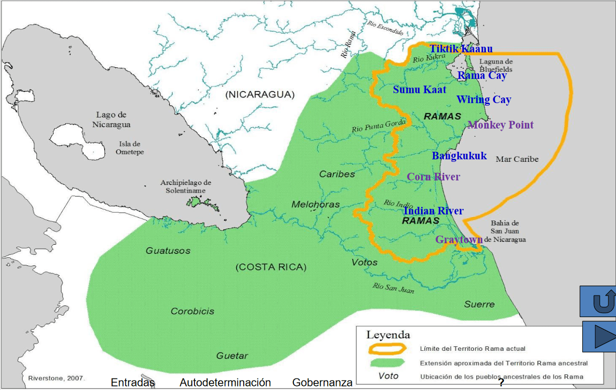
Dispossesions in the Americas

Dispossesions in the Americas

  • Inicio
  • Explorar
  • Autores
  • Sobre
  • Arte
  • Cuerpos
  • Planes de Estudio
  • Herencia Cultural
  • Mapas
  • Territorios
Volver a Explorar

Leyendo en Inglés

Mapa 1400 2022

Pueblos Originarios y Afrodescendientes de Nicaragua, Etnografía, ecosistemas naturales y áreas protegidas

    Publicado: 2022

    • Descargar Imágen
    • Descargar Imágen
    Mapa 1400 2022

    Pueblos Originarios y Afrodescendientes de Nicaragua, Etnografía, ecosistemas naturales y áreas protegidas

      Publicado: 2022

      • Descargar Imágen

      Pueblos

      • RAMA

      Citas

      "Pueblos Originarios y Afrodescendientes de Nicaragua, Etnografía, ecosistemas naturales y áreas protegidas." Accesed from Native Land: RAMA TERRITORY Nativeland.ca. https://native-land.ca/maps/territories/rama/ Accessed July 11 2023

      • Descargar Imágen

      Artículos Relacionados

      Departamentos y municipios de mayor concentración del pueblo Arhuaco

      Departamentos y municipios de mayor concentración del pueblo Arhuaco

      Mapa 2005
      America Meridionalis

      America Meridionalis

      Mapa 1619
      Guyana

      Guyana

      Mapa 1800 - 1899
      MAPA QUE COMPRENDE TODO EL DISTRITO DE LA AUDIENCIA DE QUITO

      MAPA QUE COMPRENDE TODO EL DISTRITO DE LA AUDIENCIA DE QUITO

      Mapa 1779
      Outlines of the physical and political division of South America: Delineated by A. Arrowsmith partly from scarce and original documents, published before the year 1806 but principally from manuscript maps & surveys made between the years 1771 and 1806, corrected from accurate astronomical observations to 1810.

      Outlines of the physical and political division of South America: Delineated by A. Arrowsmith partly from scarce and original documents, published before the year 1806 but principally from manuscript maps & surveys made between the years 1771 and 1806, corrected from accurate astronomical observations to 1810.

      Mapa 1800 - 1899
      Geographisch-statistische und historische Charte von Guyana.

      Geographisch-statistische und historische Charte von Guyana.

      Mapa 1800 - 1899
      FACSIMILE: PART OF SOUTH AMERICA BY DELISLE

      FACSIMILE: PART OF SOUTH AMERICA BY DELISLE

      Mapa 1700
      CARTE ITINÉRAIRE DU COURS DE L’ORÉNOQUE;DE L’ATABAPO;DU CASIQUIARE;ET DU RIO NEGRO OFFRANT la bifurcation de l’Orénoque et sa communication avec la Rivière des Amazones

      CARTE ITINÉRAIRE DU COURS DE L’ORÉNOQUE;DE L’ATABAPO;DU CASIQUIARE;ET DU RIO NEGRO OFFRANT la bifurcation de l’Orénoque et sa communication avec la Rivière des Amazones

      Mapa 1802

      Despojos en las Américas

      Un Proyecto de

      University of Pennsylvania

      Copyright 2024

      Con el apoyo de

      Mellon Foundation

      Diseño y Desarrollo del Sitio

      Element 84

      Créditos Artísticos

      “Pueblos Originarios y Afrodescendientes de Nicaragua, Etnografía, ecosistemas naturales y áreas protegidas.” Accesed from Native Land: RAMA TERRITORY Nativeland.ca. https://native-land.ca/maps/territories/rama/ Accessed July 11 2023

      Páginas del Sitio

      • Inicio
      • Explorar
      • Autores
      • Sobre
      • Arte
      • Cuerpos
      • Planes de Estudio
      • Herencia Cultural
      • Mapas
      • Territorios