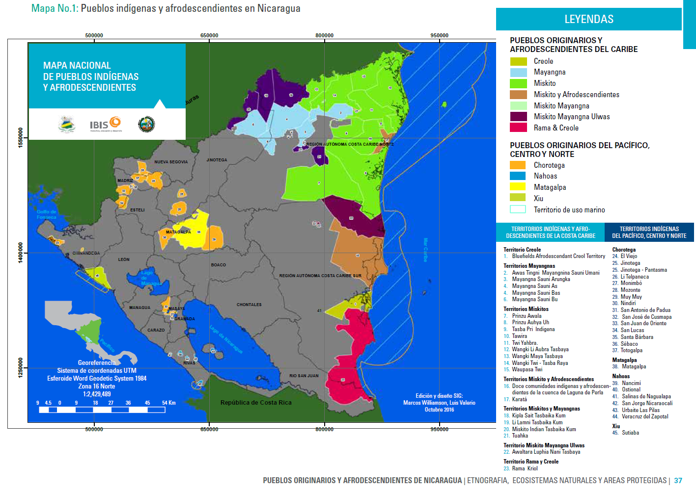
Dispossesions in the Americas

Dispossesions in the Americas

  • Inicio
  • Explorar
  • Autores
  • Sobre
  • Arte
  • Cuerpos
  • Planes de Estudio
  • Herencia Cultural
  • Mapas
  • Territorios
Volver a Explorar

Leyendo en Inglés

Mapa 2016

Mapa Nacional de Pueblos Indígenas y Afrodescendientes

  • MARCOS WILLIAMS;LUIS VALERIO

Publicado: 2016

  • Descargar Imágen
  • Descargar Imágen
Mapa 2016

Mapa Nacional de Pueblos Indígenas y Afrodescendientes

  • MARCOS WILLIAMS;LUIS VALERIO

Publicado: 2016

  • Descargar Imágen

Pueblos

  • CREOLE
  • MAYANGNA
  • MISKITO
  • MISKITO Y AFRODESCENDIENTES
  • MISKITO MAYANGNA
  • MISKITO MAYANGNA ULWAS
  • RAMA & CREOLE
  • CHOROTEGA
  • NAHOAS
  • MATAGALPA
  • XIU

Cita

MARCOS WILLIAMS;LUIS VALERIO. Mapa Nacional de Pueblos Indígenas y Afrodescendientes. Edición y diseño SIG. Octubre 2016. In; Ethnografia;Ecosistemas Naturales y Areas Protegidas. Nativeland.ca. Territories: Rama. Accessed July 11 2023 https://native-land.ca/maps/territories/rama/

  • Descargar Imágen

Leyendo en Portugués

Mapa 2016

Mapa Nacional de Pueblos Indígenas y Afrodescendientes

  • MARCOS WILLIAMS;LUIS VALERIO

Publicado: 2016

  • Descargar Imágen

Pueblos

  • CREOLE
  • MAYANGNA
  • MISKITO
  • MISKITO Y AFRODESCENDIENTES
  • MISKITO MAYANGNA
  • MISKITO MAYANGNA ULWAS
  • RAMA & CREOLE
  • CHOROTEGA
  • NAHOAS
  • MATAGALPA
  • XIU

Cita

MARCOS WILLIAMS;LUIS VALERIO. Mapa Nacional de Pueblos Indígenas y Afrodescendientes. Edición y diseño SIG. Octubre 2016. In; Ethnografia;Ecosistemas Naturales y Areas Protegidas. Nativeland.ca. Territories: Rama. Accessed July 11 2023 https://native-land.ca/maps/territories/rama/

  • Descargar Imágen

Artículos Relacionados

Geographical Distribution of the Cuicatec

Geographical Distribution of the Cuicatec

Mapa 1969
Población comcaac (seri) en 2010

Población comcaac (seri) en 2010

Mapa 2010
NATIVE RACES of the PACIFIC STATES

NATIVE RACES of the PACIFIC STATES

Mapa 1800
Carte du Gouvernement de Cayenne.

Carte du Gouvernement de Cayenne.

Mapa 1700 - 1799
PUEBLO ARABELA

PUEBLO ARABELA

Mapa 2021
Map representing the linguistic diversity that existed in Central America and the Gulf of Fonseca at the time of contact with the Spanish

Map representing the linguistic diversity that existed in Central America and the Gulf of Fonseca at the time of contact with the Spanish

Mapa 1522
PINTURA DE IZTAPALAPA

PINTURA DE IZTAPALAPA

Mapa 1500 - 1599
Guarani Retã 2008: Pueblos Guaraníes en las fronteras Argentina, Brasil y Paraguay

Guarani Retã 2008: Pueblos Guaraníes en las fronteras Argentina, Brasil y Paraguay

Mapa 2008

Despojos en las Américas

Un Proyecto de

University of Pennsylvania

Copyright 2024

Con el apoyo de

Mellon Foundation

Diseño y Desarrollo del Sitio

Element 84

Créditos Artísticos

MARCOS WILLIAMS;LUIS VALERIO. Mapa Nacional de Pueblos Indígenas y Afrodescendientes. Edición y diseño SIG. Octubre 2016. In; Ethnografia;Ecosistemas Naturales y Areas Protegidas. Nativeland.ca. Territories: Rama. Accessed July 11 2023 https://native-land.ca/maps/territories/rama/

Páginas del Sitio

  • Inicio
  • Explorar
  • Autores
  • Sobre
  • Arte
  • Cuerpos
  • Planes de Estudio
  • Herencia Cultural
  • Mapas
  • Territorios