Dispossesions in the Americas

Dispossesions in the Americas

  • Inicio
  • Explorar
  • Autores
  • Sobre
  • Arte
  • Cuerpos
  • Planes de Estudio
  • Herencia Cultural
  • Mapas
  • Territorios
Volver a Explorar

Leyendo en Inglés

Mapa 1757

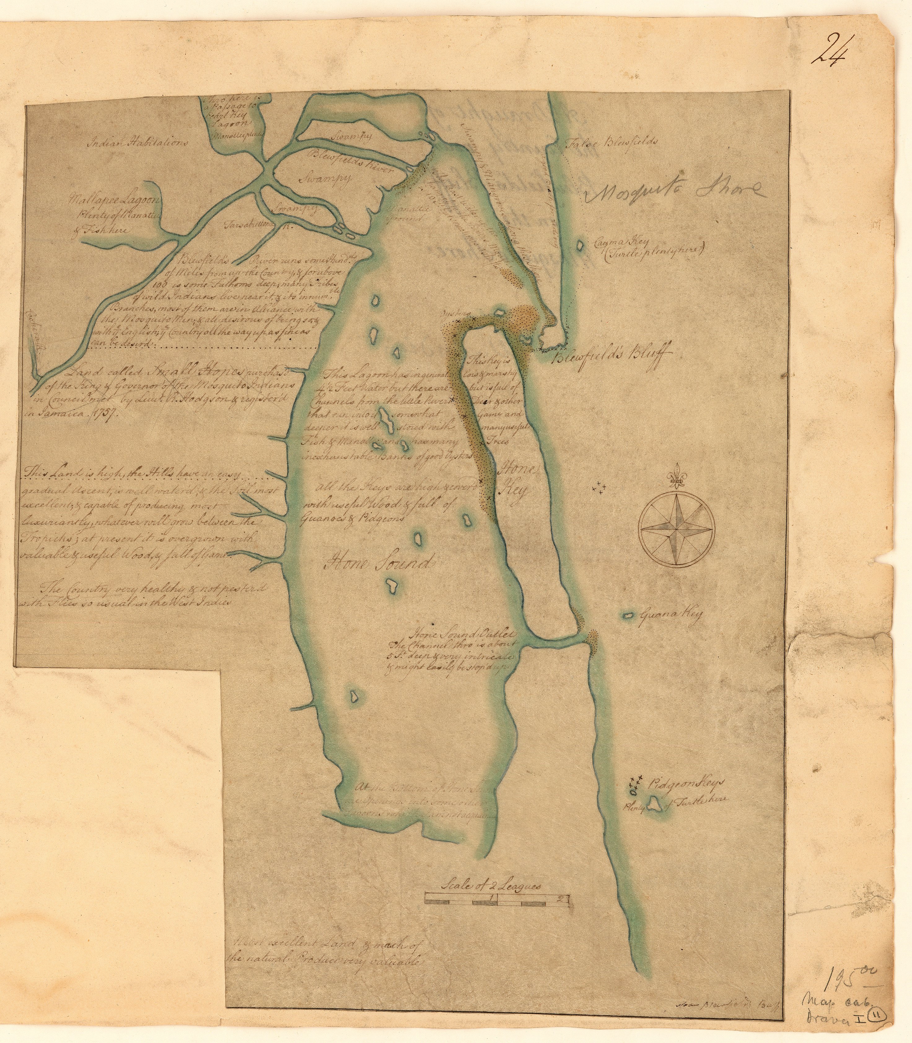
A draught of the country near Blewfields Bluff on the Mosquito Shore

    Publicado: 1757

    • Descargar Imágen
    • Descargar Imágen
    Mapa 1757

    A draught of the country near Blewfields Bluff on the Mosquito Shore

      Publicado: 1757

      • Descargar Imágen

      Pueblos

      • MOSQUITOS
      • INDIANS

      Citas

      A draught of the country near Blewfields Bluff on the Mosquito Shore. 1757. John Carter Brown Map Collection. C-6713. File Name: C-6713-000. https://jcb.lunaimaging.com/luna/servlet/detail/JCBMAPS~1~1~6420~115902733:A-draught-of-the-country-near-Blewf?qvq=q:Nicaragua;lc:JCBMAPS~2~2;JCBMAPS~3~3;JCB~1~1;JCB~3~3;JCBBOOKS~1~1;JCBMAPS~1~1&mi=11&trs=66#
      • Descargar Imágen

      Artículos Relacionados

      La Guyane française : Ses limited de 1814, d'après la carte de Leblond.

      La Guyane française : Ses limited de 1814, d'après la carte de Leblond.

      Mapa 1814
      CARTA ETNICA DEL GRAN CHACO EN EL UMBRAL DEL S.XX

      CARTA ETNICA DEL GRAN CHACO EN EL UMBRAL DEL S.XX

      Mapa 1875 - 1935
      Pueblos Originarios y Afrodescendientes de Nicaragua, Etnografía, ecosistemas naturales y áreas protegidas

      Pueblos Originarios y Afrodescendientes de Nicaragua, Etnografía, ecosistemas naturales y áreas protegidas

      Mapa 1400 2022
      ITINÉRAIRES DE LA MISSION DE BRETTES Dans le Grand Chaco Septentrional (Voyage 1886, 1887-1888)

      ITINÉRAIRES DE LA MISSION DE BRETTES Dans le Grand Chaco Septentrional (Voyage 1886, 1887-1888)

      Mapa 1886 - 1888
      Lengua Pilagá - Ubicación geográfica

      Lengua Pilagá - Ubicación geográfica

      Mapa 2021
      Guyanes. Amér. Mérid. no. 7. (Dresse par Ph. Vandermaelen, lithographie par H. Ode. Cinquième partie. - Amer. merid. Bruxelles. 1827)

      Guyanes. Amér. Mérid. no. 7. (Dresse par Ph. Vandermaelen, lithographie par H. Ode. Cinquième partie. - Amer. merid. Bruxelles. 1827)

      Mapa 1800 - 1899
      CARTE DE LA DEPENDANCE DU YAPOK JUSQU'A la Riviere des Amazones

      CARTE DE LA DEPENDANCE DU YAPOK JUSQU'A la Riviere des Amazones

      Mapa 1737
      Le Cours de la Riviere des Amazones

      Le Cours de la Riviere des Amazones

      Mapa 1680

      Despojos en las Américas

      Un Proyecto de

      University of Pennsylvania

      Copyright 2024

      Con el apoyo de

      Mellon Foundation

      Diseño y Desarrollo del Sitio

      Element 84

      Créditos Artísticos

      A draught of the country near Blewfields Bluff on the Mosquito Shore. 1757. John Carter Brown Map Collection. C-6713. File Name: C-6713-000. https://jcb.lunaimaging.com/luna/servlet/detail/JCBMAPS~1~1~6420~115902733:A-draught-of-the-country-near-Blewf?qvq=q:Nicaragua;lc:JCBMAPS~2~2;JCBMAPS~3~3;JCB~1~1;JCB~3~3;JCBBOOKS~1~1;JCBMAPS~1~1&mi=11&trs=66#
      Páginas del Sitio

      • Inicio
      • Explorar
      • Autores
      • Sobre
      • Arte
      • Cuerpos
      • Planes de Estudio
      • Herencia Cultural
      • Mapas
      • Territorios