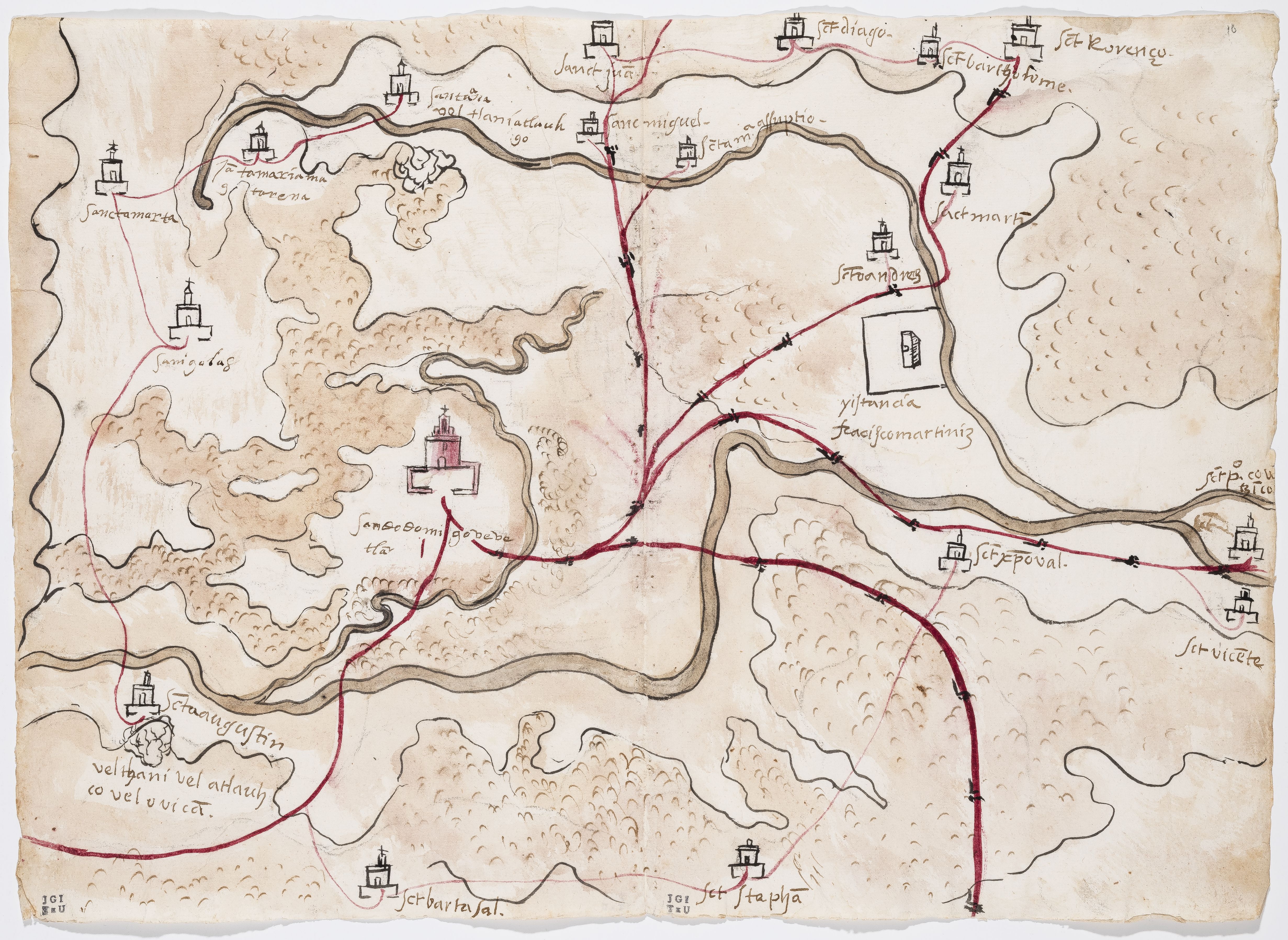
Dispossesions in the Americas

Dispossesions in the Americas

  • Inicio
  • Explorar
  • Autores
  • Sobre
  • Arte
  • Cuerpos
  • Planes de Estudio
  • Herencia Cultural
  • Mapas
  • Territorios
Volver a Explorar

Leyendo en Inglés

Mapa 1500 - 1599

PINTURA DE GUEGUETLAN

    Publicado: 1579

    • Descargar Imágen
    • Descargar Imágen
    Mapa 1500 - 1599

    PINTURA DE GUEGUETLAN

      Publicado: 1579

      • Descargar Imágen

      Citas

      Unknown. Pintura de Gueguetlan. Map. Benson Latin American Collection, LLILAS Benson Latin American Studies and Collections, The University of Texas at Austin, 1579. Relaciones Geográficas of Mexico and Guatemala https://txarchives.org/utlac/finding_aids/00056.xml

      • Descargar Imágen

      Artículos Relacionados

      Distribución geográfica de las ramas mayores de los idiomas mayas en su origen histórico.

      Distribución geográfica de las ramas mayores de los idiomas mayas en su origen histórico.

      Mapa
      Map of Culhuacan (Valley of Mexico), 1580, Relacion geografica de Culhuacan

      Map of Culhuacan (Valley of Mexico), 1580, Relacion geografica de Culhuacan

      Mapa 1580
      Izquyluca; Tenayuca. Distrito Federal, 1594

      Izquyluca; Tenayuca. Distrito Federal, 1594

      Mapa 1594
      EL TERRITORIO AYOREO EN EL MAPA DE PARAGUAY HOY

      EL TERRITORIO AYOREO EN EL MAPA DE PARAGUAY HOY

      Mapa 2010
      Paraguay Verdeelt in zyn voornaamste deelen Volgens de
     laatste reisbeschryvinge door N. Sanson d.'Abbeville, Geographe ordre. du
     Ro

      Paraguay Verdeelt in zyn voornaamste deelen Volgens de laatste reisbeschryvinge door N. Sanson d.'Abbeville, Geographe ordre. du Ro

      Mapa 1600 - 1667
      Geographic Distribution of Huichol and Cora, Showing Towns and Elevations

      Geographic Distribution of Huichol and Cora, Showing Towns and Elevations

      Mapa 1969
      [Carte de la Guyane depuis le Marony jusqu'au Yary]

      [Carte de la Guyane depuis le Marony jusqu'au Yary]

      Mapa 1766
      Land-kaart van het eiland en de volksplanting van Cayenne aan de kust van Zuid-Amerika

      Land-kaart van het eiland en de volksplanting van Cayenne aan de kust van Zuid-Amerika

      Mapa 1769

      Despojos en las Américas

      Un Proyecto de

      University of Pennsylvania

      Copyright 2024

      Con el apoyo de

      Mellon Foundation

      Diseño y Desarrollo del Sitio

      Element 84

      Créditos Artísticos

      Unknown. Pintura de Gueguetlan. Map. Benson Latin American Collection, LLILAS Benson Latin American Studies and Collections, The University of Texas at Austin, 1579. Relaciones Geográficas of Mexico and Guatemala https://txarchives.org/utlac/finding_aids/00056.xml

      Páginas del Sitio

      • Inicio
      • Explorar
      • Autores
      • Sobre
      • Arte
      • Cuerpos
      • Planes de Estudio
      • Herencia Cultural
      • Mapas
      • Territorios