Dispossesions in the Americas

Dispossesions in the Americas

  • Inicio
  • Explorar
  • Autores
  • Sobre
  • Arte
  • Cuerpos
  • Planes de Estudio
  • Herencia Cultural
  • Mapas
  • Territorios
Volver a Explorar

Leyendo en Inglés

Mapa 1500 - 1599

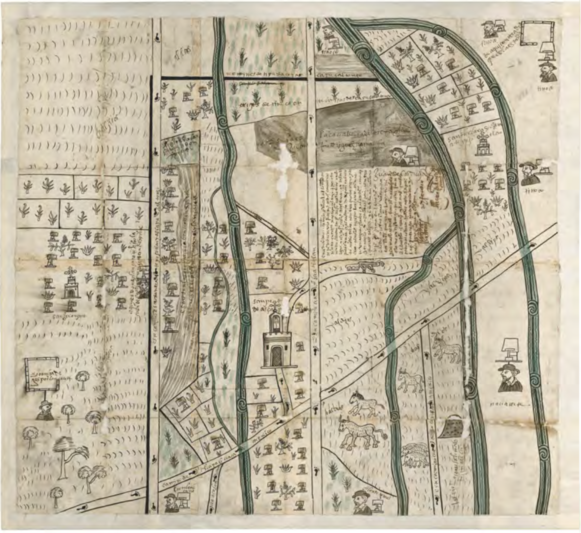
MAPA DE SAN PEDRO AZCAPOTZALTONGO

    Publicado: 1578

    • Descargar Imágen
    • Descargar Imágen
    Mapa 1500 - 1599

    MAPA DE SAN PEDRO AZCAPOTZALTONGO

      Publicado: 1578

      • Descargar Imágen

      Citas

      García Redondo, José María. ""Estudio introductorio. Cartografía tradicional de los pueblos de México. Mapas indígenas y mestizos."" In El primer mapa de México, 11-41. N.p.: Fomento Cultural Grupo Salinas, 2021." https://digital.csic.es/bitstream/10261/271989/1/Estudio_introductorio.pdf
      • Descargar Imágen

      Artículos Relacionados

      Figure 10.1. Map of Ecuador showing the Western Pichincha research region and the site of Palmitopamba.

      Figure 10.1. Map of Ecuador showing the Western Pichincha research region and the site of Palmitopamba.

      Mapa -700 - 1534
      Mapa del Corregimiento de Tecpanatitlan

      Mapa del Corregimiento de Tecpanatitlan

      Mapa 1690
      Accuratissima Brasiliae Tabula

      Accuratissima Brasiliae Tabula

      Mapa 1600 - 1699
      Mazatec Area

      Mazatec Area

      Mapa 1969
      CARTA GEOGRÁFICA DEL ECUADOR POR DR. TEODORO WOLF;PUBLICADA POR ORDEN DEL SUPREMO GOBIERNO DE LA REPÚBLICA Y TRABAJADA BAJO LAS PRESIDENCIAS DE LOS EE. SEÑORES DR. D.J.M. PLÁCIDO CAAMAÑO Y DR. D. ANTONIO FLORES. 1892 ... INSTITUTO GEOGRAFICO DE H. WAGNER & E. DEBES EN LEIPZIG. (WITH) LA REGION ORIENTAL DEL ECUADOR. (WITH) ARCHIPIÉLAGO DE GALÁPAGOS.

      CARTA GEOGRÁFICA DEL ECUADOR POR DR. TEODORO WOLF;PUBLICADA POR ORDEN DEL SUPREMO GOBIERNO DE LA REPÚBLICA Y TRABAJADA BAJO LAS PRESIDENCIAS DE LOS EE. SEÑORES DR. D.J.M. PLÁCIDO CAAMAÑO Y DR. D. ANTONIO FLORES. 1892 ... INSTITUTO GEOGRAFICO DE H. WAGNER & E. DEBES EN LEIPZIG. (WITH) LA REGION ORIENTAL DEL ECUADOR. (WITH) ARCHIPIÉLAGO DE GALÁPAGOS.

      Mapa 1892
      Territorios significativos

      Territorios significativos

      Mapa 2010 - 2020
      Guatemala, from official and other sources.

      Guatemala, from official and other sources.

      Mapa 1900
      San Marcos

      San Marcos

      Mapa 1997

      Despojos en las Américas

      Un Proyecto de

      University of Pennsylvania

      Copyright 2024

      Con el apoyo de

      Mellon Foundation

      Diseño y Desarrollo del Sitio

      Element 84

      Créditos Artísticos

      García Redondo, José María. ““Estudio introductorio. Cartografía tradicional de los pueblos de México. Mapas indígenas y mestizos.”” In El primer mapa de México, 11-41. N.p.: Fomento Cultural Grupo Salinas, 2021." https://digital.csic.es/bitstream/10261/271989/1/Estudio_introductorio.pdf
      Páginas del Sitio

      • Inicio
      • Explorar
      • Autores
      • Sobre
      • Arte
      • Cuerpos
      • Planes de Estudio
      • Herencia Cultural
      • Mapas
      • Territorios