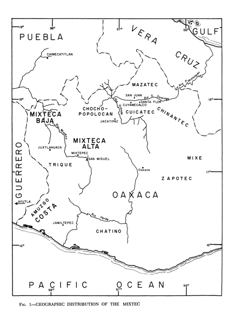
Dispossesions in the Americas

Dispossesions in the Americas

  • Inicio
  • Explorar
  • Autores
  • Sobre
  • Arte
  • Cuerpos
  • Planes de Estudio
  • Herencia Cultural
  • Mapas
  • Territorios
Volver a Explorar

Leyendo en Inglés

Mapa 1969

Geographic Distribution of the Mixtec

  • ROBERT RAVICZ, A KIMBALL ROMNEY

Publicado: 1969

  • Descargar Imágen
  • Descargar Imágen
Mapa 1969

Geographic Distribution of the Mixtec

  • ROBERT RAVICZ, A KIMBALL ROMNEY

Publicado: 1969

  • Descargar Imágen

Pueblos

  • CHATINO
  • ZAPOTEC
  • MIXE
  • AMUZGO
  • TRIQUE
  • MIXTECA
  • CHOCHO-POPOLOCAN
  • MAZATEC
  • CUICATEC
  • CHINANTEC

Citas

Ravicz, Robert, and A. Kimball Romney. "The Mixtec." In Ethnology, edited by Robert Wauchope and Evon Z. Vogt, 367. Vols. 7-8 of Handbook of Middle American Indians. Austin: University of Texas Press, 1969. https://ebookcentral-proquest-com.proxy.library.upenn.edu/lib/upenn-ebooks/reader.action?docID=4826335&ppg=383.

  • Descargar Imágen

Artículos Relacionados

Carte du Gouvernement de Cayenne dans l'Amérique Méridionale

Carte du Gouvernement de Cayenne dans l'Amérique Méridionale

Mapa 1763
‘INDIAN ROYAL TOWNS’ (REDUCCIONES) AND PROVINCES (CORREGIMIENTOS) UNDER SPANISH COLONIAL RULE IN THE LATE 16TH CENTURY

‘INDIAN ROYAL TOWNS’ (REDUCCIONES) AND PROVINCES (CORREGIMIENTOS) UNDER SPANISH COLONIAL RULE IN THE LATE 16TH CENTURY

Mapa 1570 - 1650
TABASCO

TABASCO

Mapa 2015
Totocanapan: Approximate Extension in Ancient and Recent Times

Totocanapan: Approximate Extension in Ancient and Recent Times

Mapa 1940
TERRITORIOS DE LOS PUEBLOS Y NACIONALIDADES;TERRITORIOS DE VIDA Y AREAS PROTEGIDAS EN EL ECUADOR CONTINENTAL

TERRITORIOS DE LOS PUEBLOS Y NACIONALIDADES;TERRITORIOS DE VIDA Y AREAS PROTEGIDAS EN EL ECUADOR CONTINENTAL

Mapa 2016 - 2018
Mapa de la población total y porcentaje de indios;1776

Mapa de la población total y porcentaje de indios;1776

Mapa 1776
Carte des Isles Antilles ou du Vent Avec la partie orientale des Isles sous le vent

Carte des Isles Antilles ou du Vent Avec la partie orientale des Isles sous le vent

Mapa 1780
Outlines of the physical and political division of South America: Delineated by A. Arrowsmith partly from scarce and original documents, published before the year 1806 but principally from manuscript maps & surveys made between the years 1771 and 1806, corrected from accurate astronomical observations to 1810.

Outlines of the physical and political division of South America: Delineated by A. Arrowsmith partly from scarce and original documents, published before the year 1806 but principally from manuscript maps & surveys made between the years 1771 and 1806, corrected from accurate astronomical observations to 1810.

Mapa 1800 - 1899

Despojos en las Américas

Un Proyecto de

University of Pennsylvania

Copyright 2024

Con el apoyo de

Mellon Foundation

Diseño y Desarrollo del Sitio

Element 84

Créditos Artísticos

Ravicz, Robert, and A. Kimball Romney. “The Mixtec.” In Ethnology, edited by Robert Wauchope and Evon Z. Vogt, 367. Vols. 7-8 of Handbook of Middle American Indians. Austin: University of Texas Press, 1969. https://ebookcentral-proquest-com.proxy.library.upenn.edu/lib/upenn-ebooks/reader.action?docID=4826335&ppg=383.

Páginas del Sitio

  • Inicio
  • Explorar
  • Autores
  • Sobre
  • Arte
  • Cuerpos
  • Planes de Estudio
  • Herencia Cultural
  • Mapas
  • Territorios