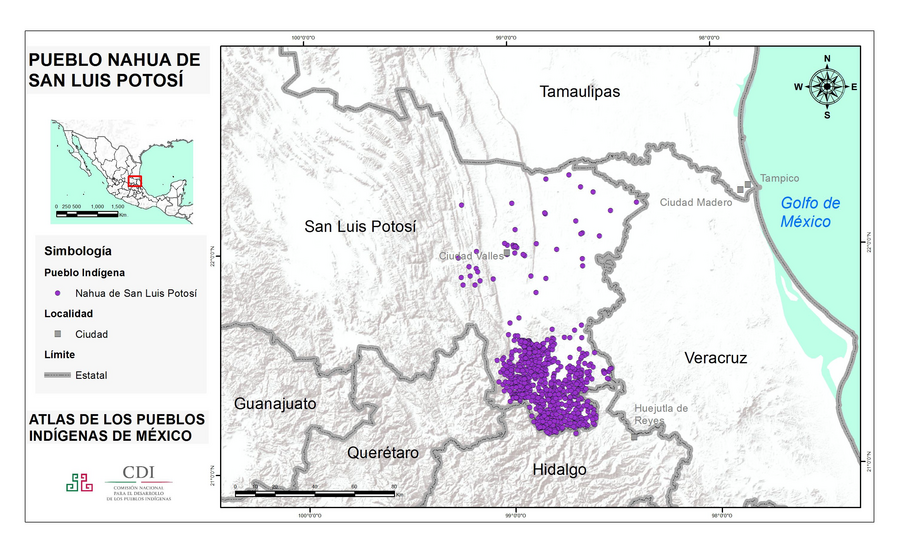
Dispossesions in the Americas

Dispossesions in the Americas

  • Inicio
  • Explorar
  • Autores
  • Sobre
  • Arte
  • Cuerpos
  • Planes de Estudio
  • Herencia Cultural
  • Mapas
  • Territorios
Volver a Explorar

Leyendo en Inglés

Mapa 2020

PUEBLO NAHUA DE SAN LUIS POTOSI

  • INSTITUTO NACIONAL DE LOS PUEBLOS INDIGENAS

Publicado: 2020

  • Descargar Imágen
  • Descargar Imágen
Mapa 2020

PUEBLO NAHUA DE SAN LUIS POTOSI

  • INSTITUTO NACIONAL DE LOS PUEBLOS INDIGENAS

Publicado: 2020

  • Descargar Imágen

Pueblos

  • NAHUA DE SAN LUIS POTOSI

Cita

Instituto Nacional de los Pueblos Indígenas. "Nahuas de San Luis Potosí – Ubicación." Atlas de los Pueblos Indígenas de México. Accessed August 14, 2021. http://atlas.inpi.gob.mx/nahuas-de-san-luis-potosi-ubicacion/.

  • Descargar Imágen

Leyendo en Portugués

Mapa 2020

PUEBLO NAHUA DE SAN LUIS POTOSI

  • INSTITUTO NACIONAL DE LOS PUEBLOS INDIGENAS

Publicado: 2020

  • Descargar Imágen

Pueblos

  • NAHUA DE SAN LUIS POTOSI

Cita

Instituto Nacional de los Pueblos Indígenas. "Nahuas de San Luis Potosí – Ubicación." Atlas de los Pueblos Indígenas de México. Accessed August 14, 2021. http://atlas.inpi.gob.mx/nahuas-de-san-luis-potosi-ubicacion/.

  • Descargar Imágen

Artículos Relacionados

Caracoles zapatistas

Caracoles zapatistas

Mapa 2016
PUEBLO IKITU

PUEBLO IKITU

Mapa 2021
Maya Centre

Maya Centre

Mapa 1997
SÜDAMERIKA, NÖRDLICHE HÄLFTE

SÜDAMERIKA, NÖRDLICHE HÄLFTE

Mapa 1902
No Title

No Title

Mapa 1619
Chili, Getrokken uit Alfonso de Ovalle, Jesuit, en in
     dertien Rechts-gebieden verdeelt Door N. Sanson d.'Abb. Geogr. ordre. du
     Roy

Chili, Getrokken uit Alfonso de Ovalle, Jesuit, en in dertien Rechts-gebieden verdeelt Door N. Sanson d.'Abb. Geogr. ordre. du Roy

Mapa 1600 - 1667
The Southern Maya Lowlands during the Sixteenth and Seventeenth Centuries

The Southern Maya Lowlands during the Sixteenth and Seventeenth Centuries

Mapa 1500 - 1700
Nieuwe Caerte van het wonderbaer ende goudrijcke landt Guiana, gelegen onder de Linie Aequinoctiael tusschen Brasilien ende Péru.

Nieuwe Caerte van het wonderbaer ende goudrijcke landt Guiana, gelegen onder de Linie Aequinoctiael tusschen Brasilien ende Péru.

Mapa 1500 - 1599

Despojos en las Américas

Un Proyecto de

University of Pennsylvania

Copyright 2024

Con el apoyo de

Mellon Foundation

Diseño y Desarrollo del Sitio

Element 84

Créditos Artísticos

Instituto Nacional de los Pueblos Indígenas. “Nahuas de San Luis Potosí – Ubicación.” Atlas de los Pueblos Indígenas de México. Accessed August 14, 2021. http://atlas.inpi.gob.mx/nahuas-de-san-luis-potosi-ubicacion/.

Páginas del Sitio

  • Inicio
  • Explorar
  • Autores
  • Sobre
  • Arte
  • Cuerpos
  • Planes de Estudio
  • Herencia Cultural
  • Mapas
  • Territorios