Pueblos
- KIKAPU
Cita
Instituto Nacional de los Pueblos Indígenas. "Kikapúes – Ubicación." Atlas de los Pueblos Indígenas de México. Accessed July 7, 2021. http://atlas.inpi.gob.mx/kikapues-ubicacion/.
MAP 7.—The Highland tribes of Colombia and Ecuador. (Drawn from data compiled by Gregorio Hernández de Alba;John Murra;Sergio Elías Ortíz;and Henri Lehmann.)
Mapa 1400
SAN LUIS POTOSÍ
Mapa 2015
Mapa de la Republica de Nicaragua y parte de las de Honduras y Costa Rica Continiendo los mejores datos conocidos hasta 1873
Mapa 1800 - 1873
Empire du BRÉSIL
Mapa 1835
"Territorio Indígena Brunka de Rey Curré"
Mapa 2010
CHART containing the greater part of the SOUTH SEA to the South of the LINE, with the ISLANDS dispersed thro' the same
Mapa 1794
DISTRIBUCION DE GRUPOS CHIBCHAS MENCIONADOS EN EL TEXTO
Mapa 2019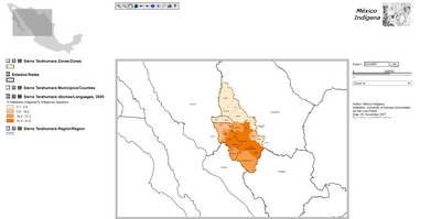
Sierra Tarahumara Study Area - Online GIS
Mapa 2005