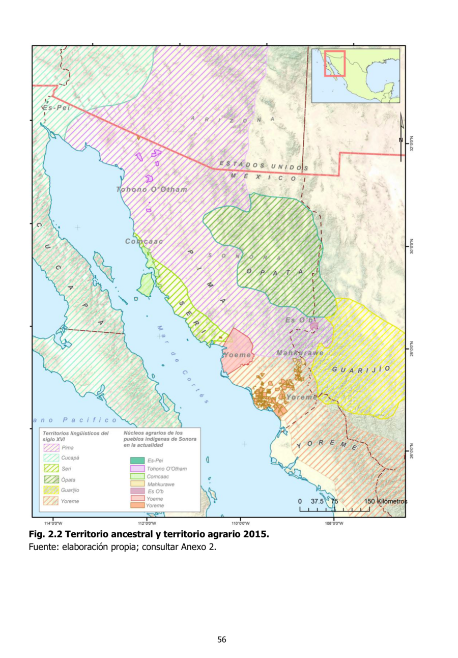
Dispossesions in the Americas

Dispossesions in the Americas

  • Inicio
  • Explorar
  • Autores
  • Sobre
  • Arte
  • Cuerpos
  • Planes de Estudio
  • Herencia Cultural
  • Mapas
  • Territorios
Volver a Explorar

Leyendo en Inglés

Mapa 2015

Territorio ancestral y territorio agrario 2015

  • DIANA LUQUE, ANGELINA MARTINEZ-YRIZAR, ALBERTO BURQUEZ, GERARDO LOPEZ CRUZ, ARTHUR D MURPHY

Publicado: 2016

  • Descargar Imágen
  • Descargar Imágen
Mapa 2015

Territorio ancestral y territorio agrario 2015

  • DIANA LUQUE, ANGELINA MARTINEZ-YRIZAR, ALBERTO BURQUEZ, GERARDO LOPEZ CRUZ, ARTHUR D MURPHY

Publicado: 2016

  • Descargar Imágen

Pueblos

  • CUCUPA
  • ES-PEI
  • TOHONO OOTHAM
  • COMCAAC
  • SERI
  • PIMA
  • OPATA
  • GUARIJIO
  • YOREME
  • YOEME
  • ES OB
  • MAHKURAWE

Citas

Luque, Diana, Angelina Martínez-Yrízar, Alberto Búrquez, Gerardo López Cruz, and Arthur D. Murphy. Complejos Bioculturales De Sonora Pueblos y Territorios Indigenas. Hermosillo, Sonora: Centro de Investigación en Alimentación y Desarrollo, A. C., 2016. https://www.researchgate.net/publication/311921880_Complejos_Bioculturales_De_Sonora_Pueblos_y_Territorios_Indigenas.

  • Descargar Imágen

Artículos Relacionados

Location of the main settlements on the Lenca-Chortí-Nahua-Pipil frontier, 1530-1539. (Taken from Lara-Pinto 2009 with modifications.)

Location of the main settlements on the Lenca-Chortí-Nahua-Pipil frontier, 1530-1539. (Taken from Lara-Pinto 2009 with modifications.)

Mapa 1530 - 1539
MAP OF SANTA CRUZ XOXOCOTLÁN

MAP OF SANTA CRUZ XOXOCOTLÁN

Mapa 1686
Mystequilla y Tegoantepec. Oaxaca, 1573

Mystequilla y Tegoantepec. Oaxaca, 1573

Mapa 1573
PINTURA DE TEOZACOALCO

PINTURA DE TEOZACOALCO

Mapa 1500 - 1599
FAMILIAS LINGUÍSTICAS Y LENGUAS INDÍGENAS. OCTAVA REGION: PENINSULA DE LA GUAJIRA

FAMILIAS LINGUÍSTICAS Y LENGUAS INDÍGENAS. OCTAVA REGION: PENINSULA DE LA GUAJIRA

Mapa 1989
Mapa de la parte de la Provincia de Comayagua ú Honduras en que habitan los indios Xicaques.

Mapa de la parte de la Provincia de Comayagua ú Honduras en que habitan los indios Xicaques.

Mapa 1798
PUEBLO SHARANAHUA

PUEBLO SHARANAHUA

Mapa 2021
THE AYMARA POLITY OF THE LUPAQA: EASTERN INTER-ANDEAN VALLEY COLONIES UNDER INCA RULE 16TH CENTURY

THE AYMARA POLITY OF THE LUPAQA: EASTERN INTER-ANDEAN VALLEY COLONIES UNDER INCA RULE 16TH CENTURY

Mapa 1560 - 1567

Despojos en las Américas

Un Proyecto de

University of Pennsylvania

Copyright 2024

Con el apoyo de

Mellon Foundation

Diseño y Desarrollo del Sitio

Element 84

Créditos Artísticos

Luque, Diana, Angelina Martínez-Yrízar, Alberto Búrquez, Gerardo López Cruz, and Arthur D. Murphy. Complejos Bioculturales De Sonora Pueblos y Territorios Indigenas. Hermosillo, Sonora: Centro de Investigación en Alimentación y Desarrollo, A. C., 2016. https://www.researchgate.net/publication/311921880_Complejos_Bioculturales_De_Sonora_Pueblos_y_Territorios_Indigenas.

Páginas del Sitio

  • Inicio
  • Explorar
  • Autores
  • Sobre
  • Arte
  • Cuerpos
  • Planes de Estudio
  • Herencia Cultural
  • Mapas
  • Territorios