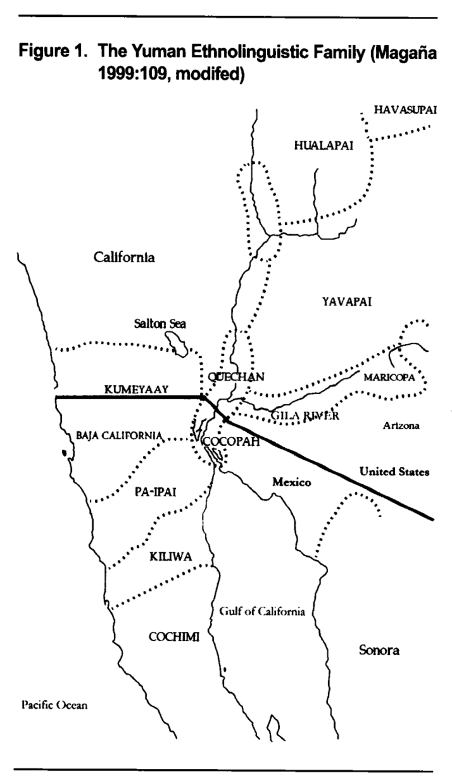
Dispossesions in the Americas

Dispossesions in the Americas

  • Inicio
  • Explorar
  • Autores
  • Sobre
  • Arte
  • Cuerpos
  • Planes de Estudio
  • Herencia Cultural
  • Mapas
  • Territorios
Volver a Explorar

Leyendo en Inglés

Mapa 2016

The Yuman Ethnolinguistic Family

  • EVERARDO GARDUNO

Publicado: 2016

  • Descargar Imágen
  • Descargar Imágen
Mapa 2016

The Yuman Ethnolinguistic Family

  • EVERARDO GARDUNO

Publicado: 2016

  • Descargar Imágen

Pueblos

  • KUMEYAAY
  • PA-IPAI
  • KILIWA
  • COCHIMI
  • COCOPAH
  • QUECHAN
  • MARICOPA
  • YAVAPAI
  • HUALAPAI
  • HAVASUPAI

Cita

Garduño, Everardo. "Making the Invisible Visible: The Yumans of the United States-Mexico Transborder Region." Human Organization 75, no. 2 Summer 2016: 118-28. https://www-proquest-com.proxy.library.upenn.edu/docview/1797683146/fulltext/E35F0B26F05345BBPQ/1?accountid=14707.

  • Descargar Imágen

Leyendo en Portugués

Mapa 2016

The Yuman Ethnolinguistic Family

  • EVERARDO GARDUNO

Publicado: 2016

  • Descargar Imágen

Pueblos

  • KUMEYAAY
  • PA-IPAI
  • KILIWA
  • COCHIMI
  • COCOPAH
  • QUECHAN
  • MARICOPA
  • YAVAPAI
  • HUALAPAI
  • HAVASUPAI

Cita

Garduño, Everardo. "Making the Invisible Visible: The Yumans of the United States-Mexico Transborder Region." Human Organization 75, no. 2 Summer 2016: 118-28. https://www-proquest-com.proxy.library.upenn.edu/docview/1797683146/fulltext/E35F0B26F05345BBPQ/1?accountid=14707.

  • Descargar Imágen

Artículos Relacionados

TERRITORIO DEL PUEBLO SHUAR ATRUAM

TERRITORIO DEL PUEBLO SHUAR ATRUAM

Mapa 2017
Carte particulière de la Coste de Cayenne depuis le Cap Nord jusques au Païs des Saimakotes

Carte particulière de la Coste de Cayenne depuis le Cap Nord jusques au Païs des Saimakotes

Mapa 1600 - 1699
Carte particulière des costes de la Capitainerie de Siara au Brésil

Carte particulière des costes de la Capitainerie de Siara au Brésil

Mapa 1700 - 1750
PROVINCIE DELLO SPIRITO SANTO E DI PORTO SICURO

PROVINCIE DELLO SPIRITO SANTO E DI PORTO SICURO

Mapa 1600 - 1699
Carte des Isles Antilles ou du Vent Avec la partie orientale des Isles sous le vent

Carte des Isles Antilles ou du Vent Avec la partie orientale des Isles sous le vent

Mapa 1780
PUEBLOS DE INDIOS DE LAS INTENDENCIAS Y GOBIERNOS MILITARES DE LA NUEVA ESPAÑA EN 1800 (4,468 PUEBLOS DE INDIOS)

PUEBLOS DE INDIOS DE LAS INTENDENCIAS Y GOBIERNOS MILITARES DE LA NUEVA ESPAÑA EN 1800 (4,468 PUEBLOS DE INDIOS)

Mapa 1800
Sketch map of part of RÍO ORINOCO and RIO CUCHIVERO from a survey by MAJOR STANLEY PATERSON

Sketch map of part of RÍO ORINOCO and RIO CUCHIVERO from a survey by MAJOR STANLEY PATERSON

Mapa 1896
El lugar de los espíritus

El lugar de los espíritus

Obra de Arte

Despojos en las Américas

Un Proyecto de

University of Pennsylvania

Copyright 2024

Con el apoyo de

Mellon Foundation

Diseño y Desarrollo del Sitio

Element 84

Créditos Artísticos

Garduño, Everardo. “Making the Invisible Visible: The Yumans of the United States-Mexico Transborder Region.” Human Organization 75, no. 2 Summer 2016: 118-28. https://www-proquest-com.proxy.library.upenn.edu/docview/1797683146/fulltext/E35F0B26F05345BBPQ/1?accountid=14707.

Páginas del Sitio

  • Inicio
  • Explorar
  • Autores
  • Sobre
  • Arte
  • Cuerpos
  • Planes de Estudio
  • Herencia Cultural
  • Mapas
  • Territorios