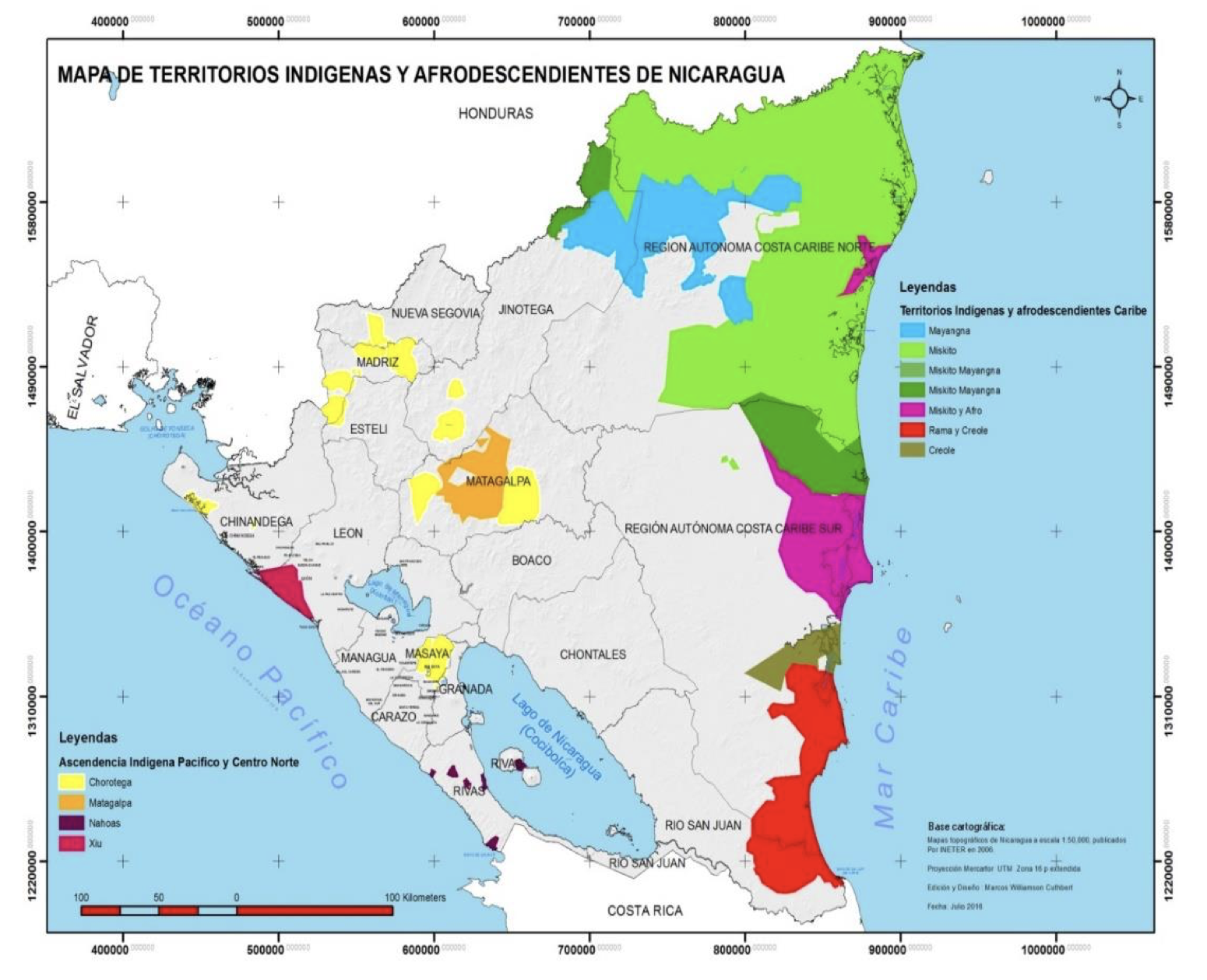
Dispossesions in the Americas

Dispossesions in the Americas

  • Inicio
  • Explorar
  • Autores
  • Sobre
  • Arte
  • Cuerpos
  • Planes de Estudio
  • Herencia Cultural
  • Mapas
  • Territorios
Volver a Explorar

Leyendo en Inglés

Mapa 1787

Mosquitia or The Mosquito Shore with The Eastern Part of Yucatán as far as the 20th Degree of North Latitude

  • FADEN, WILLIAM

Publicado: 1787

  • Descargar Imágen
  • Descargar Imágen
Mapa 1787

Mosquitia or The Mosquito Shore with The Eastern Part of Yucatán as far as the 20th Degree of North Latitude

  • FADEN, WILLIAM

Publicado: 1787

  • Descargar Imágen

Pueblos

  • MOSQUITOS
  • SAMBOS
  • PANAMACAS
  • TOWACAS
  • WOOLWAS
  • CACKERAS
  • RAMAS
  • HICACAS

Citas

Faden, William. "Mosquitia or The Mosquito Shore with The Eastern Part of Yucatan as far as the 20th Degree of North Latitude." Map. 1787. Accessed August 10, 2023. https://gallica.bnf.fr/ark:/12148/btv1b59707927/f1.item.r=Honduras.

  • Descargar Imágen

Artículos Relacionados

AMER. MÈR. PARTIE DE LA PLATA. N. 31.

AMER. MÈR. PARTIE DE LA PLATA. N. 31.

Mapa 1825
The Spanish and Musketor shore and the bay of Honduras and the islands adjacent

The Spanish and Musketor shore and the bay of Honduras and the islands adjacent

Mapa 1735
Map of El Salvador with Specific indigenous communities in El Salvador, and the archaeological zone of Chalchuapa in western El Salvador. The Department of San Vicente is also highlighted.

Map of El Salvador with Specific indigenous communities in El Salvador, and the archaeological zone of Chalchuapa in western El Salvador. The Department of San Vicente is also highlighted.

Mapa 2010
Chile: Desierto de Atacama

Chile: Desierto de Atacama

Mapa 1854
A New Map of Mexico and Adjacent Provinces Compiled From Original Documents

A New Map of Mexico and Adjacent Provinces Compiled From Original Documents

Mapa 1810
IL PARAGUAI E PARTE DEI PAESI ADIACENT

IL PARAGUAI E PARTE DEI PAESI ADIACENT

Mapa 1785
Property Ownership in 1900, Verapaz Guatemala

Property Ownership in 1900, Verapaz Guatemala

Mapa 1900
Outlines of the physical and political division of South America: Delineated by A. Arrowsmith partly from scarce and original documents, published before the year 1806 but principally from manuscript maps & surveys made between the years 1771 and 1806, corrected from accurate astronomical observations to 1810.

Outlines of the physical and political division of South America: Delineated by A. Arrowsmith partly from scarce and original documents, published before the year 1806 but principally from manuscript maps & surveys made between the years 1771 and 1806, corrected from accurate astronomical observations to 1810.

Mapa 1800 - 1899

Despojos en las Américas

Un Proyecto de

University of Pennsylvania

Copyright 2024

Con el apoyo de

Mellon Foundation

Diseño y Desarrollo del Sitio

Element 84

Créditos Artísticos

Faden, William. “Mosquitia or The Mosquito Shore with The Eastern Part of Yucatan as far as the 20th Degree of North Latitude.” Map. 1787. Accessed August 10, 2023. https://gallica.bnf.fr/ark:/12148/btv1b59707927/f1.item.r=Honduras.

Páginas del Sitio

  • Inicio
  • Explorar
  • Autores
  • Sobre
  • Arte
  • Cuerpos
  • Planes de Estudio
  • Herencia Cultural
  • Mapas
  • Territorios