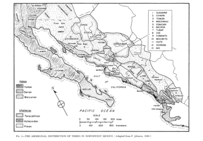
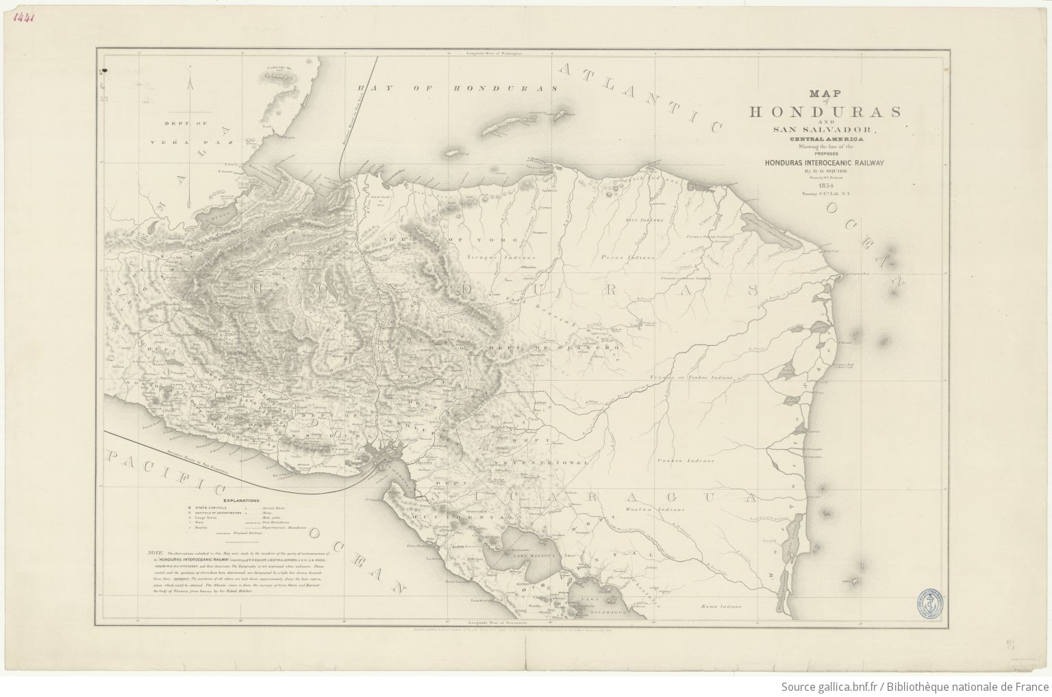
Dispossesions in the Americas

Dispossesions in the Americas

  • Inicio
  • Explorar
  • Autores
  • Sobre
  • Arte
  • Cuerpos
  • Planes de Estudio
  • Herencia Cultural
  • Mapas
  • Territorios
Volver a Explorar

Leyendo en Inglés

Mapa 1854

Map of Honduras and San Salvador, Central America, Showing the line of the proposed Honduras Interoceanic Railway

  • SQUIER, EPHRAIM GEORGE;HITCHCOCK, D.C.

Publicado: 1854

  • Descargar Imágen
  • Descargar Imágen
Mapa 1854

Map of Honduras and San Salvador, Central America, Showing the line of the proposed Honduras Interoceanic Railway

  • SQUIER, EPHRAIM GEORGE;HITCHCOCK, D.C.

Publicado: 1854

  • Descargar Imágen

Pueblos

  • XICAQUE
  • THUACOS
  • JUACOS
  • CARIB
  • SECO
  • POYAS
  • PAYAS
  • SAMBOS
  • TOACAS
  • TOWKAS
  • COOKRA
  • WOOLWA
  • RAMA
  • CHONTALES

Citas

Squier, E.G. Map of Honduras and San Salvador, Central America, Showing the line of the proposed Honduras Interoceanic Railway. Map. New York, USA, 1854. Accessed August 10, 2023. https://gallica.bnf.fr/ark:/12148/btv1b53171836z/f1.item.r=Honduras.zoom#.

  • Descargar Imágen

Artículos Relacionados

No Title

No Title

Mapa -2500 - 1520
MAPPA DO IMPERIO DO BRAZIL

MAPPA DO IMPERIO DO BRAZIL

Mapa 1878
The Southern Maya Lowlands during the Sixteenth and Seventeenth Centuries

The Southern Maya Lowlands during the Sixteenth and Seventeenth Centuries

Mapa 1500 - 1700
Sur de Mesamérica alrededor del siglo XVII con los grupos lingüísticos

Sur de Mesamérica alrededor del siglo XVII con los grupos lingüísticos

Mapa 1800 - 1900
Sierra Tarahumara Study Area - Online GIS

Sierra Tarahumara Study Area - Online GIS

Mapa 2005
EL TERRITORIO AYOREO EN EL MAPA DE PARAGUAY HOY

EL TERRITORIO AYOREO EN EL MAPA DE PARAGUAY HOY

Mapa 2010
Stone Butch

Stone Butch

Obra de Arte
Guiana verdeelt in Guiana en Caribana. door N. Sanson d.'Abbeville, Geogr ordre. du Roÿ

Guiana verdeelt in Guiana en Caribana. door N. Sanson d.'Abbeville, Geogr ordre. du Roÿ

Mapa 1600 - 1699

Despojos en las Américas

Un Proyecto de

University of Pennsylvania

Copyright 2024

Con el apoyo de

Mellon Foundation

Diseño y Desarrollo del Sitio

Element 84

Créditos Artísticos

Squier, E.G. Map of Honduras and San Salvador, Central America, Showing the line of the proposed Honduras Interoceanic Railway. Map. New York, USA, 1854. Accessed August 10, 2023. https://gallica.bnf.fr/ark:/12148/btv1b53171836z/f1.item.r=Honduras.zoom#.

Páginas del Sitio

  • Inicio
  • Explorar
  • Autores
  • Sobre
  • Arte
  • Cuerpos
  • Planes de Estudio
  • Herencia Cultural
  • Mapas
  • Territorios