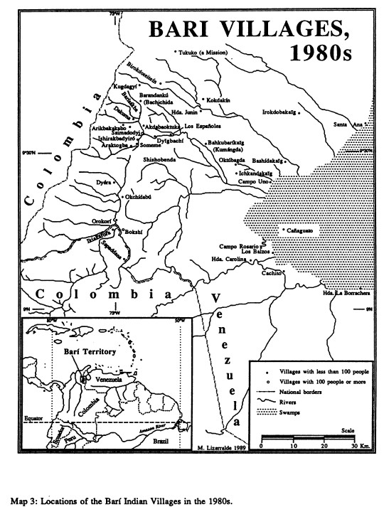
Pueblos- MUSCHETO
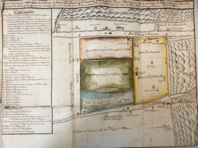
CitasUring, Nathaniel. An exact draught of the river of Bellese as high as the Barcadares. A new draught of the bay of Honduras by Capt. Nathaniel Uring. Map. London, England: W. Wilkins, 1726. Accessed July 14, 2023. https://jcb.lunaimaging.com/luna/servlet/detail/JCBMAPS~1~1~4799~102886:An-exact-draught-of-the-river-of-Be?sort=normalized_date%2Cfile_name%2Csource_author%2Csource_title&qvq=q:an%20exact%20draught%20of%20the%20river;sort:normalized_date%2Cfile_name%2Csource_author%2Csource_title;lc:JCBMAPS~1~1&mi=1&trs=3.
Uring, Nathaniel. An exact draught of the river of Bellese as high as the Barcadares. A new draught of the bay of Honduras by Capt. Nathaniel Uring. Map. London, England: W. Wilkins, 1726. Accessed July 14, 2023. https://jcb.lunaimaging.com/luna/servlet/detail/JCBMAPS~1~1~4799~102886:An-exact-draught-of-the-river-of-Be?sort=normalized_date%2Cfile_name%2Csource_author%2Csource_title&qvq=q:an%20exact%20draught%20of%20the%20river;sort:normalized_date%2Cfile_name%2Csource_author%2Csource_title;lc:JCBMAPS~1~1&mi=1&trs=3.