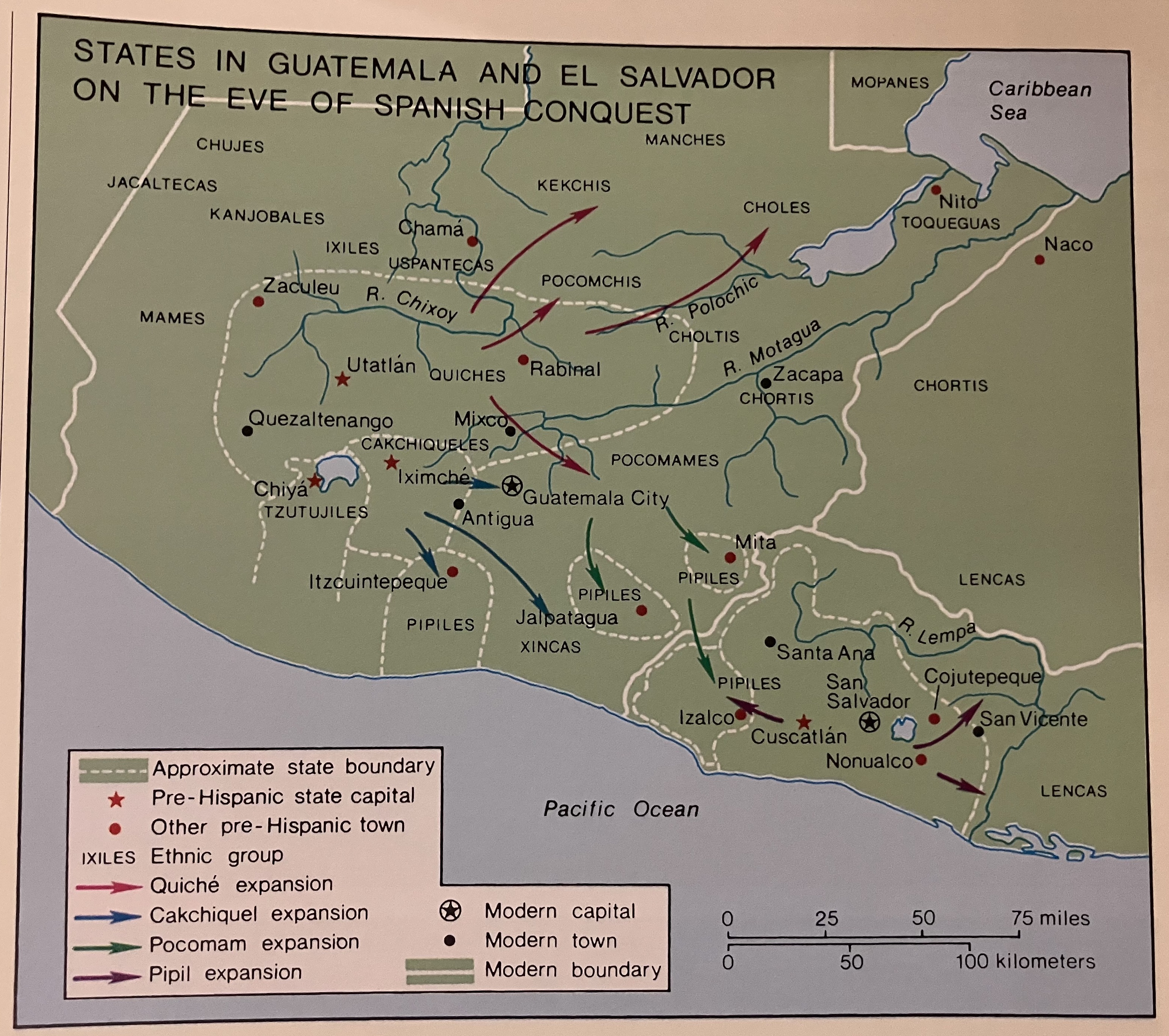
Dispossesions in the Americas

Dispossesions in the Americas

  • Inicio
  • Explorar
  • Autores
  • Sobre
  • Arte
  • Cuerpos
  • Planes de Estudio
  • Herencia Cultural
  • Mapas
  • Territorios
Volver a Explorar

Leyendo en Inglés

Mapa 1524

States in Guatemala and el Salvador on the Eve of Spanish Conquest.

  • COTTER, JAMES

Publicado: 2003

  • Descargar Imágen
  • Descargar Imágen
Mapa 1524

States in Guatemala and el Salvador on the Eve of Spanish Conquest.

  • COTTER, JAMES

Publicado: 2003

  • Descargar Imágen

Pueblos

  • MANCHES
  • KEKCHIS
  • CHOLES
  • CHUJES
  • JACALTECAS
  • KANJOBALES
  • IXILES
  • MAMES
  • TZUTUJILES
  • PIPILES
  • XINCAS
  • CHORTIS
  • POCOMAM
  • TOQUEGUAS

Cita

Cotter, John. "States in Guatemala and el Salvador on the Eve of Spanish Conquest." In Hall, Carolyn and Héctor Pérez Brignoli, Historical Atlas of Central America. Norman, University of California Press, 2003.

  • Descargar Imágen

Leyendo en Portugués

Mapa 1524

States in Guatemala and el Salvador on the Eve of Spanish Conquest.

  • COTTER, JAMES

Publicado: 2003

  • Descargar Imágen

Pueblos

  • MANCHES
  • KEKCHIS
  • CHOLES
  • CHUJES
  • JACALTECAS
  • KANJOBALES
  • IXILES
  • MAMES
  • TZUTUJILES
  • PIPILES
  • XINCAS
  • CHORTIS
  • POCOMAM
  • TOQUEGUAS

Cita

Cotter, John. "States in Guatemala and el Salvador on the Eve of Spanish Conquest." In Hall, Carolyn and Héctor Pérez Brignoli, Historical Atlas of Central America. Norman, University of California Press, 2003.

  • Descargar Imágen

Artículos Relacionados

PUEBLOS CHIBCHAS ENCONTRADOS POR CONQUISTADORES

PUEBLOS CHIBCHAS ENCONTRADOS POR CONQUISTADORES

Mapa 1399
INTENDENCIA DE DURANGO

INTENDENCIA DE DURANGO

Mapa 1800
CARACCAS AND GUIANA

CARACCAS AND GUIANA

Mapa 1814
Mapa de la Republica de Nicaragua y parte de las de Honduras y Costa Rica Continiendo los mejores datos conocidos hasta 1873

Mapa de la Republica de Nicaragua y parte de las de Honduras y Costa Rica Continiendo los mejores datos conocidos hasta 1873

Mapa 1800 - 1873
Population density of Cuba

Population density of Cuba

Mapa -4000
REGIÓN HUASTECA

REGIÓN HUASTECA

Mapa 2000
Il Chili con le contrade vicine ed il Paese dei Patagoni

Il Chili con le contrade vicine ed il Paese dei Patagoni

Mapa 1700 - 1800
A draft of the Golden and adjacent islands

A draft of the Golden and adjacent islands

Mapa 1688

Despojos en las Américas

Un Proyecto de

University of Pennsylvania

Copyright 2024

Con el apoyo de

Mellon Foundation

Diseño y Desarrollo del Sitio

Element 84

Créditos Artísticos

Cotter, John. “States in Guatemala and el Salvador on the Eve of Spanish Conquest.” In Hall, Carolyn and Héctor Pérez Brignoli, Historical Atlas of Central America. Norman, University of California Press, 2003.

Páginas del Sitio

  • Inicio
  • Explorar
  • Autores
  • Sobre
  • Arte
  • Cuerpos
  • Planes de Estudio
  • Herencia Cultural
  • Mapas
  • Territorios