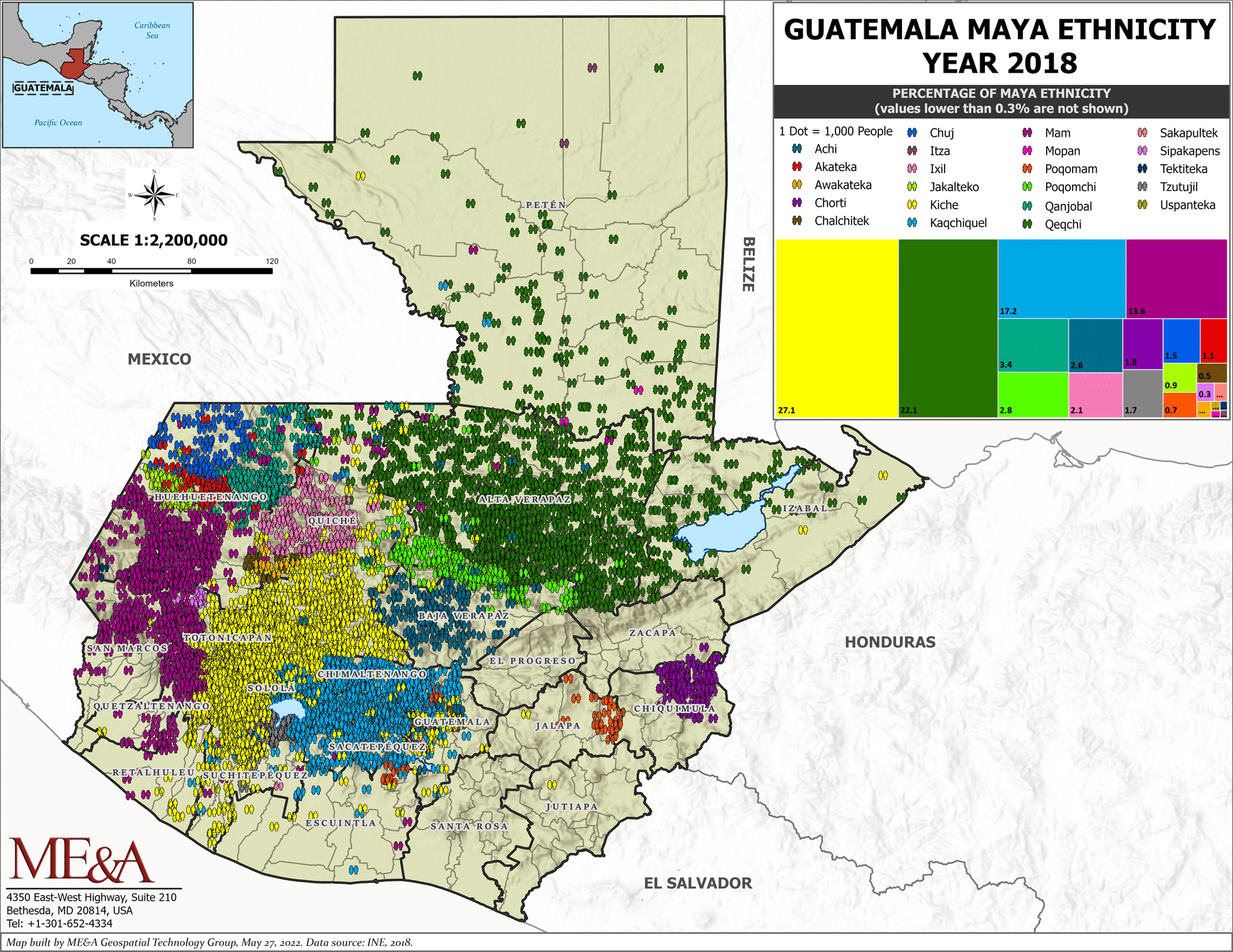
Dispossesions in the Americas

Dispossesions in the Americas

  • Inicio
  • Explorar
  • Autores
  • Sobre
  • Arte
  • Cuerpos
  • Planes de Estudio
  • Herencia Cultural
  • Mapas
  • Territorios
Volver a Explorar

Leyendo en Inglés

Mapa 2000

Guatemala Maya Ethnicity Year 2018

  • ME&A Geospatial Technology Group

Publicado: 2018

  • Descargar Imágen
  • Descargar Imágen
Mapa 2000

Guatemala Maya Ethnicity Year 2018

  • ME&A Geospatial Technology Group

Publicado: 2018

  • Descargar Imágen

Pueblos

  • ACHI
  • AKATEKA
  • AWAKATEKA
  • CHORTI
  • CHALCHITEK
  • CHUJ
  • ITZA
  • IXIL
  • JAKALTEKO
  • KICHE
  • KAQCHIQUEL
  • MAM
  • MOPAN
  • POQOMAM
  • POQOMCHI
  • QANJOBAL
  • QEQCHI
  • SAKAPULTEK
  • SIPAKEPENS
  • TEKTITEKA
  • TZUTUJIL
  • USPANTEKA

Cita

Guatemala Maya Ethnicity Year 2018. ME&A Geospatial Technology Group. May built in May 2022. Data Source: INE 2018. https://www.meandahq.com/esri-conference-features-mea-produced-maps-on-guatemalan-mayan-communities/

  • Descargar Imágen

Leyendo en Portugués

Mapa 2000

Guatemala Maya Ethnicity Year 2018

  • ME&A Geospatial Technology Group

Publicado: 2018

  • Descargar Imágen

Pueblos

  • ACHI
  • AKATEKA
  • AWAKATEKA
  • CHORTI
  • CHALCHITEK
  • CHUJ
  • ITZA
  • IXIL
  • JAKALTEKO
  • KICHE
  • KAQCHIQUEL
  • MAM
  • MOPAN
  • POQOMAM
  • POQOMCHI
  • QANJOBAL
  • QEQCHI
  • SAKAPULTEK
  • SIPAKEPENS
  • TEKTITEKA
  • TZUTUJIL
  • USPANTEKA

Cita

Guatemala Maya Ethnicity Year 2018. ME&A Geospatial Technology Group. May built in May 2022. Data Source: INE 2018. https://www.meandahq.com/esri-conference-features-mea-produced-maps-on-guatemalan-mayan-communities/

  • Descargar Imágen

Artículos Relacionados

A New Map of Mexico and Adjacent Provinces Compiled From Original Documents

A New Map of Mexico and Adjacent Provinces Compiled From Original Documents

Mapa 1810
2. THE JIBARO TRIBES

2. THE JIBARO TRIBES

Mapa 1976 - 1978
PUEBLO AMUZGO

PUEBLO AMUZGO

Mapa 2020
CARTA del CANTON DE UPATA de la Provincia de GUAYANA

CARTA del CANTON DE UPATA de la Provincia de GUAYANA

Mapa 1840
FRAGMENTO HUMBOLDT 2

FRAGMENTO HUMBOLDT 2

Mapa 1500 - 1599
DISTRIBUCIÓN DE LOS GRUPOS INDÍGENAS EN EL SIGLO XVI

DISTRIBUCIÓN DE LOS GRUPOS INDÍGENAS EN EL SIGLO XVI

Mapa 1500 - 1599
Detail from the 1770 copy of Francisco Álvarez Barreiro’s 1728 map of northern New Spain illustrating Spanish mapping of Indian domains in southern Texas and along the Gulf Coast, especially through the repetition of labels: “tierra de los Pampopas,” “tierra de los Carrizos,” “tierra de los Cujanes,” etc.

Detail from the 1770 copy of Francisco Álvarez Barreiro’s 1728 map of northern New Spain illustrating Spanish mapping of Indian domains in southern Texas and along the Gulf Coast, especially through the repetition of labels: “tierra de los Pampopas,” “tierra de los Carrizos,” “tierra de los Cujanes,” etc.

Mapa 1728
Paraguay Tribal Map

Paraguay Tribal Map

Mapa

Despojos en las Américas

Un Proyecto de

University of Pennsylvania

Copyright 2024

Con el apoyo de

Mellon Foundation

Diseño y Desarrollo del Sitio

Element 84

Créditos Artísticos

Guatemala Maya Ethnicity Year 2018. ME&A Geospatial Technology Group. May built in May 2022. Data Source: INE 2018. https://www.meandahq.com/esri-conference-features-mea-produced-maps-on-guatemalan-mayan-communities/

Páginas del Sitio

  • Inicio
  • Explorar
  • Autores
  • Sobre
  • Arte
  • Cuerpos
  • Planes de Estudio
  • Herencia Cultural
  • Mapas
  • Territorios