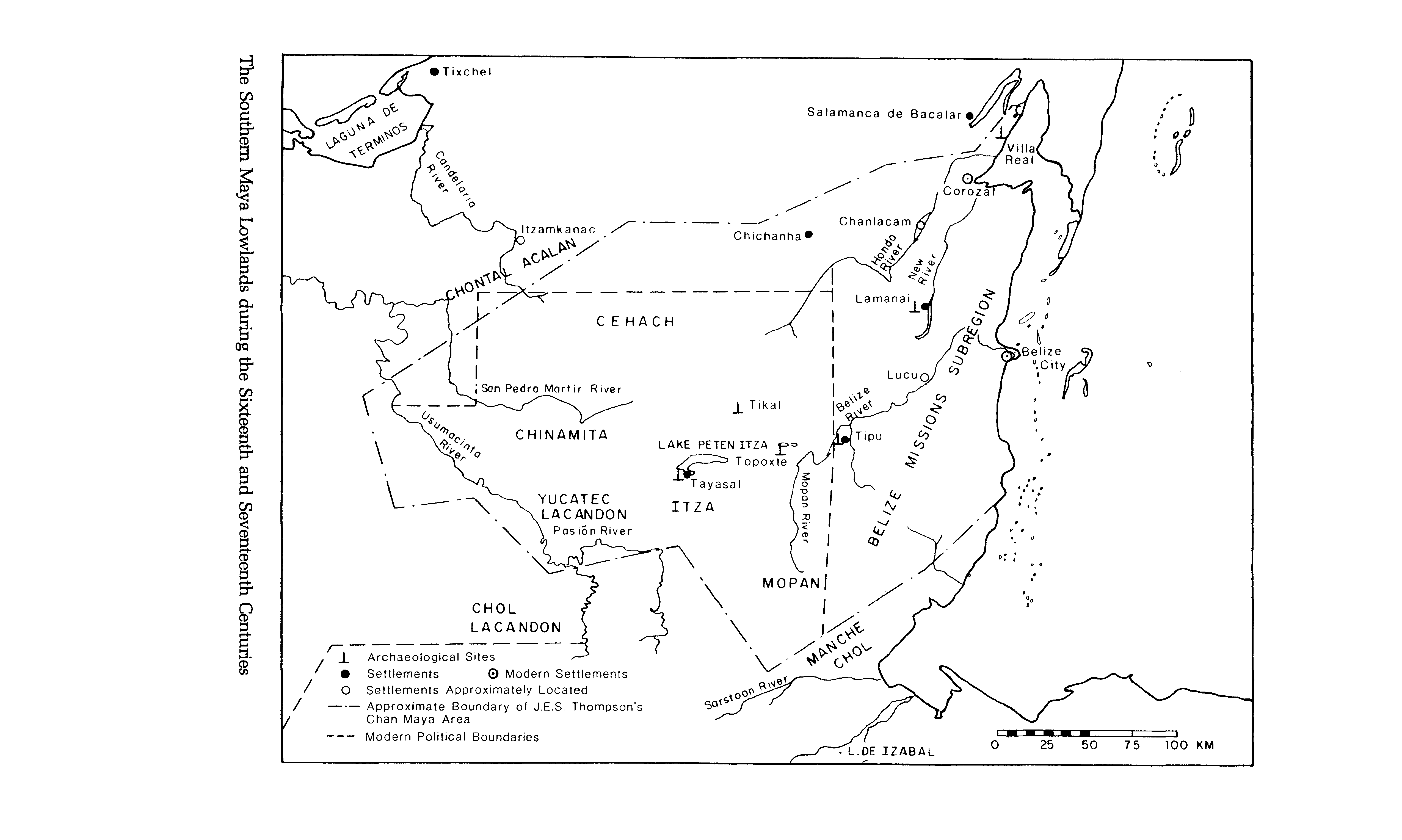
Dispossesions in the Americas

Dispossesions in the Americas

  • Inicio
  • Explorar
  • Autores
  • Sobre
  • Arte
  • Cuerpos
  • Planes de Estudio
  • Herencia Cultural
  • Mapas
  • Territorios
Volver a Explorar

Leyendo en Inglés

Mapa 1500 - 1700

The Southern Maya Lowlands during the Sixteenth and Seventeenth Centuries

    • Descargar Imágen
    • Descargar Imágen
    Mapa 1500 - 1700

    The Southern Maya Lowlands during the Sixteenth and Seventeenth Centuries

      • Descargar Imágen

      Pueblos

      • MANCHECHOL
      • MOPAN
      • ITZA
      • CHOL LACANDON
      • YUCATEC LACANDON
      • CHINAMITA
      • CEHACH
      • CHONTALACALAN

      Cita

      MacLeod, Murdo J. Spaniards and Indians In Southeastern Mesoamerica: Essays On the History of Ethnic Relations. Lincoln: University of Nebraska Press, 1983. https://hdl-handle-net.proxy.library.upenn.edu/2027/heb.03660.EPUB.

      • Descargar Imágen

      Leyendo en Portugués

      Mapa 1500 - 1700

      The Southern Maya Lowlands during the Sixteenth and Seventeenth Centuries

        • Descargar Imágen

        Pueblos

        • MANCHECHOL
        • MOPAN
        • ITZA
        • CHOL LACANDON
        • YUCATEC LACANDON
        • CHINAMITA
        • CEHACH
        • CHONTALACALAN

        Cita

        MacLeod, Murdo J. Spaniards and Indians In Southeastern Mesoamerica: Essays On the History of Ethnic Relations. Lincoln: University of Nebraska Press, 1983. https://hdl-handle-net.proxy.library.upenn.edu/2027/heb.03660.EPUB.

        • Descargar Imágen

        Artículos Relacionados

        Empire du BRÉSIL

        Empire du BRÉSIL

        Mapa 1835
        Provinces depéndant de la triple alliance

        Provinces depéndant de la triple alliance

        Mapa
        Tenencia de Tierra en la Isla de Pascua hacia 1871.

        Tenencia de Tierra en la Isla de Pascua hacia 1871.

        Mapa 1871
        SPECIAL MAP OF BRITISH GUIANA Illustrating the VENEZUELA-GUIANA BOUNDARY DISPUTE

        SPECIAL MAP OF BRITISH GUIANA Illustrating the VENEZUELA-GUIANA BOUNDARY DISPUTE

        Mapa 1898
        Map of the Mayance Nations and Languages

        Map of the Mayance Nations and Languages

        Mapa 1000 - 1500
        Guyanes. Amér. Mérid. no. 7. (Dresse par Ph. Vandermaelen, lithographie par H. Ode. Cinquième partie. - Amer. merid. Bruxelles. 1827)

        Guyanes. Amér. Mérid. no. 7. (Dresse par Ph. Vandermaelen, lithographie par H. Ode. Cinquième partie. - Amer. merid. Bruxelles. 1827)

        Mapa 1800 - 1899
        CARTA COROGRAFICA DE LA REPÚBLICA DEL ECUADOR / MANUEL VILLAVICENCIO ;LIT. E IMP. DE F. MAYER Y CA.

        CARTA COROGRAFICA DE LA REPÚBLICA DEL ECUADOR / MANUEL VILLAVICENCIO ;LIT. E IMP. DE F. MAYER Y CA.

        Mapa 1817
        PLANO DE LAS TIERRAS DE SAYAUSÍ;EN CUENCA QUE SE ADJUNTA AL PROCESO PROMOVIDO POR NICOLÁS COBOS CONTRA MANUEL TACURI SOBRE TIERRAS DENOMIDAS MAPÁN

        PLANO DE LAS TIERRAS DE SAYAUSÍ;EN CUENCA QUE SE ADJUNTA AL PROCESO PROMOVIDO POR NICOLÁS COBOS CONTRA MANUEL TACURI SOBRE TIERRAS DENOMIDAS MAPÁN

        Mapa 1761

        Despojos en las Américas

        Un Proyecto de

        University of Pennsylvania

        Copyright 2024

        Con el apoyo de

        Mellon Foundation

        Diseño y Desarrollo del Sitio

        Element 84

        Créditos Artísticos

        MacLeod, Murdo J. Spaniards and Indians In Southeastern Mesoamerica: Essays On the History of Ethnic Relations. Lincoln: University of Nebraska Press, 1983. https://hdl-handle-net.proxy.library.upenn.edu/2027/heb.03660.EPUB.

        Páginas del Sitio

        • Inicio
        • Explorar
        • Autores
        • Sobre
        • Arte
        • Cuerpos
        • Planes de Estudio
        • Herencia Cultural
        • Mapas
        • Territorios