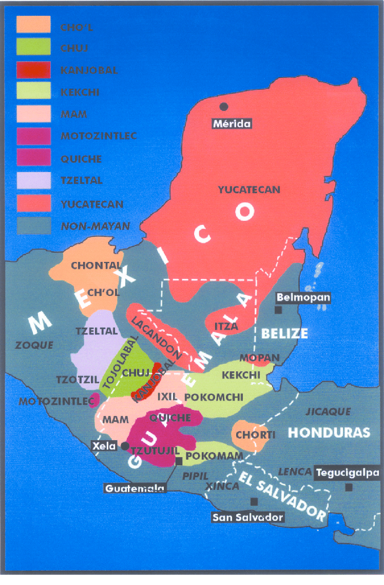
Dispossesions in the Americas

Dispossesions in the Americas

  • Inicio
  • Explorar
  • Autores
  • Sobre
  • Arte
  • Cuerpos
  • Planes de Estudio
  • Herencia Cultural
  • Mapas
  • Territorios
Volver a Explorar

Leyendo en Inglés

Mapa

Origin of Mayans according to HLA genes and the uniqueness

  • GOMEZ-CASADO, EDUARDO, ET AL.

Publicado: 2003

  • Descargar Imágen
  • Descargar Imágen
Mapa

Origin of Mayans according to HLA genes and the uniqueness

  • GOMEZ-CASADO, EDUARDO, ET AL.

Publicado: 2003

  • Descargar Imágen

Pueblos

  • YUCATECAN
  • CHONTAL
  • CHOL
  • ITZA
  • LANCANDON
  • TZELTAL
  • ZOQUE
  • TZOTZIL
  • TOJOLABAL
  • CHUJ
  • MOTOZINTLEC
  • KANJOBAL
  • MAM
  • IXIL
  • MOPAN
  • KEKCHI
  • POKOMCHI
  • QUICHE
  • TZUTUJIL
  • POKOMAM
  • CHORTI
  • PIPIL
  • XINCA
  • JICAQUE
  • LENCA

Citas

Gomez-Casado, Eduardo, Jorge Martinez-Laso, Juan Moscoso del Prado Ucelay, Joseph Zamora, José M. Martin-Villa, Mercedes Perez-Blas, Mercedes Lopez-Santalla, P. Lucas Gramajo, Carlos Silvera, Ernesto Lowy, and Antonio Arnaiz-Villena. "Origin of Mayans according to HLA genes and the uniqueness of Amerindians." Research Gate. Last modified July 2003. Accessed October 2, 2021. https://www.researchgate.net/figure/Map-showing-the-geographic-location-of-the-Mayan-population-studied-and-Mayan-languages_fig1_10693028.

  • Descargar Imágen

Artículos Relacionados

PLANO DEL HATO DEL TAMBO;ADJUNTO A LA ESCRITURA DE DONACIÓN QUE OTORGA PABLO CHIRIBOGA A FAVOR DE LOS INDÍGENAS DE PAPALLACTA

PLANO DEL HATO DEL TAMBO;ADJUNTO A LA ESCRITURA DE DONACIÓN QUE OTORGA PABLO CHIRIBOGA A FAVOR DE LOS INDÍGENAS DE PAPALLACTA

Mapa 1903
IDIOMAS DE GUATEMALA Y BELICE

IDIOMAS DE GUATEMALA Y BELICE

Mapa
Carte de la Goÿanne francoise depuis le fort de Barou et la Rre. D'yari, jusqua Maroni ou on voit les principaux établissements des Francois tant das l'isle de Caÿenne que dans la terre ferme, avec les noms des nations indienne qui habitent et les missions que le RR.PP y ont établies.

Carte de la Goÿanne francoise depuis le fort de Barou et la Rre. D'yari, jusqua Maroni ou on voit les principaux établissements des Francois tant das l'isle de Caÿenne que dans la terre ferme, avec les noms des nations indienne qui habitent et les missions que le RR.PP y ont établies.

Mapa 1741
CONCENTRACIÓN DE POBLACION DE TRES Y MAS ANOS QUE HABLAN LENGUA INDÍGENA EN MÉRIDA, YUCATÁN, 2010

CONCENTRACIÓN DE POBLACION DE TRES Y MAS ANOS QUE HABLAN LENGUA INDÍGENA EN MÉRIDA, YUCATÁN, 2010

Mapa 2012
Obispado de Tlaxcala

Obispado de Tlaxcala

Mapa 1500 - 1599
PUEBLO KIKAPU

PUEBLO KIKAPU

Mapa 2020
The indigenous language groups  of Baja California at contact

The indigenous language groups of Baja California at contact

Mapa 1530
COMUNIDADES Y TERRITORIOS DEL PUEBLO WOUNAAN

COMUNIDADES Y TERRITORIOS DEL PUEBLO WOUNAAN

Mapa 2012

Despojos en las Américas

Un Proyecto de

University of Pennsylvania

Copyright 2024

Con el apoyo de

Mellon Foundation

Diseño y Desarrollo del Sitio

Element 84

Créditos Artísticos

Gomez-Casado, Eduardo, Jorge Martinez-Laso, Juan Moscoso del Prado Ucelay, Joseph Zamora, José M. Martin-Villa, Mercedes Perez-Blas, Mercedes Lopez-Santalla, P. Lucas Gramajo, Carlos Silvera, Ernesto Lowy, and Antonio Arnaiz-Villena. “Origin of Mayans according to HLA genes and the uniqueness of Amerindians.” Research Gate. Last modified July 2003. Accessed October 2, 2021. https://www.researchgate.net/figure/Map-showing-the-geographic-location-of-the-Mayan-population-studied-and-Mayan-languages_fig1_10693028.

Páginas del Sitio

  • Inicio
  • Explorar
  • Autores
  • Sobre
  • Arte
  • Cuerpos
  • Planes de Estudio
  • Herencia Cultural
  • Mapas
  • Territorios