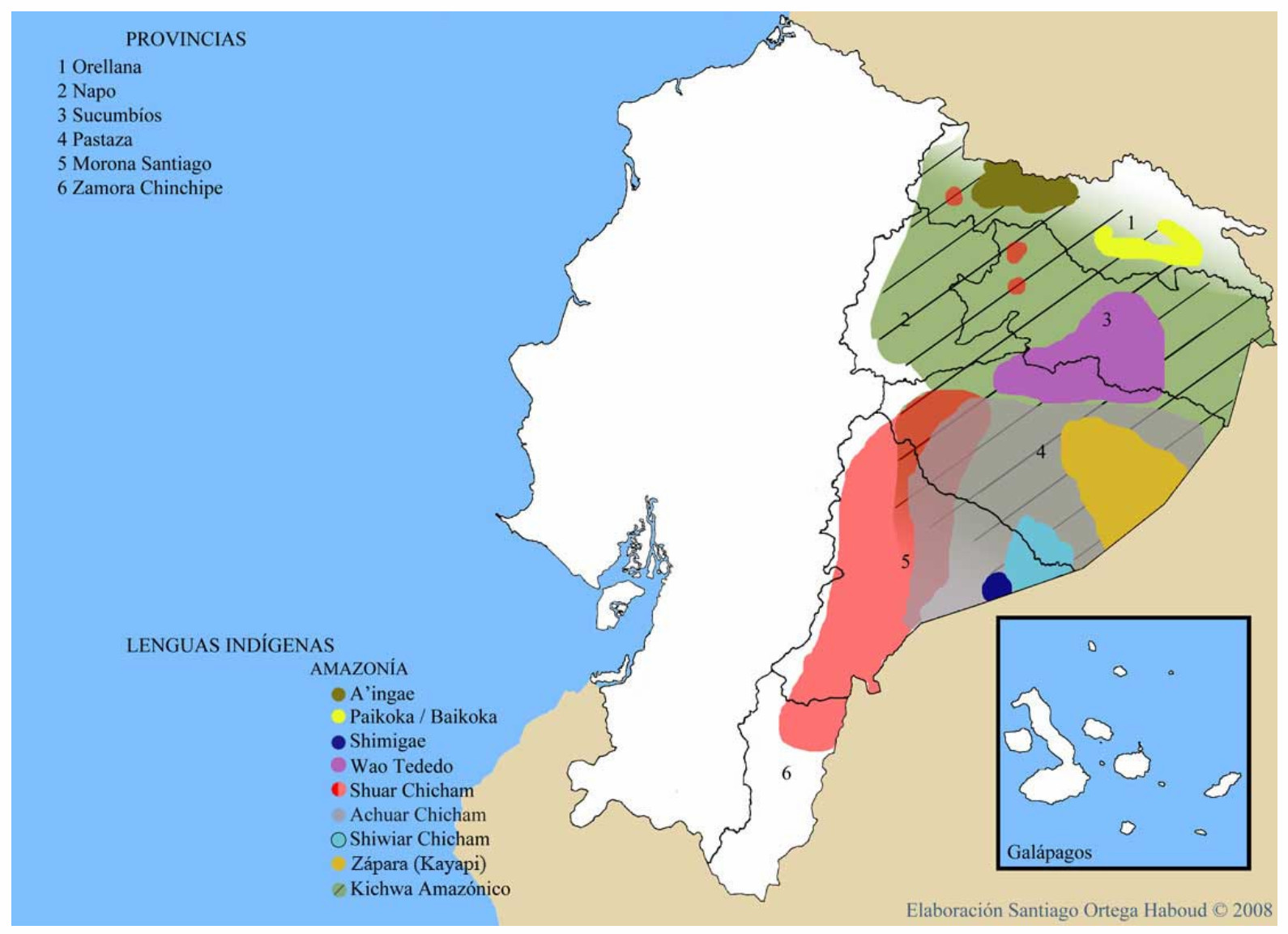
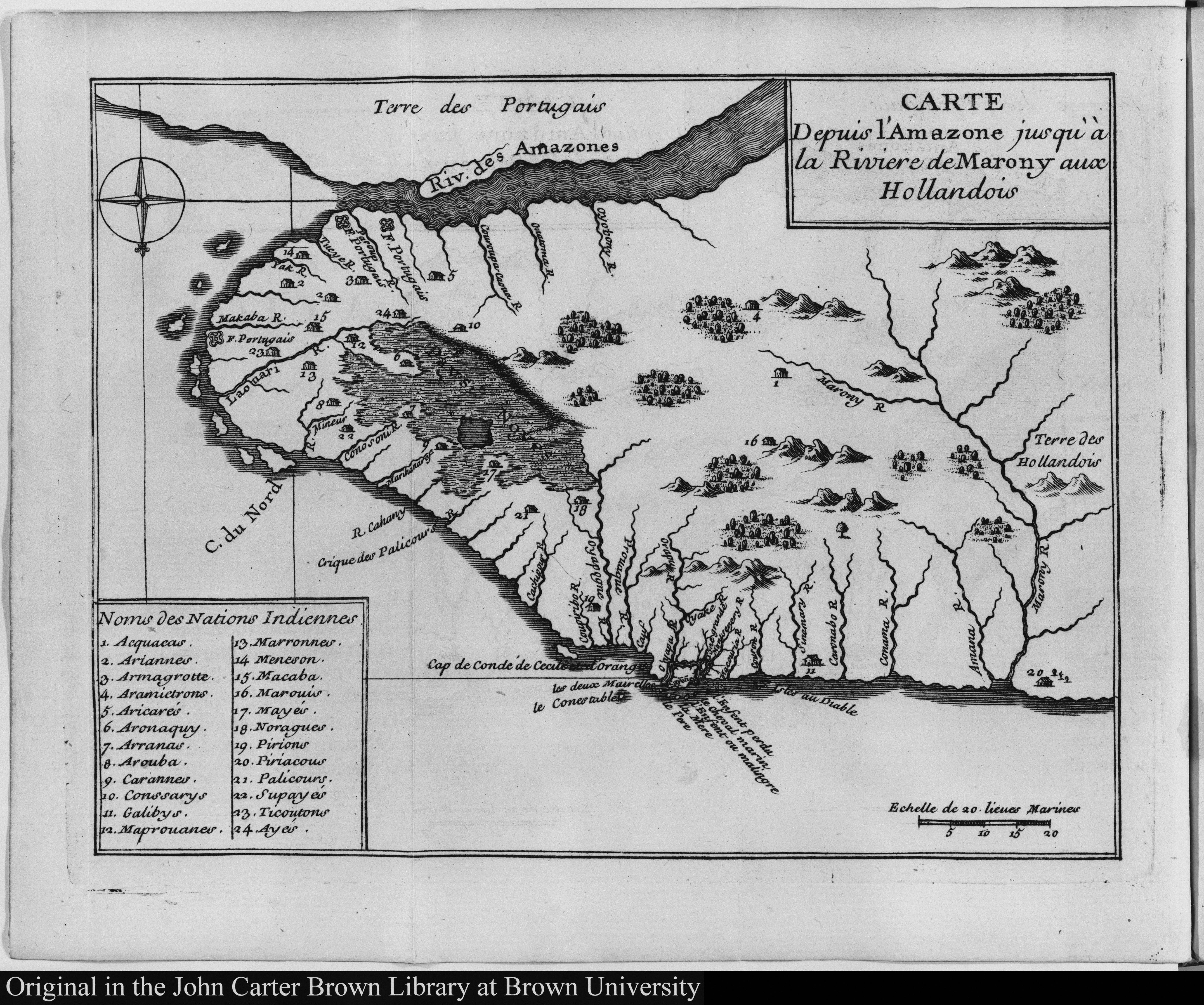
Dispossesions in the Americas

Dispossesions in the Americas

  • Inicio
  • Explorar
  • Autores
  • Sobre
  • Arte
  • Cuerpos
  • Planes de Estudio
  • Herencia Cultural
  • Mapas
  • Territorios
Volver a Explorar

Leyendo en Inglés

Mapa 1743

Carte Depuis l'Amazone jusqu'à la Riviere de Marony aux Hollandois.

  • PIGET;DAMONNEVILLE;DURAND

Publicado: 1743

  • Descargar Imágen
  • Descargar Imágen
Mapa 1743

Carte Depuis l'Amazone jusqu'à la Riviere de Marony aux Hollandois.

  • PIGET;DAMONNEVILLE;DURAND

Publicado: 1743

  • Descargar Imágen

Pueblos

  • ACQUACAS
  • ARIANNES
  • ARMAGROTTE
  • ARAMIETRONS
  • ARICARES
  • ARONAQUY
  • ARRANAS
  • AROUBA
  • AYES
  • CARANNES
  • CONSSARYS
  • GALIBYS
  • MAPROUANES
  • MARRONES
  • MENESON
  • MACABA
  • MAROUIS
  • MAYES
  • NORAGUES
  • PIRIONS
  • PIRIACOUS
  • PALICOURS
  • SUPAYES
  • TICOUTONS

Cita

Carte Depuis l'Amazone jusqu'à la Riviere de Marony aux Hollandois. The JCB Library. Accessed, August 16, 2023. https://jcb.lunaimaging.com/luna/servlet/detail/JCBMAPS~1~1~1485~101220018

  • Descargar Imágen

Leyendo en Portugués

Mapa 1743

Carte Depuis l'Amazone jusqu'à la Riviere de Marony aux Hollandois.

  • PIGET;DAMONNEVILLE;DURAND

Publicado: 1743

  • Descargar Imágen

Pueblos

  • ACQUACAS
  • ARIANNES
  • ARMAGROTTE
  • ARAMIETRONS
  • ARICARES
  • ARONAQUY
  • ARRANAS
  • AROUBA
  • AYES
  • CARANNES
  • CONSSARYS
  • GALIBYS
  • MAPROUANES
  • MARRONES
  • MENESON
  • MACABA
  • MAROUIS
  • MAYES
  • NORAGUES
  • PIRIONS
  • PIRIACOUS
  • PALICOURS
  • SUPAYES
  • TICOUTONS

Cita

Carte Depuis l'Amazone jusqu'à la Riviere de Marony aux Hollandois. The JCB Library. Accessed, August 16, 2023. https://jcb.lunaimaging.com/luna/servlet/detail/JCBMAPS~1~1~1485~101220018

  • Descargar Imágen

Artículos Relacionados

Map of the North Atlantic Autonomous Region (RAAN);Northeastern Nicaragua.

Map of the North Atlantic Autonomous Region (RAAN);Northeastern Nicaragua.

Mapa 1900
Mixe Towns

Mixe Towns

Mapa 1969
Map of the basin of La Plata : based upon the results of the expedition under the command of Thos. J. Page;U.S. Navy;in the years 1853;-'54;-'55;& 56 and of the adjacent countries

Map of the basin of La Plata : based upon the results of the expedition under the command of Thos. J. Page;U.S. Navy;in the years 1853;-'54;-'55;& 56 and of the adjacent countries

Mapa 1853 - 1856
REGIÓN NORTE DE CHIAPAS

REGIÓN NORTE DE CHIAPAS

Mapa 2000
LENGUAS INDIGENAS AMAZONIA

LENGUAS INDIGENAS AMAZONIA

Mapa 2008
Linea de frontera contra los indios

Linea de frontera contra los indios

Mapa 1779 - 1829
Haush

Haush

Mapa 1800
INTENDENCIA DE DURANGO

INTENDENCIA DE DURANGO

Mapa 1800

Despojos en las Américas

Un Proyecto de

University of Pennsylvania

Copyright 2024

Con el apoyo de

Mellon Foundation

Diseño y Desarrollo del Sitio

Element 84

Créditos Artísticos

Carte Depuis l’Amazone jusqu’à la Riviere de Marony aux Hollandois. The JCB Library. Accessed, August 16, 2023. https://jcb.lunaimaging.com/luna/servlet/detail/JCBMAPS~1~1~1485~101220018

Páginas del Sitio

  • Inicio
  • Explorar
  • Autores
  • Sobre
  • Arte
  • Cuerpos
  • Planes de Estudio
  • Herencia Cultural
  • Mapas
  • Territorios