Dispossesions in the Americas

Dispossesions in the Americas

  • Inicio
  • Explorar
  • Autores
  • Sobre
  • Arte
  • Cuerpos
  • Planes de Estudio
  • Herencia Cultural
  • Mapas
  • Territorios
Volver a Explorar

Leyendo en Inglés

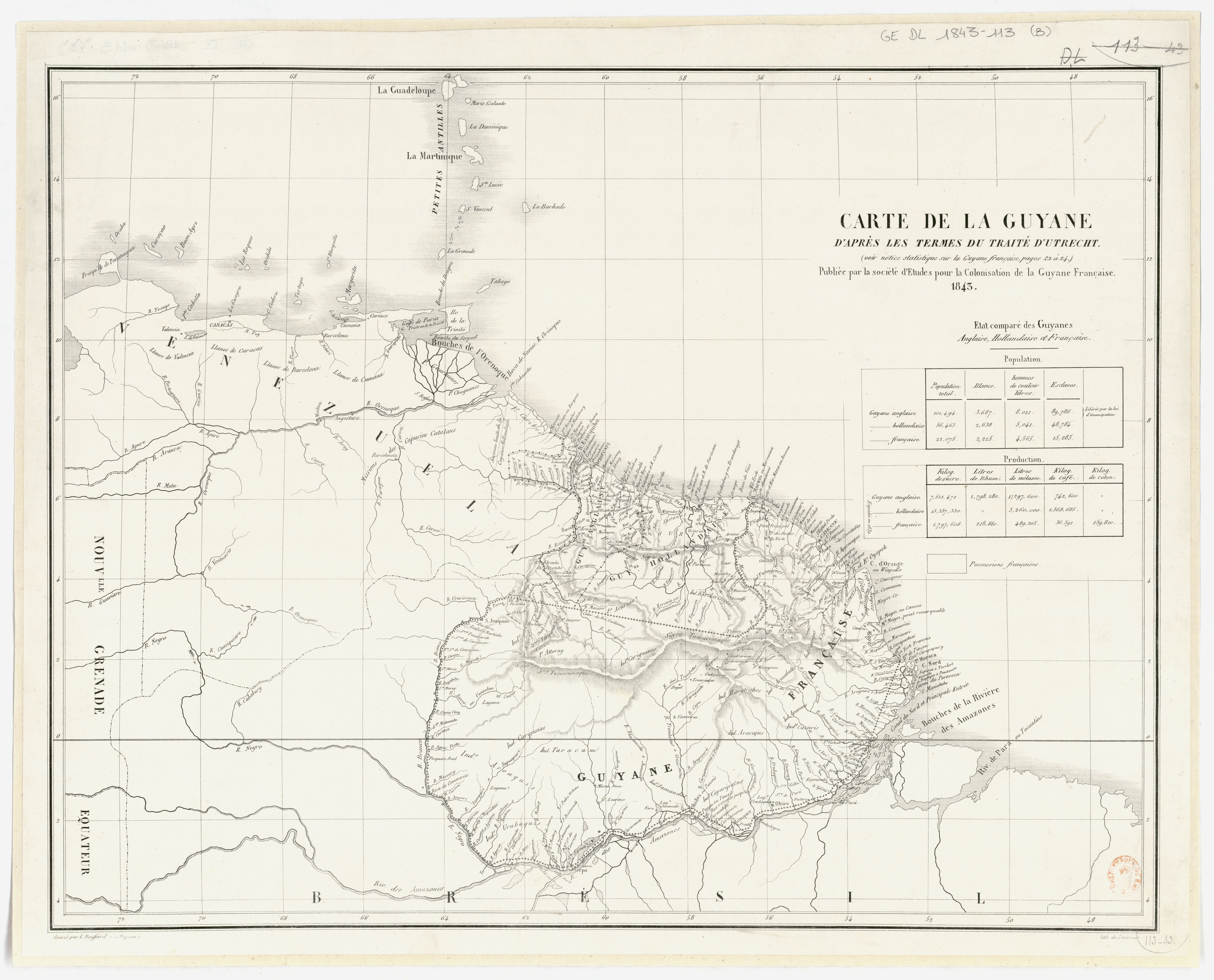
Mapa 1843

Carte de la Guyane d'après les termes du traité d'Utrecht / publiée par la Société d'études pour la colonisation de la Guyane française

  • SOCIÉTÉ D'ÉTUDES POUR LA COLONISATION DE LA GUYANE FRANÇAISE

Publicado: 1843

  • Descargar Imágen
  • Descargar Imágen
Mapa 1843

Carte de la Guyane d'après les termes du traité d'Utrecht / publiée par la Société d'études pour la colonisation de la Guyane française

  • SOCIÉTÉ D'ÉTUDES POUR LA COLONISATION DE LA GUYANE FRANÇAISE

Publicado: 1843

  • Descargar Imágen

Pueblos

  • ACURIAS
  • APAMAS
  • ARACAJUS
  • ARMABUTOS
  • AROAQUIS
  • ARUACA
  • ATTORAY
  • CARIBES
  • CARIGUANOS
  • CARIPUNAS
  • COPARIPUCUS
  • CUZARIS
  • DEGRAS
  • EMERILLONS
  • GALIBIS
  • GUACABAYAS
  • HARYTRAHES
  • JUMUNDAS
  • KIRIKIRISCOTAS
  • MAREMARCHOUA
  • MATABARA
  • OYAMPIS
  • PALENAUES
  • POUPOUROIS
  • RUCUYENES
  • TAOUA
  • TARACUM
  • TUNAYENES
  • TURES
  • URUBAQUIS

Citas

"Carte de la Guyane d'après les termes du traité d'Utrecht / publiée par la Société d'études..." Gallica. Last modified: January 26, 2015. Accessed June 21, 2023. https://gallica.bnf.fr/ark:/12148/btv1b53087501f
  • Descargar Imágen

Artículos Relacionados

Carte du Chili depuis le sud du Perou jusqu'au Cap Horn ...
     par Mr. Bonne, Ingr. Hydrographe de la Marine.

Carte du Chili depuis le sud du Perou jusqu'au Cap Horn ... par Mr. Bonne, Ingr. Hydrographe de la Marine.

Mapa 1780
The modern departments of Ahuachapán, La Libertad, Santa Ana, and Sonsonate (highlighted in red) now contain the highest concentration of Indigenous communities in El Salvador.

The modern departments of Ahuachapán, La Libertad, Santa Ana, and Sonsonate (highlighted in red) now contain the highest concentration of Indigenous communities in El Salvador.

Mapa 2010
Lamento Guaraní

Lamento Guaraní

Obra de Arte
DESCRIPCIÓN GEOGRÁFICA DEL RIO MAMORE O MADERA EN LA AMERICA AUSTRAL DEL DOMINIO DE LA CORONA ESPAÑOLA

DESCRIPCIÓN GEOGRÁFICA DEL RIO MAMORE O MADERA EN LA AMERICA AUSTRAL DEL DOMINIO DE LA CORONA ESPAÑOLA

Mapa 1782
Terra Indígena Tenondé Porã

Terra Indígena Tenondé Porã

Mapa 2012
Departamento de Chiquimula

Departamento de Chiquimula

Mapa 1830 - 1832
CARTE DE LA PROVINCE DE RIO DE JANEIRO

CARTE DE LA PROVINCE DE RIO DE JANEIRO

Mapa 1824
DEMARCACIÓN DE LÍMITES DEL PUEBLO REAL DE INDIOS (REDUCCIÓN) DE TALINA (1573)

DEMARCACIÓN DE LÍMITES DEL PUEBLO REAL DE INDIOS (REDUCCIÓN) DE TALINA (1573)

Mapa 1573

Despojos en las Américas

Un Proyecto de

University of Pennsylvania

Copyright 2024

Con el apoyo de

Mellon Foundation

Diseño y Desarrollo del Sitio

Element 84

Créditos Artísticos

“Carte de la Guyane d’après les termes du traité d’Utrecht / publiée par la Société d’études…” Gallica. Last modified: January 26, 2015. Accessed June 21, 2023. https://gallica.bnf.fr/ark:/12148/btv1b53087501f
Páginas del Sitio

  • Inicio
  • Explorar
  • Autores
  • Sobre
  • Arte
  • Cuerpos
  • Planes de Estudio
  • Herencia Cultural
  • Mapas
  • Territorios