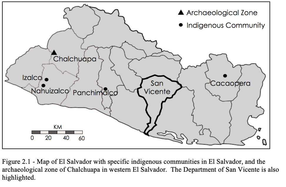
Dispossesions in the Americas

Dispossesions in the Americas

  • Inicio
  • Explorar
  • Autores
  • Sobre
  • Arte
  • Cuerpos
  • Planes de Estudio
  • Herencia Cultural
  • Mapas
  • Territorios
Volver a Explorar

Leyendo en Inglés

Mapa 2010

Map of El Salvador with Specific indigenous communities in El Salvador, and the archaeological zone of Chalchuapa in western El Salvador. The Department of San Vicente is also highlighted.

  • GOMEZ, ESTEBAN MONTES

Publicado: 2010

  • Descargar Imágen
  • Descargar Imágen
Mapa 2010

Map of El Salvador with Specific indigenous communities in El Salvador, and the archaeological zone of Chalchuapa in western El Salvador. The Department of San Vicente is also highlighted.

  • GOMEZ, ESTEBAN MONTES

Publicado: 2010

  • Descargar Imágen

Pueblos

  • IZALCO
  • NAHUIZALCO
  • PANCHIMALCO
  • CACAOPERA

Cita

Goméz, Esteban Montes. "Map of El Salvador with Specific indigenous communities in El Salvador, and the archaeological zone of Chalchuapa in western El Salvador. The Department of San Vicente is also highlighted." IN Archaeology of the Colonial Period Gulf of Fonseca, Eastern El Salvador" PhD Diss. University of California, Berkeley. 2010. pg. 35. https://escholarship.org/content/qt3h6908bz/qt3h6908bz_noSplash_63ed1d6868d6a9d562c348d2708ea5fb.pdf

  • Descargar Imágen

Leyendo en Portugués

Mapa 2010

Map of El Salvador with Specific indigenous communities in El Salvador, and the archaeological zone of Chalchuapa in western El Salvador. The Department of San Vicente is also highlighted.

  • GOMEZ, ESTEBAN MONTES

Publicado: 2010

  • Descargar Imágen

Pueblos

  • IZALCO
  • NAHUIZALCO
  • PANCHIMALCO
  • CACAOPERA

Cita

Goméz, Esteban Montes. "Map of El Salvador with Specific indigenous communities in El Salvador, and the archaeological zone of Chalchuapa in western El Salvador. The Department of San Vicente is also highlighted." IN Archaeology of the Colonial Period Gulf of Fonseca, Eastern El Salvador" PhD Diss. University of California, Berkeley. 2010. pg. 35. https://escholarship.org/content/qt3h6908bz/qt3h6908bz_noSplash_63ed1d6868d6a9d562c348d2708ea5fb.pdf

  • Descargar Imágen

Artículos Relacionados

AYMARA POLITIES of THE QULLASUYU in the 16th CENTURY

AYMARA POLITIES of THE QULLASUYU in the 16th CENTURY

Mapa 1585
Red Bank and Maya Mopan

Red Bank and Maya Mopan

Mapa 1997
Jardín de aclimatación de blancos

Jardín de aclimatación de blancos

Obra de Arte
Grupos étnicos en la época del caucho (1911-1924)

Grupos étnicos en la época del caucho (1911-1924)

Mapa 1911 - 1924
Mapa general del Perú

Mapa general del Perú

Mapa 1865
TERRITORIO DEL SEÑORÍO  AYMARA DE LOS KILLAKAS A PRINCIPIOS DEL SIGLO XVI

TERRITORIO DEL SEÑORÍO AYMARA DE LOS KILLAKAS A PRINCIPIOS DEL SIGLO XVI

Mapa 1500 - 1530
Toba-Maskoy

Toba-Maskoy

Mapa 2001
MAPA de las PROVINCIAS DE VENEZUELA Y DEL REINO DE SANTA FE

MAPA de las PROVINCIAS DE VENEZUELA Y DEL REINO DE SANTA FE

Mapa 1831

Despojos en las Américas

Un Proyecto de

University of Pennsylvania

Copyright 2024

Con el apoyo de

Mellon Foundation

Diseño y Desarrollo del Sitio

Element 84

Créditos Artísticos

Goméz, Esteban Montes. “Map of El Salvador with Specific indigenous communities in El Salvador, and the archaeological zone of Chalchuapa in western El Salvador. The Department of San Vicente is also highlighted.” IN Archaeology of the Colonial Period Gulf of Fonseca, Eastern El Salvador" PhD Diss. University of California, Berkeley. 2010. pg. 35. https://escholarship.org/content/qt3h6908bz/qt3h6908bz_noSplash_63ed1d6868d6a9d562c348d2708ea5fb.pdf

Páginas del Sitio

  • Inicio
  • Explorar
  • Autores
  • Sobre
  • Arte
  • Cuerpos
  • Planes de Estudio
  • Herencia Cultural
  • Mapas
  • Territorios