Dispossesions in the Americas

Dispossesions in the Americas

  • Inicio
  • Explorar
  • Autores
  • Sobre
  • Arte
  • Cuerpos
  • Planes de Estudio
  • Herencia Cultural
  • Mapas
  • Territorios
Volver a Explorar

Leyendo en Inglés

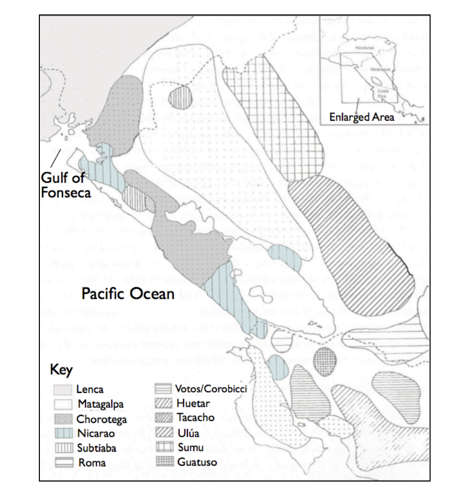
Mapa 1522

Map representing the linguistic diversity that existed in Central America and the Gulf of Fonseca at the time of contact with the Spanish

  • GOMEZ, ESTEBAN MONTES

Publicado: 2010

  • Descargar Imágen
  • Descargar Imágen
Mapa 1522

Map representing the linguistic diversity that existed in Central America and the Gulf of Fonseca at the time of contact with the Spanish

  • GOMEZ, ESTEBAN MONTES

Publicado: 2010

  • Descargar Imágen

Pueblos

  • LENCA
  • MATAGALPA
  • CHOROTEGA
  • NICARAO
  • SUBTIABA
  • ROMA
  • VOTOS
  • COROBICCI
  • HUETAR
  • TACACHO
  • ULUA
  • SUMU
  • GUATUSO

Citas

Goméz, Esteban Montes. "Map representing the linguistic diversity that existed in Central America and the Gulf of Fonseca at the time of contact with the Spanish" IN Archaeology of the Colonial Period Gulf of Fonseca, Eastern El Salvador" PhD Diss. University of California, Berkeley. 2010. pg. 26 https://escholarship.org/content/qt3h6908bz/qt3h6908bz_noSplash_63ed1d6868d6a9d562c348d2708ea5fb.pdf
  • Descargar Imágen

Artículos Relacionados

PUEBLO YAMINAHUA

PUEBLO YAMINAHUA

Mapa 2021
PUEBLO AIMARA

PUEBLO AIMARA

Mapa 2021
EMBOUCHURE DE LA RIVIERE DES AMAZONES

EMBOUCHURE DE LA RIVIERE DES AMAZONES

Mapa 1727
Carte de l'Isle de Caïenne et des rivières voisines dans laquelle on a marqué nommément toutes les habitations qui composent actuellement cette colonie françoise

Carte de l'Isle de Caïenne et des rivières voisines dans laquelle on a marqué nommément toutes les habitations qui composent actuellement cette colonie françoise

Mapa 1729
Guaraní Reta 2008: Pueblos guaraníes en las fronteras de Argentina, Brasil y Paraguay

Guaraní Reta 2008: Pueblos guaraníes en las fronteras de Argentina, Brasil y Paraguay

Mapa 2008
Guyane française. Carte géographo-géologique, dressée d'après les reconnaissances faites de 1867 à 1878 par le bureau du cadastre de Cayenne.

Guyane française. Carte géographo-géologique, dressée d'après les reconnaissances faites de 1867 à 1878 par le bureau du cadastre de Cayenne.

Mapa 1867 - 1878
Geographic Distribution of the Trique

Geographic Distribution of the Trique

Mapa 1969
Guerra con el Indio

Guerra con el Indio

Mapa 1869 - 1894

Despojos en las Américas

Un Proyecto de

University of Pennsylvania

Copyright 2024

Con el apoyo de

Mellon Foundation

Diseño y Desarrollo del Sitio

Element 84

Créditos Artísticos

Goméz, Esteban Montes. “Map representing the linguistic diversity that existed in Central America and the Gulf of Fonseca at the time of contact with the Spanish” IN Archaeology of the Colonial Period Gulf of Fonseca, Eastern El Salvador" PhD Diss. University of California, Berkeley. 2010. pg. 26 https://escholarship.org/content/qt3h6908bz/qt3h6908bz_noSplash_63ed1d6868d6a9d562c348d2708ea5fb.pdf
Páginas del Sitio

  • Inicio
  • Explorar
  • Autores
  • Sobre
  • Arte
  • Cuerpos
  • Planes de Estudio
  • Herencia Cultural
  • Mapas
  • Territorios