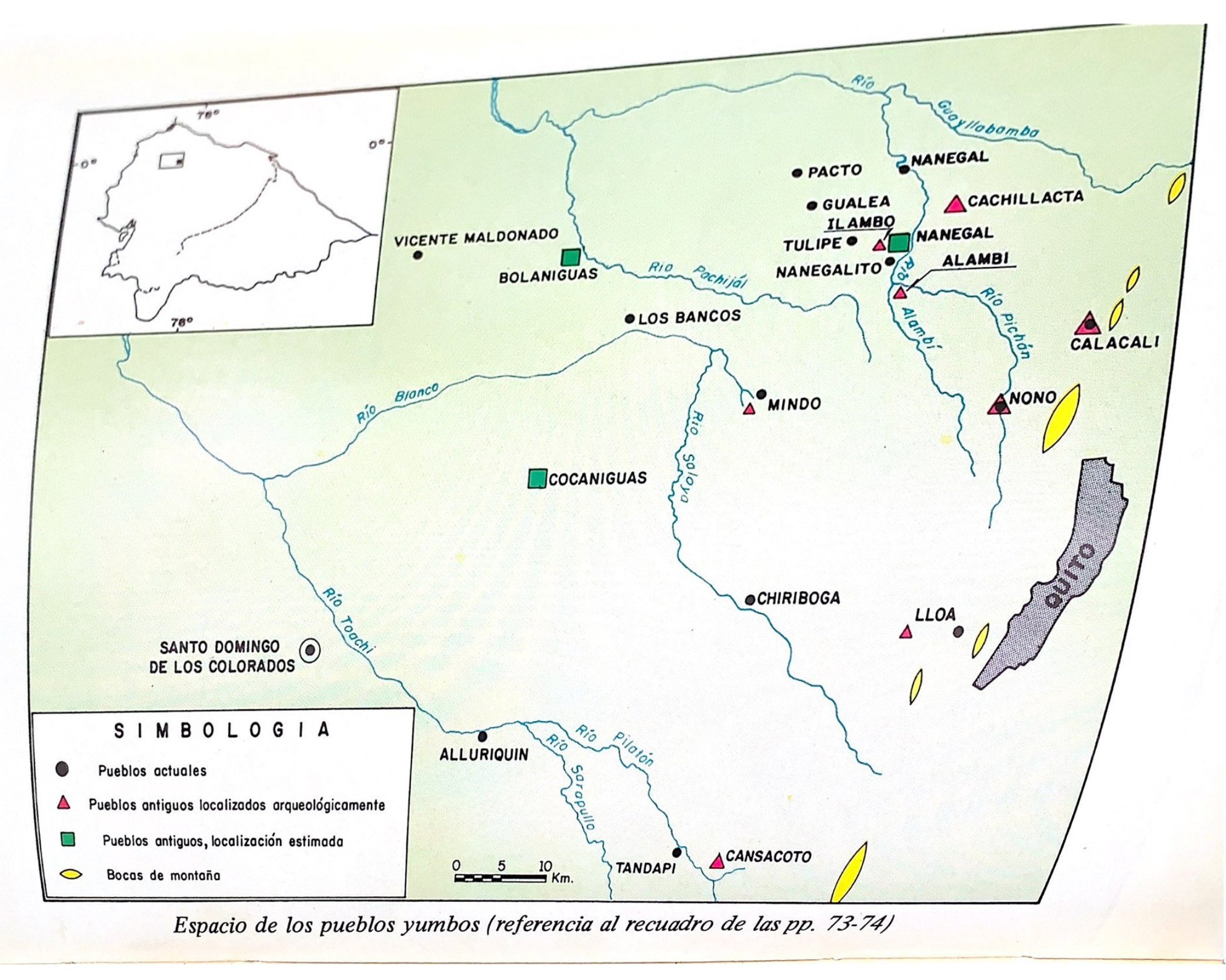
Dispossesions in the Americas

Dispossesions in the Americas

  • Inicio
  • Explorar
  • Autores
  • Sobre
  • Arte
  • Cuerpos
  • Planes de Estudio
  • Herencia Cultural
  • Mapas
  • Territorios
Volver a Explorar

Leyendo en Inglés

Mapa -500 - 1550

Espacio de los pueblos Yumbos (Referencia al recuadro de las pp. 73-74)

  • ENRIQUE AYALA MORA

Publicado: 1983

  • Descargar Imágen
  • Descargar Imágen
Mapa -500 - 1550

Espacio de los pueblos Yumbos (Referencia al recuadro de las pp. 73-74)

  • ENRIQUE AYALA MORA

Publicado: 1983

  • Descargar Imágen

Pueblos

  • YUMBOS

Cita

Ayala Mora;Enrique. Nueva historia del Ecuador. V2. Quito;Ecuador: Corporación Editora Nacional;1983. https://upenn.alma.exlibrisgroup.com/discovery/fulldisplay?vid=01UPENN_INST:Services&id=9918706893503681&inst=01UPENN_INST&context=L

  • Descargar Imágen

Leyendo en Portugués

Mapa -500 - 1550

Espacio de los pueblos Yumbos (Referencia al recuadro de las pp. 73-74)

  • ENRIQUE AYALA MORA

Publicado: 1983

  • Descargar Imágen

Pueblos

  • YUMBOS

Cita

Ayala Mora;Enrique. Nueva historia del Ecuador. V2. Quito;Ecuador: Corporación Editora Nacional;1983. https://upenn.alma.exlibrisgroup.com/discovery/fulldisplay?vid=01UPENN_INST:Services&id=9918706893503681&inst=01UPENN_INST&context=L

  • Descargar Imágen

Artículos Relacionados

CAMINOS DEL KUWAI

CAMINOS DEL KUWAI

Mapa 1399
Peru

Peru

Mapa 1630
Tawahka homeland, 1916: Showing Río Wampú (Wanpo), Río Patuca (Butuk), Cerro Quigungun (Wangkibila Volc [anol]), and the first cartographical rendering of Krautara (Moravian Archives, Bethlehem, Pennsylvania, Heath 1916)

Tawahka homeland, 1916: Showing Río Wampú (Wanpo), Río Patuca (Butuk), Cerro Quigungun (Wangkibila Volc [anol]), and the first cartographical rendering of Krautara (Moravian Archives, Bethlehem, Pennsylvania, Heath 1916)

Mapa 1916
Noa Night

Noa Night

Obra de Arte
Outlines of the physical and political division of South America: Delineated by A. Arrowsmith partly from scarce and original documents, published before the year 1806 but principally from manuscript maps & surveys made between the years 1771 and 1806, corrected from accurate astronomical observations to 1810.

Outlines of the physical and political division of South America: Delineated by A. Arrowsmith partly from scarce and original documents, published before the year 1806 but principally from manuscript maps & surveys made between the years 1771 and 1806, corrected from accurate astronomical observations to 1810.

Mapa 1800 - 1899
Pueblos Indios del Norte Chico y Zona Central de Chile en el Siglo XVI y XVII

Pueblos Indios del Norte Chico y Zona Central de Chile en el Siglo XVI y XVII

Mapa 1500 - 1600
CARTA ETNOGRÁFICA DE MEXICO

CARTA ETNOGRÁFICA DE MEXICO

Mapa 1864
CARTE DU BRÉSIL

CARTE DU BRÉSIL

Mapa 1836

Despojos en las Américas

Un Proyecto de

University of Pennsylvania

Copyright 2024

Con el apoyo de

Mellon Foundation

Diseño y Desarrollo del Sitio

Element 84

Créditos Artísticos

Ayala Mora;Enrique. Nueva historia del Ecuador. V2. Quito;Ecuador: Corporación Editora Nacional;1983. https://upenn.alma.exlibrisgroup.com/discovery/fulldisplay?vid=01UPENN_INST:Services&id=9918706893503681&inst=01UPENN_INST&context=L

Páginas del Sitio

  • Inicio
  • Explorar
  • Autores
  • Sobre
  • Arte
  • Cuerpos
  • Planes de Estudio
  • Herencia Cultural
  • Mapas
  • Territorios