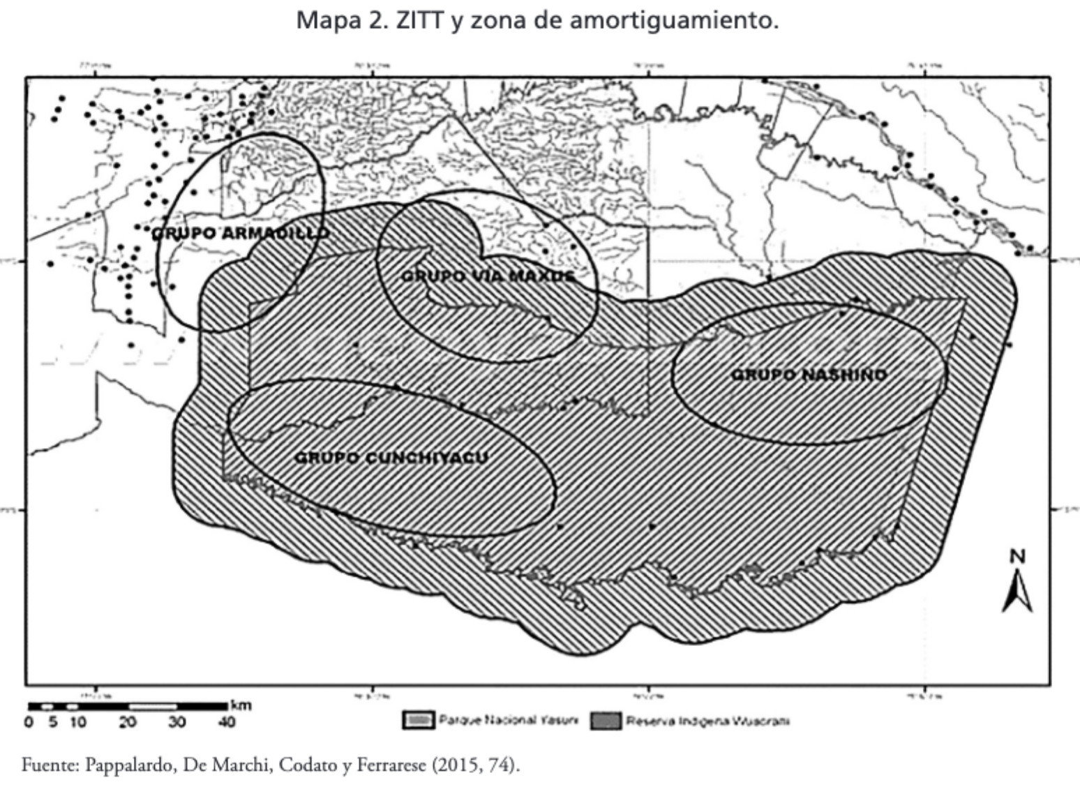
Dispossesions in the Americas

Dispossesions in the Americas

  • Inicio
  • Explorar
  • Autores
  • Sobre
  • Arte
  • Cuerpos
  • Planes de Estudio
  • Herencia Cultural
  • Mapas
  • Territorios
Volver a Explorar

Leyendo en Inglés

Mapa 2015

MAPA 2. ZITT Y ZONA DE AMORTIGUAMIENTO.

  • PAPPALARDO;DE MARCHI;CODATO Y FERRARESE

Publicado: 2017

  • Descargar Imágen
  • Descargar Imágen
Mapa 2015

MAPA 2. ZITT Y ZONA DE AMORTIGUAMIENTO.

  • PAPPALARDO;DE MARCHI;CODATO Y FERRARESE

Publicado: 2017

  • Descargar Imágen

Pueblos

  • WAORANI
  • TAGAERI
  • TAROMENANE

Citas

Narváez Quiñónez;Iván Tarcicio. “Amazonía: Cambio de La Comprensión de La Territorialidad Al Interior Del Territorio Waorani (Los Derechos Indígenas)/ Amazon: Change of the Understanding of the Territoriality to the Interior of the Waorani Territory (indigenous Rights).” Eutopía.;no. 12 (2017). https://revistas.flacsoandes.edu.ec/eutopia/article/view/2906/2052

  • Descargar Imágen

Artículos Relacionados

Departamentos y municipios de mayor concentración del pueblo Cofán

Departamentos y municipios de mayor concentración del pueblo Cofán

Mapa 2005
LA PROVINCIA DE POTOSÍ EN EL ALTO PERÚ EN EL SIGLO XVII

LA PROVINCIA DE POTOSÍ EN EL ALTO PERÚ EN EL SIGLO XVII

Mapa 1600 - 1699
Desde adentro. Las comunidades originarias de la Argentina

Desde adentro. Las comunidades originarias de la Argentina

Mapa 1600
Carte 6: Migrations des Tupi au nord de l'Amazones (XVIe et XVIIe siècles)

Carte 6: Migrations des Tupi au nord de l'Amazones (XVIe et XVIIe siècles)

Mapa 1500 - 1699
Map of Nicaragua showing Ulwa settlements in Eastern Nicaragua and field study sites (in rectangle)

Map of Nicaragua showing Ulwa settlements in Eastern Nicaragua and field study sites (in rectangle)

Mapa 1990
BRASILIA

BRASILIA

Mapa 1600 - 1699
"Transversalidad Histórica entre las Tierras Indidas de 1940 y los Pueblos Indígenas de Costa Rica en la actualidad"

"Transversalidad Histórica entre las Tierras Indidas de 1940 y los Pueblos Indígenas de Costa Rica en la actualidad"

Mapa 1940 - 2014
YBYTOSO ISHIR

YBYTOSO ISHIR

Mapa 2015

Despojos en las Américas

Un Proyecto de

University of Pennsylvania

Copyright 2024

Con el apoyo de

Mellon Foundation

Diseño y Desarrollo del Sitio

Element 84

Créditos Artísticos

Narváez Quiñónez;Iván Tarcicio. “Amazonía: Cambio de La Comprensión de La Territorialidad Al Interior Del Territorio Waorani (Los Derechos Indígenas)/ Amazon: Change of the Understanding of the Territoriality to the Interior of the Waorani Territory (indigenous Rights).” Eutopía.;no. 12 (2017). https://revistas.flacsoandes.edu.ec/eutopia/article/view/2906/2052

Páginas del Sitio

  • Inicio
  • Explorar
  • Autores
  • Sobre
  • Arte
  • Cuerpos
  • Planes de Estudio
  • Herencia Cultural
  • Mapas
  • Territorios