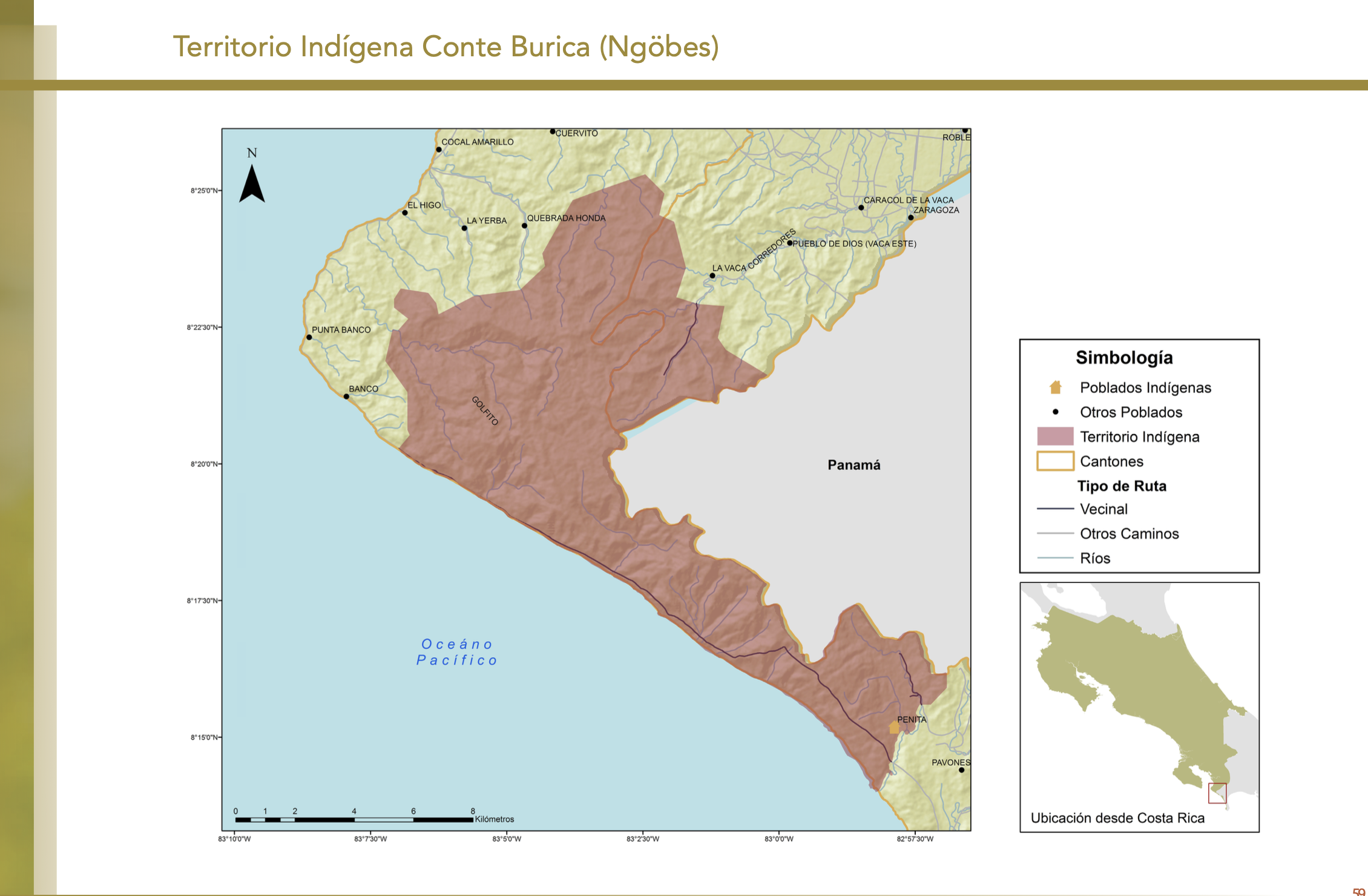
Dispossesions in the Americas

Dispossesions in the Americas

  • Inicio
  • Explorar
  • Autores
  • Sobre
  • Arte
  • Cuerpos
  • Planes de Estudio
  • Herencia Cultural
  • Mapas
  • Territorios
Volver a Explorar

Leyendo en Inglés

Mapa 2013

MAPA 1. TERRITORIO WAORANI;GRUPOS TAGAERI;TAROMENANE Y BLOQUES PETROLEROS EN EL YASUNÍ

  • EUGENIO PAPPALARDO

Publicado: 2017

  • Descargar Imágen
  • Descargar Imágen
Mapa 2013

MAPA 1. TERRITORIO WAORANI;GRUPOS TAGAERI;TAROMENANE Y BLOQUES PETROLEROS EN EL YASUNÍ

  • EUGENIO PAPPALARDO

Publicado: 2017

  • Descargar Imágen

Pueblos

  • WAORANI
  • TAGAERI
  • TAROMENANE

Cita

Narváez Quiñónez;Iván Tarcicio. “Amazonía: Cambio de La Comprensión de La Territorialidad Al Interior Del Territorio Waorani (Los Derechos Indígenas)/ Amazon: Change of the Understanding of the Territoriality to the Interior of the Waorani Territory (indigenous Rights).” Eutopía.;no. 12 (2017). https://revistas.flacsoandes.edu.ec/eutopia/article/view/2906/2052

  • Descargar Imágen

Leyendo en Portugués

Mapa 2013

MAPA 1. TERRITORIO WAORANI;GRUPOS TAGAERI;TAROMENANE Y BLOQUES PETROLEROS EN EL YASUNÍ

  • EUGENIO PAPPALARDO

Publicado: 2017

  • Descargar Imágen

Pueblos

  • WAORANI
  • TAGAERI
  • TAROMENANE

Cita

Narváez Quiñónez;Iván Tarcicio. “Amazonía: Cambio de La Comprensión de La Territorialidad Al Interior Del Territorio Waorani (Los Derechos Indígenas)/ Amazon: Change of the Understanding of the Territoriality to the Interior of the Waorani Territory (indigenous Rights).” Eutopía.;no. 12 (2017). https://revistas.flacsoandes.edu.ec/eutopia/article/view/2906/2052

  • Descargar Imágen

Artículos Relacionados

Blue Creek

Blue Creek

Mapa 1997
Croquis III. (b) La región andina septentrional ecuatoriana (Moreno Yanez;1989;2)

Croquis III. (b) La región andina septentrional ecuatoriana (Moreno Yanez;1989;2)

Mapa -500 - 1530
RESGUARDOS Y TERRITORIOS INDIGENAS EN COLOMBIA

RESGUARDOS Y TERRITORIOS INDIGENAS EN COLOMBIA

Mapa 2015
The Pech: Most important municipios, 2001

The Pech: Most important municipios, 2001

Mapa 2001
PUEBLOS QUECHUAS

PUEBLOS QUECHUAS

Mapa 2021
Asiento del pueblo de Santiago Atitlán c 1585.

Asiento del pueblo de Santiago Atitlán c 1585.

Mapa 1585
MAPA 1 LÍMITES GEOGRAFICOS DE LA LÍNEA NEGRA

MAPA 1 LÍMITES GEOGRAFICOS DE LA LÍNEA NEGRA

Mapa 2018
O Parque Municipal [El Parque Municipal]

O Parque Municipal [El Parque Municipal]

Obra de Arte

Despojos en las Américas

Un Proyecto de

University of Pennsylvania

Copyright 2024

Con el apoyo de

Mellon Foundation

Diseño y Desarrollo del Sitio

Element 84

Créditos Artísticos

Narváez Quiñónez;Iván Tarcicio. “Amazonía: Cambio de La Comprensión de La Territorialidad Al Interior Del Territorio Waorani (Los Derechos Indígenas)/ Amazon: Change of the Understanding of the Territoriality to the Interior of the Waorani Territory (indigenous Rights).” Eutopía.;no. 12 (2017). https://revistas.flacsoandes.edu.ec/eutopia/article/view/2906/2052

Páginas del Sitio

  • Inicio
  • Explorar
  • Autores
  • Sobre
  • Arte
  • Cuerpos
  • Planes de Estudio
  • Herencia Cultural
  • Mapas
  • Territorios