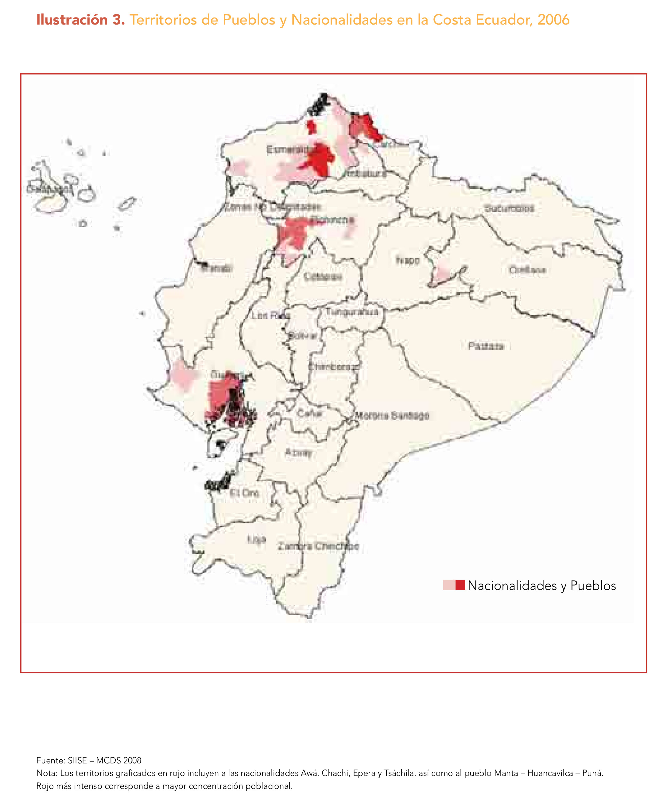
Dispossesions in the Americas

Dispossesions in the Americas

  • Inicio
  • Explorar
  • Autores
  • Sobre
  • Arte
  • Cuerpos
  • Planes de Estudio
  • Herencia Cultural
  • Mapas
  • Territorios
Volver a Explorar

Leyendo en Inglés

Mapa 1628

PARTE DEL MAR DEL SUR DESDE C. DE S. FRANCISCO HASTA PAIJTA EN LA COSTA DE PERÚ

  • GERARD VAN KEULEN

Publicado: 1721

  • Descargar Imágen
  • Descargar Imágen
Mapa 1628

PARTE DEL MAR DEL SUR DESDE C. DE S. FRANCISCO HASTA PAIJTA EN LA COSTA DE PERÚ

  • GERARD VAN KEULEN

Publicado: 1721

  • Descargar Imágen

Pueblos

  • CARANQUI
  • PURUWA
  • CAYAMBE
  • PALTAS
  • HUANCAVILCAS
  • JIPIJAPA

Cita

Keulen;Gerard van. “Leiden University Libraries Digital Collections.” Een gedeelte van de Zuijd-Zee van C. de S. Francisco tot Paijta aen de kust van Peru COLLBN 003-09-006 | Digital Collections;1721. https://digitalcollections.universiteitleiden.nl/view/item/130408.

  • Descargar Imágen

Leyendo en Portugués

Mapa 1628

PARTE DEL MAR DEL SUR DESDE C. DE S. FRANCISCO HASTA PAIJTA EN LA COSTA DE PERÚ

  • GERARD VAN KEULEN

Publicado: 1721

  • Descargar Imágen

Pueblos

  • CARANQUI
  • PURUWA
  • CAYAMBE
  • PALTAS
  • HUANCAVILCAS
  • JIPIJAPA

Cita

Keulen;Gerard van. “Leiden University Libraries Digital Collections.” Een gedeelte van de Zuijd-Zee van C. de S. Francisco tot Paijta aen de kust van Peru COLLBN 003-09-006 | Digital Collections;1721. https://digitalcollections.universiteitleiden.nl/view/item/130408.

  • Descargar Imágen

Artículos Relacionados

MAPA 2. UBICACIÓN DE LOS ACTUALES PUEBLOS HUAORANI

MAPA 2. UBICACIÓN DE LOS ACTUALES PUEBLOS HUAORANI

Mapa 1981
BRASILIA qua parte paret BELGIS

BRASILIA qua parte paret BELGIS

Mapa 1644
PLAN de la Ville de l’Assomption, dans LE PARAGUAY

PLAN de la Ville de l’Assomption, dans LE PARAGUAY

Mapa 1781
Mapa de la Republica de Guatemala

Mapa de la Republica de Guatemala

Mapa 1800
Ilustración 3. Territorios de Pueblos y Nacionalidades en la Costa Ecuador;2006

Ilustración 3. Territorios de Pueblos y Nacionalidades en la Costa Ecuador;2006

Mapa 2006
TERRITORIOS ANCESTRALES DE LOS CUATRO PUEBLOS INDIGENAS DE LA SSNM (MAPA APROXIMATIVO DE REFERENCIA)

TERRITORIOS ANCESTRALES DE LOS CUATRO PUEBLOS INDIGENAS DE LA SSNM (MAPA APROXIMATIVO DE REFERENCIA)

Mapa 2009
[Ecuador & Peru Coastlines] Carta particolare del'Peru che comincia con il capo di Guanapo e finisce con il C. S:

[Ecuador & Peru Coastlines] Carta particolare del'Peru che comincia con il capo di Guanapo e finisce con il C. S:

Mapa 1646
Map representing the linguistic diversity that existed in Central America and the Gulf of Fonseca at the time of contact with the Spanish

Map representing the linguistic diversity that existed in Central America and the Gulf of Fonseca at the time of contact with the Spanish

Mapa 1522

Despojos en las Américas

Un Proyecto de

University of Pennsylvania

Copyright 2024

Con el apoyo de

Mellon Foundation

Diseño y Desarrollo del Sitio

Element 84

Créditos Artísticos

Keulen;Gerard van. “Leiden University Libraries Digital Collections.” Een gedeelte van de Zuijd-Zee van C. de S. Francisco tot Paijta aen de kust van Peru COLLBN 003-09-006 | Digital Collections;1721. https://digitalcollections.universiteitleiden.nl/view/item/130408.

Páginas del Sitio

  • Inicio
  • Explorar
  • Autores
  • Sobre
  • Arte
  • Cuerpos
  • Planes de Estudio
  • Herencia Cultural
  • Mapas
  • Territorios