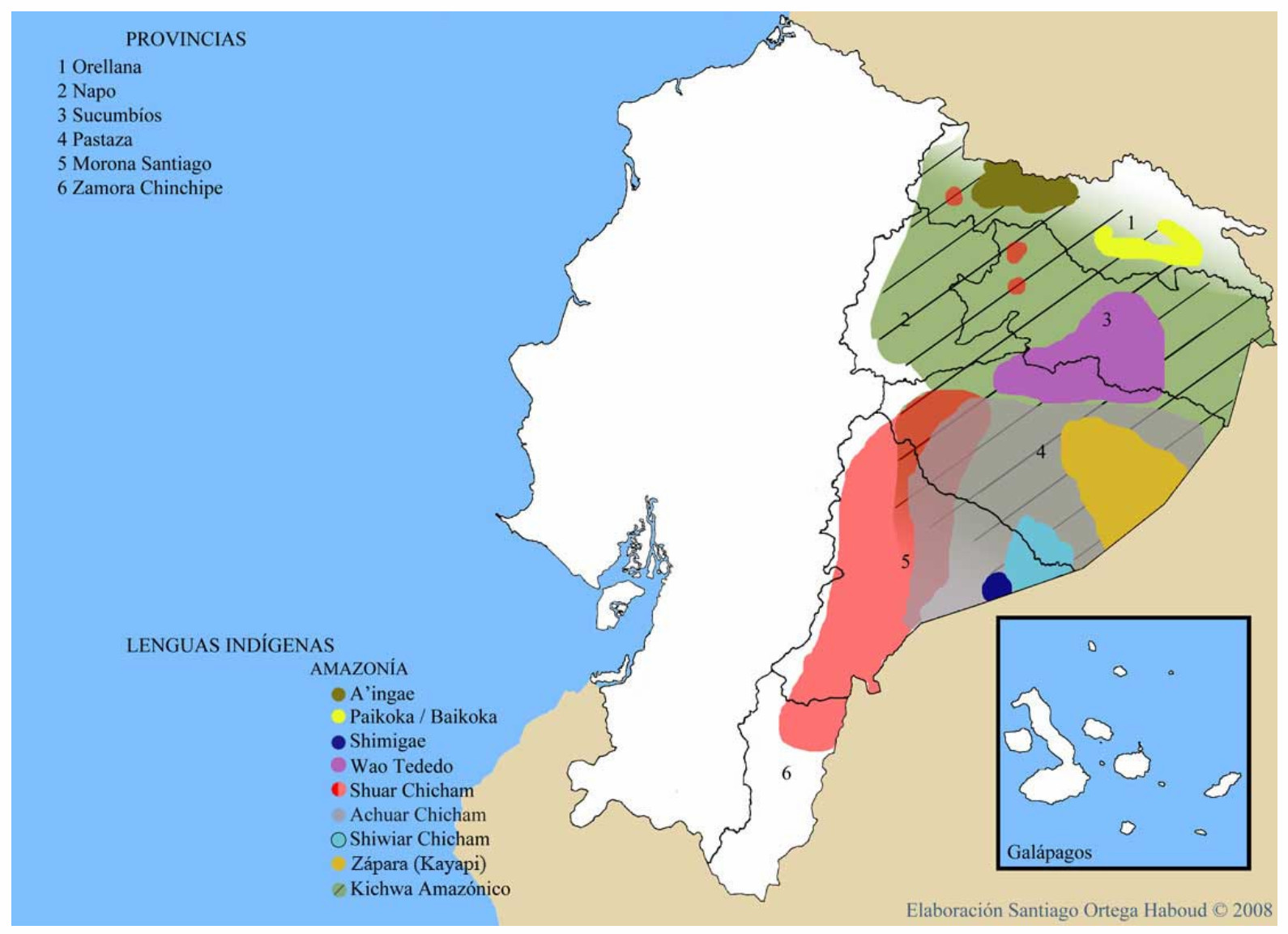
Dispossesions in the Americas

Dispossesions in the Americas

  • Inicio
  • Explorar
  • Autores
  • Sobre
  • Arte
  • Cuerpos
  • Planes de Estudio
  • Herencia Cultural
  • Mapas
  • Territorios
Volver a Explorar

Leyendo en Inglés

Mapa 2008

LENGUAS INDIGENAS AMAZONIA

  • SANTIAGO ORTEGA HABOUD

Publicado: 2008

  • Descargar Imágen
  • Descargar Imágen
Mapa 2008

LENGUAS INDIGENAS AMAZONIA

  • SANTIAGO ORTEGA HABOUD

Publicado: 2008

  • Descargar Imágen

Pueblos

  • AI'COFAN
  • SIONA
  • SECOYA
  • ANDOA
  • HUAORANI
  • SHUAR
  • ACHUAR
  • SHIWIAR
  • ZAPARA
  • KICHWA

Citas

Ortega Haboud;Santiago. "Nacionalidades Indígenas de la Amazonia." Map. Oralidad Modernidad. 2008. Accessed August 4;2021. https://www.puce.edu.ec/oralidadmodernidad/amazonia.php.

  • Descargar Imágen

Artículos Relacionados

L'Isola Cuba è piu Settetrioal'della Spagnolei et è acor essa molto abodate di zuccaro, cottone, oro et altre cose simili

L'Isola Cuba è piu Settetrioal'della Spagnolei et è acor essa molto abodate di zuccaro, cottone, oro et altre cose simili

Mapa 1500 - 1599
Terra Indígena Piaçaguera

Terra Indígena Piaçaguera

Mapa 2011
IDIOMAS DE GUATEMALA

IDIOMAS DE GUATEMALA

Mapa 1988
A Sequel of the Seat of War in the West Indies containing… Sub-map title: A large & accurate MAP of part of the Isthmus of Panama, taken from a Spanish drought exhibiting the Country adjacent to that City and Puerto Bello, with the Roads and Course of the River CHAGRE, by which the Treasure of the South Sea is conveyed a cross the Isthmus

A Sequel of the Seat of War in the West Indies containing… Sub-map title: A large & accurate MAP of part of the Isthmus of Panama, taken from a Spanish drought exhibiting the Country adjacent to that City and Puerto Bello, with the Roads and Course of the River CHAGRE, by which the Treasure of the South Sea is conveyed a cross the Isthmus

Mapa 1740
Vereinigte Provinzen am LA PLATA Oberperu und Paraguay

Vereinigte Provinzen am LA PLATA Oberperu und Paraguay

Mapa 1826
Fases de la rebelión indígena de 1781 en el corregimiento de Atacama y esquema de la inestabilidad política que la precede 1749-1781

Fases de la rebelión indígena de 1781 en el corregimiento de Atacama y esquema de la inestabilidad política que la precede 1749-1781

Mapa 1500
Mapa de las tierras indígenas - Situación legal

Mapa de las tierras indígenas - Situación legal

Mapa 2017
Carte de la Guyane Francoise ou France Equinoxiale. Grand, beau et très fertile Pays de l'Amerique Meridionale, située entre la Riviere de Marauny et le Cap Nord

Carte de la Guyane Francoise ou France Equinoxiale. Grand, beau et très fertile Pays de l'Amerique Meridionale, située entre la Riviere de Marauny et le Cap Nord

Mapa 1763

Despojos en las Américas

Un Proyecto de

University of Pennsylvania

Copyright 2024

Con el apoyo de

Mellon Foundation

Diseño y Desarrollo del Sitio

Element 84

Créditos Artísticos

Ortega Haboud;Santiago. “Nacionalidades Indígenas de la Amazonia.” Map. Oralidad Modernidad. 2008. Accessed August 4;2021. https://www.puce.edu.ec/oralidadmodernidad/amazonia.php.

Páginas del Sitio

  • Inicio
  • Explorar
  • Autores
  • Sobre
  • Arte
  • Cuerpos
  • Planes de Estudio
  • Herencia Cultural
  • Mapas
  • Territorios