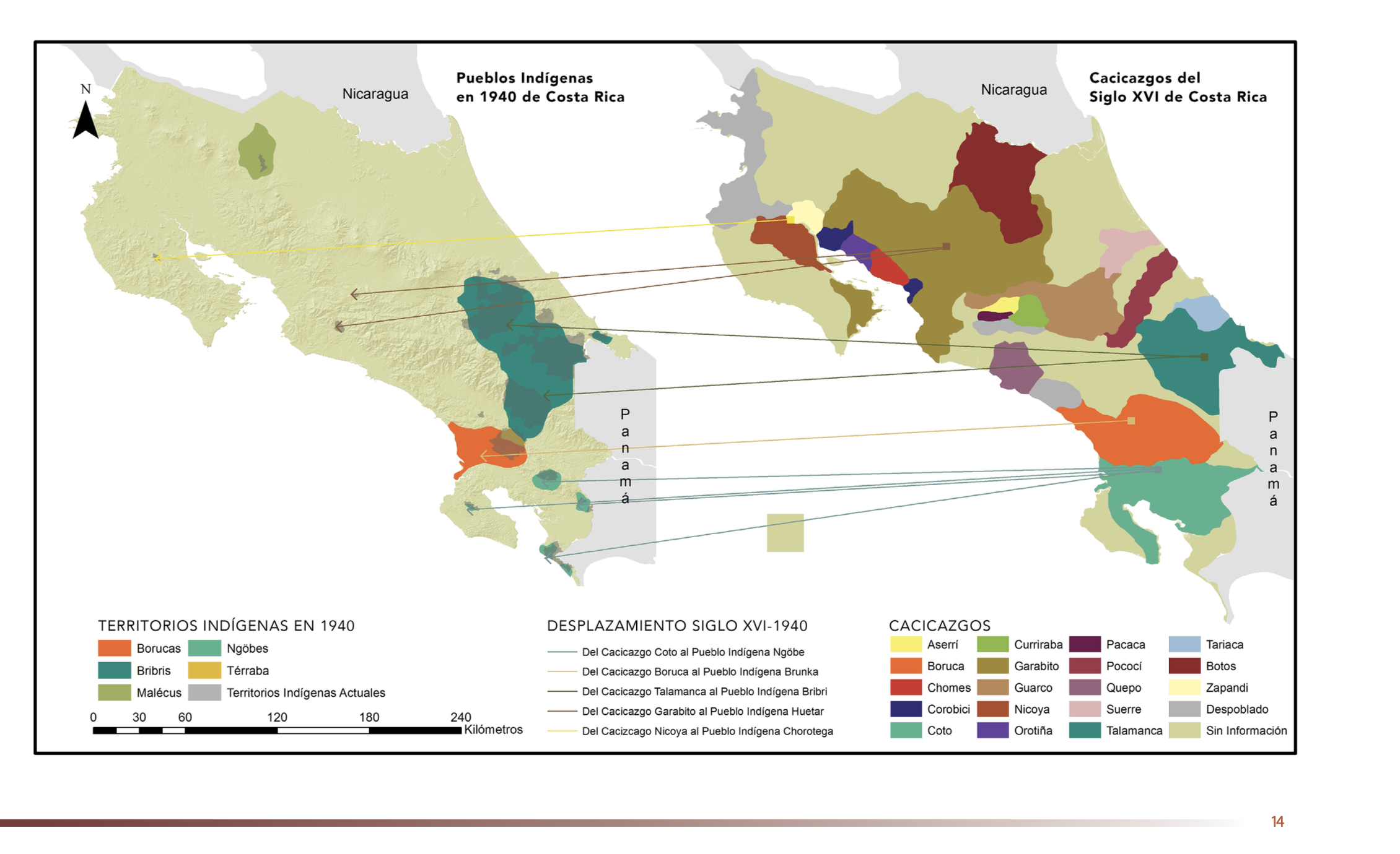
Dispossesions in the Americas

Dispossesions in the Americas

  • Inicio
  • Explorar
  • Autores
  • Sobre
  • Arte
  • Cuerpos
  • Planes de Estudio
  • Herencia Cultural
  • Mapas
  • Territorios
Volver a Explorar

Leyendo en Inglés

Mapa 1500 - 1899

"Pueblos Indígenas 1940 y Cacicazgos del Siglo XVI de Costa Rica"

  • GÓMEZ ET AL.

Publicado: 2014

  • Descargar Imágen
  • Descargar Imágen
Mapa 1500 - 1899

"Pueblos Indígenas 1940 y Cacicazgos del Siglo XVI de Costa Rica"

  • GÓMEZ ET AL.

Publicado: 2014

  • Descargar Imágen

Pueblos

  • BORUCAS
  • BRIBRIS
  • MALECUS
  • NGOBES
  • TERRABA
  • ASERRI
  • BORUCA
  • CHOMES
  • COROBICI
  • COTO
  • CUIRRABA
  • GARABITO
  • GUARCO
  • NICOYA
  • OROTINA
  • PACACA
  • POCOCI
  • QUEPO
  • SUERRE
  • TALAMANCA
  • TARIACA
  • BOTOS
  • ZAPANDI

Citas

Gómez Meléndez, Agustín, Felipe González Evora, Heiddys García, Marco      Espinoza, and Fabián Solano Monge. Atlas de territorios      indígenas--Universidad de Costa Rica. Costa Rica: Universidad de Costa      Rica, 2014.         https://hdl.handle.net/10669/15088

  • Descargar Imágen

Artículos Relacionados

Map of the RIVER JURUÁ

Map of the RIVER JURUÁ

Mapa 1869
MAPA LOCAL DE TOCHPAN

MAPA LOCAL DE TOCHPAN

Mapa 1400 - 1499
PUEBLO YANESHA

PUEBLO YANESHA

Mapa 2021
Carte d'une partie de la Riviere de Marony qui separe la Guïanne Françoise des Hollandois Levée depuis son embouchure, Jusqu'au premier Sault.

Carte d'une partie de la Riviere de Marony qui separe la Guïanne Françoise des Hollandois Levée depuis son embouchure, Jusqu'au premier Sault.

Mapa 1700 - 1799
Pueblos indígenas en la Amazonía del Ecuador

Pueblos indígenas en la Amazonía del Ecuador

Mapa 2021
Mapa de Zonas de Influencia Cultural

Mapa de Zonas de Influencia Cultural

Mapa 1720 - 1821
Distribución étnica en el siglo XVI

Distribución étnica en el siglo XVI

Mapa 1500 - 1599
A Sequel of the Seat of War in the West Indies containing… Sub-map title: A large & accurate MAP of part of the Isthmus of Panama, taken from a Spanish drought exhibiting the Country adjacent to that City and Puerto Bello, with the Roads and Course of the River CHAGRE, by which the Treasure of the South Sea is conveyed a cross the Isthmus

A Sequel of the Seat of War in the West Indies containing… Sub-map title: A large & accurate MAP of part of the Isthmus of Panama, taken from a Spanish drought exhibiting the Country adjacent to that City and Puerto Bello, with the Roads and Course of the River CHAGRE, by which the Treasure of the South Sea is conveyed a cross the Isthmus

Mapa 1740

Despojos en las Américas

Un Proyecto de

University of Pennsylvania

Copyright 2024

Con el apoyo de

Mellon Foundation

Diseño y Desarrollo del Sitio

Element 84

Créditos Artísticos

Gómez Meléndez, Agustín, Felipe González Evora, Heiddys García, Marco      Espinoza, and Fabián Solano Monge. Atlas de territorios      indígenas–Universidad de Costa Rica. Costa Rica: Universidad de Costa      Rica, 2014.         https://hdl.handle.net/10669/15088

Páginas del Sitio

  • Inicio
  • Explorar
  • Autores
  • Sobre
  • Arte
  • Cuerpos
  • Planes de Estudio
  • Herencia Cultural
  • Mapas
  • Territorios