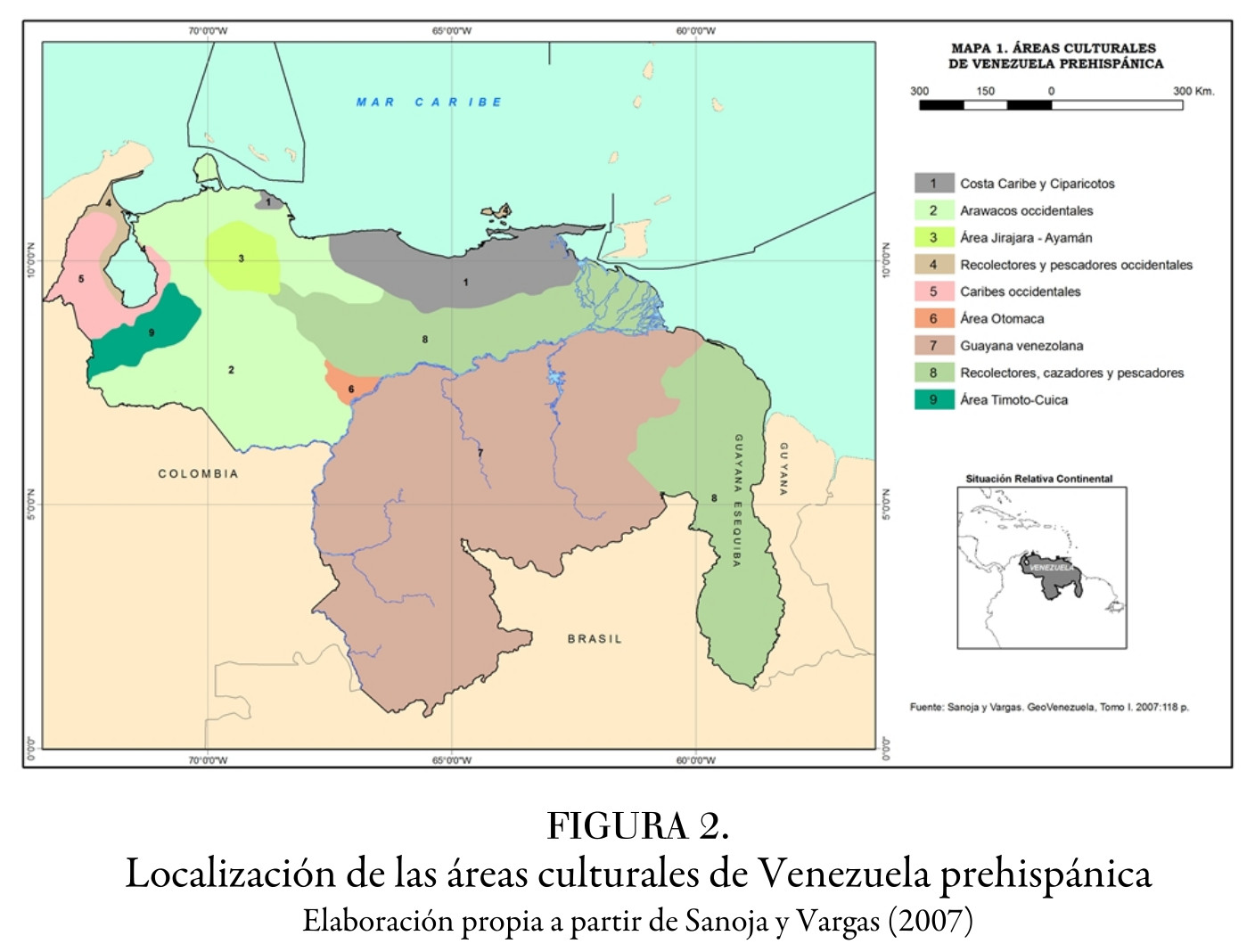
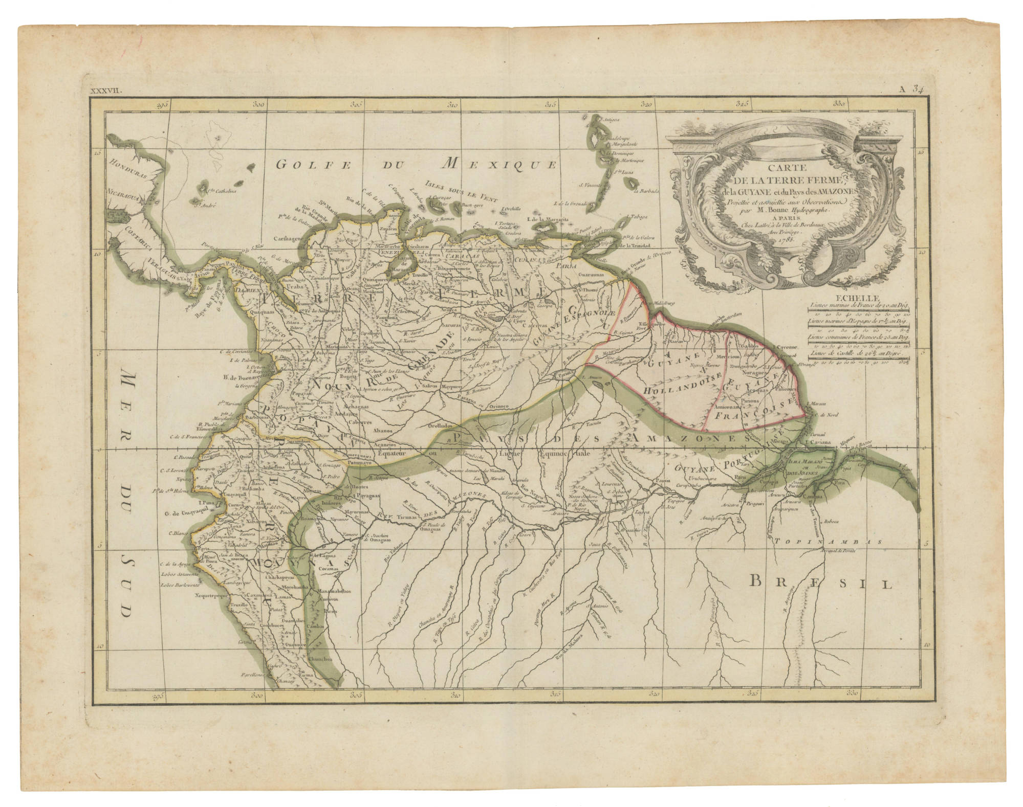
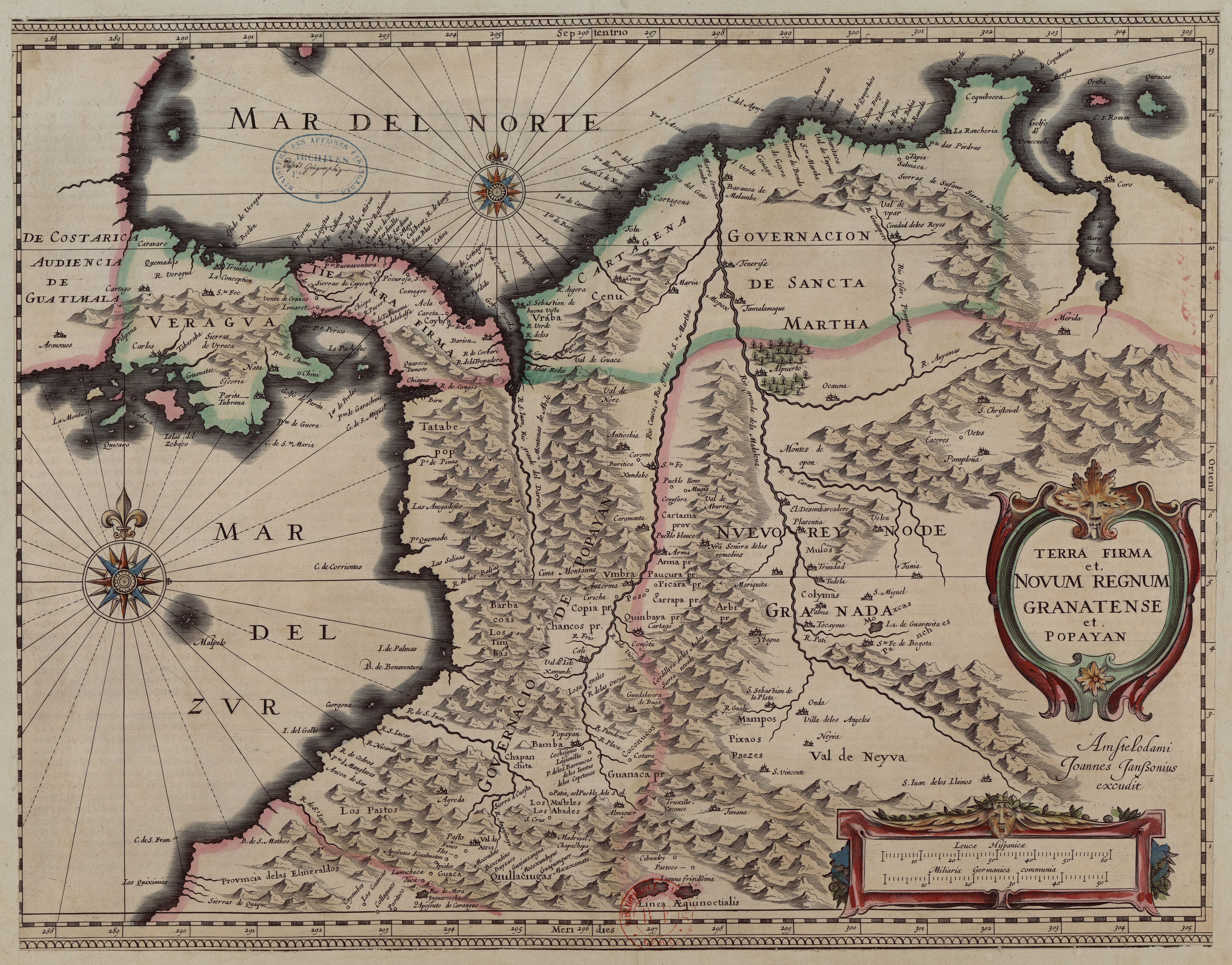
Dispossesions in the Americas

Dispossesions in the Americas

  • Inicio
  • Explorar
  • Autores
  • Sobre
  • Arte
  • Cuerpos
  • Planes de Estudio
  • Herencia Cultural
  • Mapas
  • Territorios
Volver a Explorar

Leyendo en Inglés

Mapa 1635

Terra Firma et Novum Regnum Granatense et Popayan

  • Joannes Janssonius

Publicado: 1635

  • Descargar Imágen
  • Descargar Imágen
Mapa 1635

Terra Firma et Novum Regnum Granatense et Popayan

  • Joannes Janssonius

Publicado: 1635

  • Descargar Imágen

Pueblos

  • ABADES
  • BAMBA
  • BARBACOAS
  • COCONUCOS
  • COLIMAS
  • MAMPOS
  • MASTELES
  • MUISCAS
  • MUSOS
  • PASTOS
  • PAEZ
  • PANCHES
  • PIJAO
  • QUILLACINGAS
  • QUIMBAYA
  • TATABE
  • TIMBAS URABA
  • ZENU

Citas

Janssonius, Joannes. "Terra Firma et Novum Regnum Granatense et Popayan", 1635. Banco de la República. https://babel.banrepcultural.org/digital/collection/p17054coll13/id/424.AccessedApril11,2022.(Númerotopográfico:H278)

  • Descargar Imágen

Artículos Relacionados

PUEBLO OTOMI

PUEBLO OTOMI

Mapa 2020
San Vicente

San Vicente

Mapa 1997
MAP 7.—The Highland tribes of Colombia and Ecuador. (Drawn from data compiled by Gregorio Hernández de Alba;John Murra;Sergio Elías Ortíz;and Henri Lehmann.)

MAP 7.—The Highland tribes of Colombia and Ecuador. (Drawn from data compiled by Gregorio Hernández de Alba;John Murra;Sergio Elías Ortíz;and Henri Lehmann.)

Mapa 1400
PRESENT-DAY MAYA LANGUAGE BOUNDARIES OF GUATEMALA

PRESENT-DAY MAYA LANGUAGE BOUNDARIES OF GUATEMALA

Mapa 1961
Map of Culhuacan (Valley of Mexico), 1580, Relacion geografica de Culhuacan

Map of Culhuacan (Valley of Mexico), 1580, Relacion geografica de Culhuacan

Mapa 1580
PARAGUAY UND DER NÖRDLICHE THEIL DER ARGENTINISCHEN REPUBLIK

PARAGUAY UND DER NÖRDLICHE THEIL DER ARGENTINISCHEN REPUBLIK

Mapa 1853 - 56
PUEBLOS DE INDIOS DE LAS INTENDENCIAS Y GOBIERNOS MILITARES DE LA NUEVA ESPAÑA EN 1800 (4,468 PUEBLOS DE INDIOS)

PUEBLOS DE INDIOS DE LAS INTENDENCIAS Y GOBIERNOS MILITARES DE LA NUEVA ESPAÑA EN 1800 (4,468 PUEBLOS DE INDIOS)

Mapa 1800
An exact draught of the Gulf of Darien & the coast to Porto Bello with Panama in the South sea & the Scotch settlement in Calledonia

An exact draught of the Gulf of Darien & the coast to Porto Bello with Panama in the South sea & the Scotch settlement in Calledonia

Mapa 1700 - 1799

Despojos en las Américas

Un Proyecto de

University of Pennsylvania

Copyright 2024

Con el apoyo de

Mellon Foundation

Diseño y Desarrollo del Sitio

Element 84

Créditos Artísticos

Janssonius, Joannes. “Terra Firma et Novum Regnum Granatense et Popayan”, 1635. Banco de la República. https://babel.banrepcultural.org/digital/collection/p17054coll13/id/424.AccessedApril11,2022.(Númerotopográfico:H278)

Páginas del Sitio

  • Inicio
  • Explorar
  • Autores
  • Sobre
  • Arte
  • Cuerpos
  • Planes de Estudio
  • Herencia Cultural
  • Mapas
  • Territorios