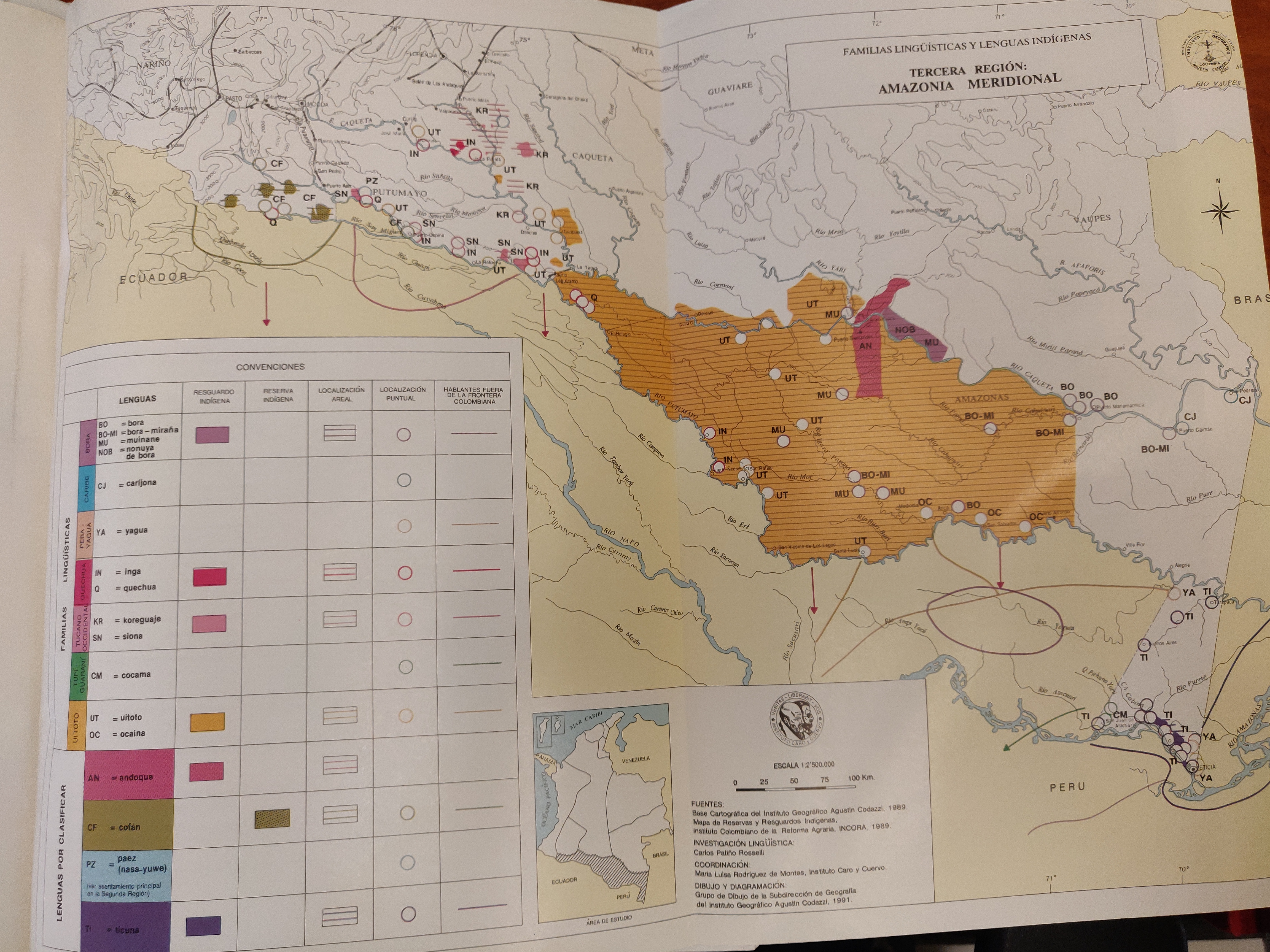
Dispossesions in the Americas

Dispossesions in the Americas

  • Inicio
  • Explorar
  • Autores
  • Sobre
  • Arte
  • Cuerpos
  • Planes de Estudio
  • Herencia Cultural
  • Mapas
  • Territorios
Volver a Explorar

Leyendo en Inglés

Mapa 1989

FAMILIAS LINGUISTICAS Y LENGUAS INDIGENAS - TERCERA REGION: AMAZONIA MERIDIONAL

  • INCORA-INSTITUTO GEOGRAFICO AGUSTIN CODAZZI

Publicado: 1989

  • Descargar Imágen
  • Descargar Imágen
Mapa 1989

FAMILIAS LINGUISTICAS Y LENGUAS INDIGENAS - TERCERA REGION: AMAZONIA MERIDIONAL

  • INCORA-INSTITUTO GEOGRAFICO AGUSTIN CODAZZI

Publicado: 1989

  • Descargar Imágen

Pueblos

  • BORA
  • BORA-MIRANA
  • MUINANE
  • CARIJONA
  • NONUYA DE BORA
  • CARIBE
  • CARIJONA
  • PEBA YAGUA
  • YAGUA
  • INGA
  • QUECHUA
  • TUCANO
  • KOREGUAJE
  • SIONA
  • TUPI-GUARANI
  • COCAMA
  • UIOTOTO
  • OCAINA

Cita

Stella Gonzalez de Perez y Maria Luisa Rodriguez de Montes (2000), "Lenguas Indigenas de Colombia," Instituto Caro y Cuervo, Bogota. 1989 (Familias linguísticas y lenguas indígenas - Tercera región. Amazonía meridional, p. 168)

  • Descargar Imágen

Leyendo en Portugués

Mapa 1989

FAMILIAS LINGUISTICAS Y LENGUAS INDIGENAS - TERCERA REGION: AMAZONIA MERIDIONAL

  • INCORA-INSTITUTO GEOGRAFICO AGUSTIN CODAZZI

Publicado: 1989

  • Descargar Imágen

Pueblos

  • BORA
  • BORA-MIRANA
  • MUINANE
  • CARIJONA
  • NONUYA DE BORA
  • CARIBE
  • CARIJONA
  • PEBA YAGUA
  • YAGUA
  • INGA
  • QUECHUA
  • TUCANO
  • KOREGUAJE
  • SIONA
  • TUPI-GUARANI
  • COCAMA
  • UIOTOTO
  • OCAINA

Cita

Stella Gonzalez de Perez y Maria Luisa Rodriguez de Montes (2000), "Lenguas Indigenas de Colombia," Instituto Caro y Cuervo, Bogota. 1989 (Familias linguísticas y lenguas indígenas - Tercera región. Amazonía meridional, p. 168)

  • Descargar Imágen

Artículos Relacionados

MAPA DE LA REPÚBLICA DEL PARAGUAY

MAPA DE LA REPÚBLICA DEL PARAGUAY

Mapa
Stone Butch

Stone Butch

Obra de Arte
"Territorio Indígena Quitirrisí (Huétar)"

"Territorio Indígena Quitirrisí (Huétar)"

Mapa 2010
XXIV. Carte du Rio Grande de la Magdalena, depuis ses sources jusqu'a son embouchure.

XXIV. Carte du Rio Grande de la Magdalena, depuis ses sources jusqu'a son embouchure.

Mapa 1799 - 1804
Explorations de la Guyane par Henri Coudreau, 1887-89, 1889-91.

Explorations de la Guyane par Henri Coudreau, 1887-89, 1889-91.

Mapa 1887 - 1891
Mapa de localización del Territorio de la Nación Pueblo Ocloya-Provincia de Jujuy-Argentina

Mapa de localización del Territorio de la Nación Pueblo Ocloya-Provincia de Jujuy-Argentina

Mapa 2016
Railroad Map of British Honduras Transportation Department of the United States Department of Commerce. Library of Congress Geography and Map Division. https://hdl.loc.gov/loc.wdl/wdl.11329

Railroad Map of British Honduras Transportation Department of the United States Department of Commerce. Library of Congress Geography and Map Division. https://hdl.loc.gov/loc.wdl/wdl.11329

Mapa 1900
Do Rio Turi ate a entrada do Grao Para

Do Rio Turi ate a entrada do Grao Para

Mapa 1600 - 1640

Despojos en las Américas

Un Proyecto de

University of Pennsylvania

Copyright 2024

Con el apoyo de

Mellon Foundation

Diseño y Desarrollo del Sitio

Element 84

Créditos Artísticos

Stella Gonzalez de Perez y Maria Luisa Rodriguez de Montes (2000), “Lenguas Indigenas de Colombia,” Instituto Caro y Cuervo, Bogota. 1989 (Familias linguísticas y lenguas indígenas - Tercera región. Amazonía meridional, p. 168)

Páginas del Sitio

  • Inicio
  • Explorar
  • Autores
  • Sobre
  • Arte
  • Cuerpos
  • Planes de Estudio
  • Herencia Cultural
  • Mapas
  • Territorios