Dispossesions in the Americas

Dispossesions in the Americas

  • Inicio
  • Explorar
  • Autores
  • Sobre
  • Arte
  • Cuerpos
  • Planes de Estudio
  • Herencia Cultural
  • Mapas
  • Territorios
Volver a Explorar

Leyendo en Inglés

Mapa 2000 - 2024

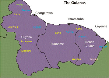
Fig. 1 Map of the Guianas with schematic locations of the indigenous groups relevant to our study, based on the linguistic map of South America (http://www.muturzikin.com/cartesamerique/ 7.htm). Carib-speaking groups are indicated in yellow, Arawak-speaking groups in blue, Tupi-speaking Wayãpi in pink and the Warao-speaking group in green

  • Andel, Tinde van;Ruysschaert, Sofie;Boven, Karin;Daly, Lewis

Publicado: 2015

  • Descargar Imágen
  • Descargar Imágen
Mapa 2000 - 2024

Fig. 1 Map of the Guianas with schematic locations of the indigenous groups relevant to our study, based on the linguistic map of South America (http://www.muturzikin.com/cartesamerique/ 7.htm). Carib-speaking groups are indicated in yellow, Arawak-speaking groups in blue, Tupi-speaking Wayãpi in pink and the Warao-speaking group in green

  • Andel, Tinde van;Ruysschaert, Sofie;Boven, Karin;Daly, Lewis

Publicado: 2015

  • Descargar Imágen

Pueblos

  • AKAWAIO
  • ARAWAK
  • CARIB
  • MAKUSHI
  • PALIKUR
  • PATAMONA
  • WARAO
  • WAYANA
  • WAYAPI

Citas

Andel, Tinde van, Ruysschaert, Sofie, Boven, Karin, Daly, Lewis. The use of Amerindian charm plants in the Guianas. Journal of Ethnobiology and Ethnomedicine. Accessed, August 29, 2023. https://ethnobiomed.biomedcentral.com/articles/10.1186/s13002-015-0048-9
  • Descargar Imágen

Artículos Relacionados

Paî Tavyterâ

Paî Tavyterâ

Mapa 2001
DEMARCACIÓN DE LÍMITES DEL PUEBLO REAL DE INDIOS (REDUCCIÓN) DE TALINA (1573)

DEMARCACIÓN DE LÍMITES DEL PUEBLO REAL DE INDIOS (REDUCCIÓN) DE TALINA (1573)

Mapa 1573
Carte de la Guyane Françoise et l'Isle de Cayenne. Dressée au Dépost des Cartes et Plans de la Marine Par Ordre de M. le Duc de Choiseul Ministre de la Guerre et de la Marine.

Carte de la Guyane Françoise et l'Isle de Cayenne. Dressée au Dépost des Cartes et Plans de la Marine Par Ordre de M. le Duc de Choiseul Ministre de la Guerre et de la Marine.

Mapa 1763
Aché

Aché

Mapa 2001
Descripción de las Provincias del Chaco, y confinantes segun las relaciones modernas, y noticias adquiridas por diversas entradas de los Misioneros de la Compañía de Jesús que se han hecho en este siglo de 1700.

Descripción de las Provincias del Chaco, y confinantes segun las relaciones modernas, y noticias adquiridas por diversas entradas de los Misioneros de la Compañía de Jesús que se han hecho en este siglo de 1700.

Mapa 1800 - 1899
Croquis IV. La región litoral ecuatoriana (Moreno Yanez;1989;2)

Croquis IV. La región litoral ecuatoriana (Moreno Yanez;1989;2)

Mapa -500 - 1530
Familias lingüísticas en Andes Centro y Sur

Familias lingüísticas en Andes Centro y Sur

Mapa 2000 - 2024
THE QULLASUYU IN THE 1530s – SOUTHERN DISTRICT OF THE INCA STATE

THE QULLASUYU IN THE 1530s – SOUTHERN DISTRICT OF THE INCA STATE

Mapa 1530

Despojos en las Américas

Un Proyecto de

University of Pennsylvania

Copyright 2024

Con el apoyo de

Mellon Foundation

Diseño y Desarrollo del Sitio

Element 84

Créditos Artísticos

Andel, Tinde van, Ruysschaert, Sofie, Boven, Karin, Daly, Lewis. The use of Amerindian charm plants in the Guianas. Journal of Ethnobiology and Ethnomedicine. Accessed, August 29, 2023. https://ethnobiomed.biomedcentral.com/articles/10.1186/s13002-015-0048-9
Páginas del Sitio

  • Inicio
  • Explorar
  • Autores
  • Sobre
  • Arte
  • Cuerpos
  • Planes de Estudio
  • Herencia Cultural
  • Mapas
  • Territorios