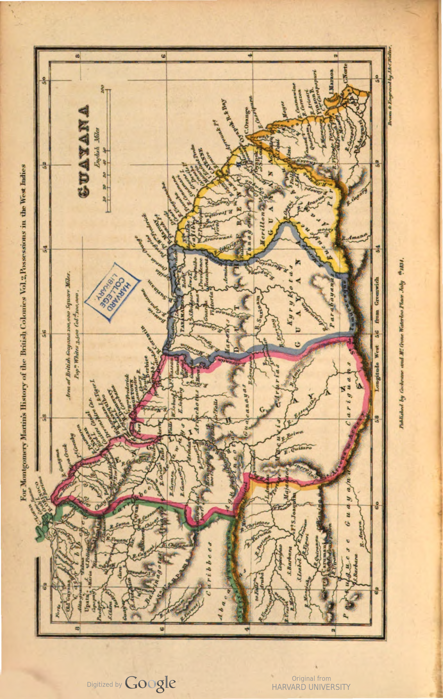
Dispossesions in the Americas

Dispossesions in the Americas

  • Inicio
  • Explorar
  • Autores
  • Sobre
  • Arte
  • Cuerpos
  • Planes de Estudio
  • Herencia Cultural
  • Mapas
  • Territorios
Volver a Explorar

Leyendo en Inglés

Mapa 1800 - 1899

Guyana

  • Martin, Montgomery

Publicado: 1834

  • Descargar Imágen
  • Descargar Imágen
Mapa 1800 - 1899

Guyana

  • Martin, Montgomery

Publicado: 1834

  • Descargar Imágen

Pueblos

  • ABACARUAS
  • ACCAWAYS
  • AGUARINCOTAS
  • ARAMICHSUU
  • ARINCHOTAS
  • ARUACAS
  • ARURIAS
  • BARINAGOTAS
  • CARIBBEES
  • CARIGUANS
  • CARRIBBEE
  • GALIBIS
  • GUACANAYAS
  • KYRYKOTAS
  • MACUSIS
  • MAJANAOS
  • MARONES
  • MERILLON
  • PARABAYANAS
  • PIRIUS
  • RUCUYENES
  • TUNAYENES

Citas

Martin, Montgomery, History of the British colonies. By R. Montgomery Martin. v.2. HathiTrust, Last modified: December 29, 2022. Accessed, August 14, 2023. https://hdl.handle.net/2027/hvd.32044009927740?urlappend=%3Bseq=38%3Bownerid=27021597764948586-42

  • Descargar Imágen

Artículos Relacionados

Partie de la Colombie et du Bresil. Amer. Merid. no. 9. (Dresse par Ph. Vandermaelen;lithographie par H. Ode. Cinquieme partie - Amer. merid. Bruxelles. 1827)

Partie de la Colombie et du Bresil. Amer. Merid. no. 9. (Dresse par Ph. Vandermaelen;lithographie par H. Ode. Cinquieme partie - Amer. merid. Bruxelles. 1827)

Mapa 1827
PLANO de los rios “NAPO” y “PUTUMAYO” levantado por orden del Señor Prefecto del Departamento Coronel D. PEDRO PORTILLO

PLANO de los rios “NAPO” y “PUTUMAYO” levantado por orden del Señor Prefecto del Departamento Coronel D. PEDRO PORTILLO

Mapa 1903
CONCENTRACIÓN DE POBLACION DE TRES Y MAS ANOS QUE HABLAN LENGUA INDÍGENA EN MÉRIDA, YUCATÁN, 2010

CONCENTRACIÓN DE POBLACION DE TRES Y MAS ANOS QUE HABLAN LENGUA INDÍGENA EN MÉRIDA, YUCATÁN, 2010

Mapa 2012
Carte de l'embouchure d'Ouyapoc

Carte de l'embouchure d'Ouyapoc

Mapa 1700 - 1799
Mappa da actual distribuição dos indios no Brazil meridional

Mappa da actual distribuição dos indios no Brazil meridional

Mapa 1857 - 1907
Karte von BRITISCH ~ GUYANA;nebst dem Quelllande des Prima (Rio Branco) und Orinoco

Karte von BRITISCH ~ GUYANA;nebst dem Quelllande des Prima (Rio Branco) und Orinoco

Mapa 1835 - 1844
Localización Territorial de los Collas Hacia Fines del Siglo XIX y Principios de Siglo XX."

Localización Territorial de los Collas Hacia Fines del Siglo XIX y Principios de Siglo XX."

Mapa 1800 - 1900
DISTRIBUCIÓN DE LOS GRUPOS INDÍGENAS EN EL SIGLO XVI

DISTRIBUCIÓN DE LOS GRUPOS INDÍGENAS EN EL SIGLO XVI

Mapa 1500 - 1599

Despojos en las Américas

Un Proyecto de

University of Pennsylvania

Copyright 2024

Con el apoyo de

Mellon Foundation

Diseño y Desarrollo del Sitio

Element 84

Créditos Artísticos

Martin, Montgomery, History of the British colonies. By R. Montgomery Martin. v.2. HathiTrust, Last modified: December 29, 2022. Accessed, August 14, 2023. https://hdl.handle.net/2027/hvd.32044009927740?urlappend=%3Bseq=38%3Bownerid=27021597764948586-42

Páginas del Sitio

  • Inicio
  • Explorar
  • Autores
  • Sobre
  • Arte
  • Cuerpos
  • Planes de Estudio
  • Herencia Cultural
  • Mapas
  • Territorios