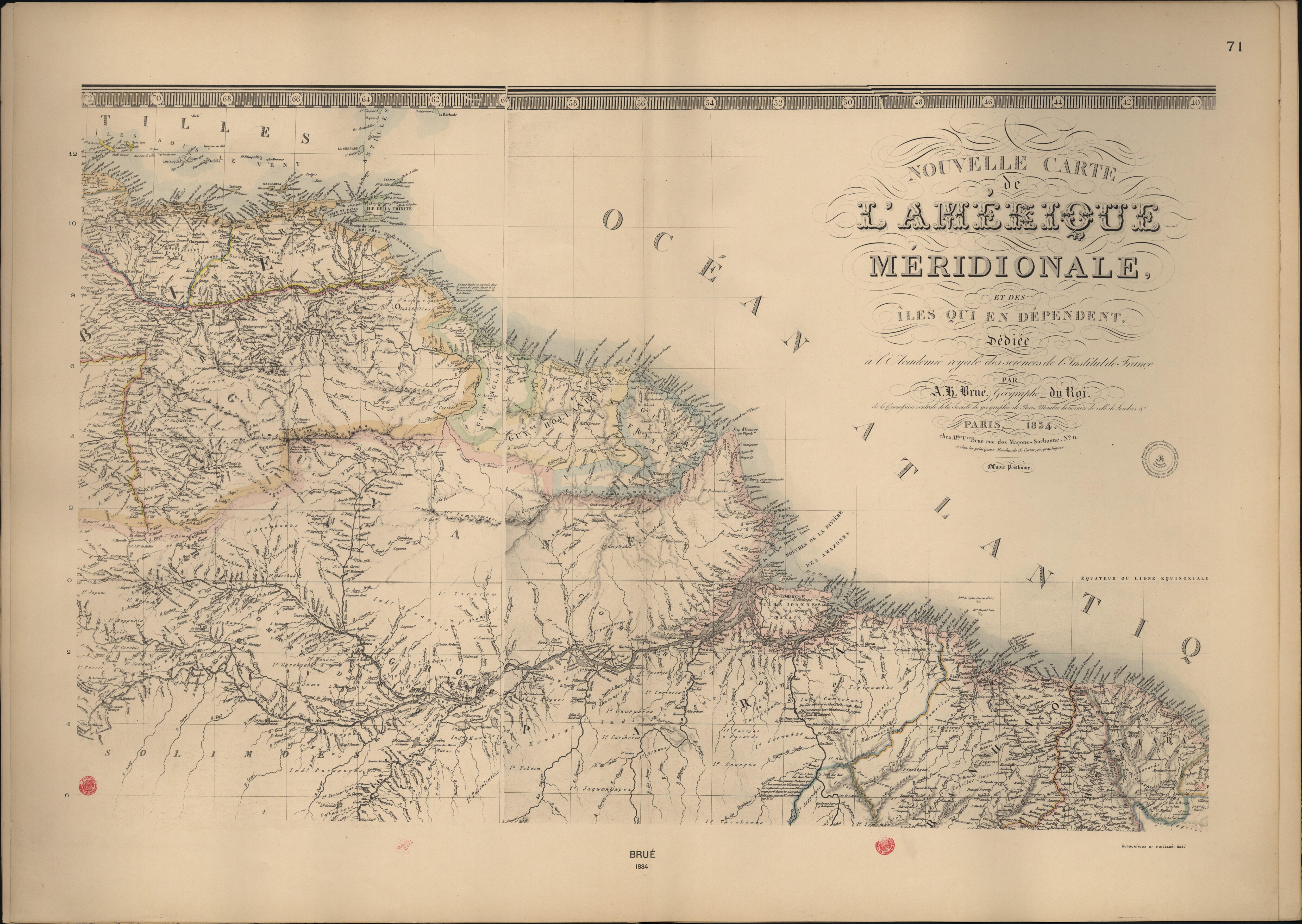
Dispossesions in the Americas

Dispossesions in the Americas

  • Inicio
  • Explorar
  • Autores
  • Sobre
  • Arte
  • Cuerpos
  • Planes de Estudio
  • Herencia Cultural
  • Mapas
  • Territorios
Volver a Explorar

Leyendo en Inglés

Mapa 1800 - 1899

Nouvelle Carte de l'Amérique Méridionale, et des îles qui en dépendent dédiée à l'Academie royale des sciences de l'Institut de France.

  • Brué, A. H.

Publicado: 1834

  • Descargar Imágen
  • Descargar Imágen
Mapa 1800 - 1899

Nouvelle Carte de l'Amérique Méridionale, et des îles qui en dépendent dédiée à l'Academie royale des sciences de l'Institut de France.

  • Brué, A. H.

Publicado: 1834

  • Descargar Imágen

Pueblos

  • ABARA
  • ACURIAS
  • ANNAPUS
  • APPYNAGES
  • ARINACOTOS
  • ARINOS
  • ARMABUTOS
  • ARMACOTOS
  • AMICOUANOS
  • AROAQUIS
  • ARUACAS
  • ARURAS
  • BUS
  • CABRES
  • CAMECRANS
  • CANELLAS-FINAS
  • CANAQUETGEZ
  • CAPINHAROS
  • CARAHYABY
  • CARIBERIS
  • CARIBES
  • CARIGUANOS
  • CATAUIXIS
  • CHAGUARAMAS
  • CHERUPICHAHENA
  • CHUGUANES
  • COPARIPUCUS
  • CORETUS
  • CURENAOS
  • CURIARES
  • CUZARYS
  • DEMACURY
  • EMERILLONS
  • ENGAYABAS
  • GALIBIS
  • GAMELLAS
  • GES
  • GUACABAYAS
  • GUAJAJARES
  • GUAJOJARAS
  • GUAQUIRIS
  • GUARAUNOS
  • GUARUARAS
  • GUAYCAS
  • GUJANCOMOS
  • HARYTRAHES
  • HYABAHANAS
  • IGARUANAS
  • ITATAPRIYAS
  • JACUNDAS
  • JADITANOS
  • JAQUANHAPEZ
  • JUMUNDAS
  • JAPUAS
  • JAVIPUJAS
  • JUMA
  • JUMANAS
  • JURIS
  • JURUNAS
  • KIRIKIRISCOTOS
  • LOAUANNA
  • MACAMECRANS
  • MACOS
  • MACUS
  • MAGUES
  • MAUHES
  • MANAOS
  • MANOAS
  • MAPOJOS
  • MAPURES
  • MARARITARES
  • MARUCOTOS
  • MATAUACA
  • MATEIROS
  • MEJEPURES
  • MEPPURIS
  • MIRANHAS
  • MORONONIS
  • MUNDRUCUS
  • MURAS
  • OMAGUAS
  • OREMUNAOS
  • OYAMPIS
  • PACAJAS
  • PACARAS
  • PALENAUES
  • PANDACOCOS
  • PARECA
  • PARENTINTINS
  • PASSES
  • PIACOBGES
  • PIRAOAS
  • PUIPUITENES
  • PURUPURUS
  • QUIRIQUIRIPOS
  • RUCUYENES
  • SACAMECRANS
  • SACAN
  • SALIVA
  • SAQUEME KRABES
  • TABAJARIS
  • TABBAXARAS
  • TACAHUNAS
  • TACUCUNAS
  • TACUHUNAS
  • TACUNHAPEZ
  • TARACUM
  • TARAMAMBAY
  • TEMEMBOS
  • TIMBIRAS DA MATTA
  • TOPINAMBAS
  • TRAMEMBEZ
  • TUERES
  • TUNAYENES
  • TUPINAMBAS
  • UARIHUA
  • UAUPES
  • URUBAQUIS
  • XOMANAS
  • YABAIM
  • YARUROS

Citas

Brué, A. H., Atlas accompagnant le premier mémoire du Brésil. Biblioteca Nacional Digital.1834. Accessed, August 14, 2023. bndigital.bnportugal.gov.pt/idviewer/14413/112 bndigital.bnportugal.gov.pt/idviewer/14413/112

  • Descargar Imágen

Artículos Relacionados

Provincia do AMAZONAS

Provincia do AMAZONAS

Mapa 1800 - 1850
Departamentos y municipios de mayor concentración del pueblo Cofán

Departamentos y municipios de mayor concentración del pueblo Cofán

Mapa 2005
PINTURA DE CULHUACÁN

PINTURA DE CULHUACÁN

Mapa 1500 - 1599
Mosquitia or The Mosquito Shore with The Eastern Part of Yucatán as far as the 20th Degree of North Latitude

Mosquitia or The Mosquito Shore with The Eastern Part of Yucatán as far as the 20th Degree of North Latitude

Mapa 1787
Isles de Cayenne

Isles de Cayenne

Mapa 1686
The Southern Maya Lowlands during the Sixteenth and Seventeenth Centuries

The Southern Maya Lowlands during the Sixteenth and Seventeenth Centuries

Mapa 1500 - 1700
A PROVINCIA do PARANÁ. CARTA CHOROGRAFICA

A PROVINCIA do PARANÁ. CARTA CHOROGRAFICA

Mapa 1866
Guide map of the tribes and subjects of Volume 1 of the Handbook

Guide map of the tribes and subjects of Volume 1 of the Handbook

Mapa

Despojos en las Américas

Un Proyecto de

University of Pennsylvania

Copyright 2024

Con el apoyo de

Mellon Foundation

Diseño y Desarrollo del Sitio

Element 84

Créditos Artísticos

Brué, A. H., Atlas accompagnant le premier mémoire du Brésil. Biblioteca Nacional Digital.1834. Accessed, August 14, 2023. bndigital.bnportugal.gov.pt/idviewer/14413/112 bndigital.bnportugal.gov.pt/idviewer/14413/112

Páginas del Sitio

  • Inicio
  • Explorar
  • Autores
  • Sobre
  • Arte
  • Cuerpos
  • Planes de Estudio
  • Herencia Cultural
  • Mapas
  • Territorios