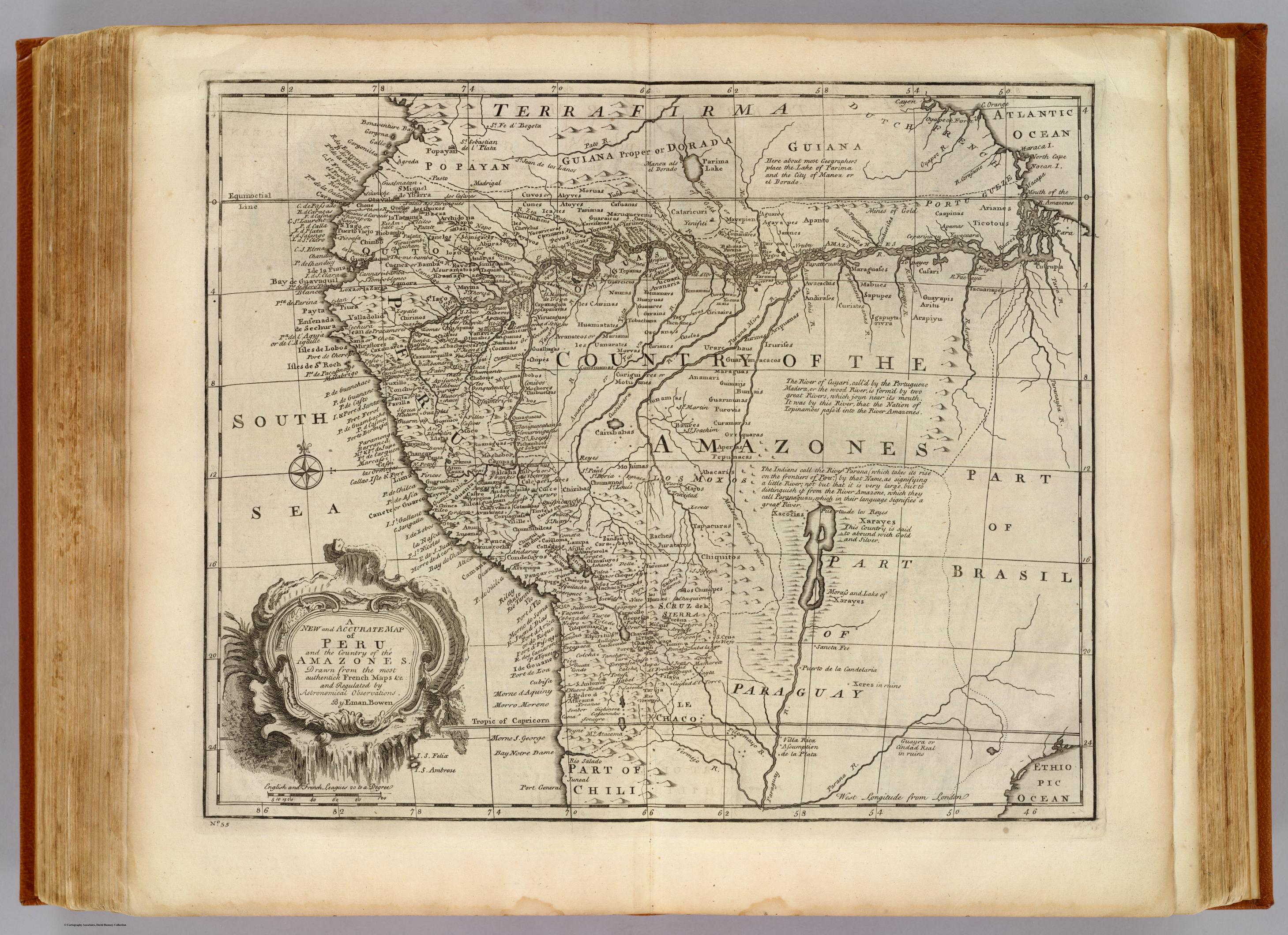
Dispossesions in the Americas

Dispossesions in the Americas

  • Inicio
  • Explorar
  • Autores
  • Sobre
  • Arte
  • Cuerpos
  • Planes de Estudio
  • Herencia Cultural
  • Mapas
  • Territorios
Volver a Explorar

Leyendo en Inglés

Mapa 1747

Peru, Amazones

  • Emanuel Bowen

Publicado: 1747

  • Descargar Imágen
  • Descargar Imágen
Mapa 1747

Peru, Amazones

  • Emanuel Bowen

Publicado: 1747

  • Descargar Imágen

Pueblos

  • MOXOS
  • CURINAS
  • UANARATES
  • CHUNIPES
  • PARIANAS
  • GUARAICAS
  • CANAS
  • CANCHES
  • AVMARAES

Citas

Bowen, Emanuel. Peru, Amazones. Map. London, UK: William Innys [et al.], 1747. Accessed August 7, 2023. https://www.davidrumsey.com/luna/servlet/detail/RUMSEY~8~1~2602~280018:Peru%252C-Amazones-?sort=Pub_List_No_InitialSort&qvq=q:Emanuel%20Bowen,sort:Pub_List_No_InitialSort,lc:RUMSEY~8~1&mi=124&trs=283.

  • Descargar Imágen

Artículos Relacionados

CARTA PLANA DE LA PROVINCIA DE CARACAS Ó VENEZUELA

CARTA PLANA DE LA PROVINCIA DE CARACAS Ó VENEZUELA

Mapa 1787
L'isthme et la baye de Panama et le Darien

L'isthme et la baye de Panama et le Darien

Mapa 1747
A NEW MAP OF BRAZIL, COMPILED FROM THE LATEST Government & other Authentic Surveys.

A NEW MAP OF BRAZIL, COMPILED FROM THE LATEST Government & other Authentic Surveys.

Mapa 1866
Angaité

Angaité

Mapa 2001
Reproduction of a 4th century mural painted on the wall of a royal residence at La Sufricaya in the Peten region of Guatemala. Mural 6 North.

Reproduction of a 4th century mural painted on the wall of a royal residence at La Sufricaya in the Peten region of Guatemala. Mural 6 North.

Mapa 300 - 400
THE AYMARA POLITY OF THE LUPAQA: EASTERN INTER-ANDEAN VALLEY COLONIES UNDER INCA RULE 16TH CENTURY

THE AYMARA POLITY OF THE LUPAQA: EASTERN INTER-ANDEAN VALLEY COLONIES UNDER INCA RULE 16TH CENTURY

Mapa 1560 - 1567
Plano de la mayor parte de la Province de Barinas con agregacion de la ciudad de Guarare y su distrito entre lo Ríos Bocono, y Morador.

Plano de la mayor parte de la Province de Barinas con agregacion de la ciudad de Guarare y su distrito entre lo Ríos Bocono, y Morador.

Mapa 1801
TERRITORIO DEL SEÑORÍO AYMARA DE LOS QARAQARA EN EL SIGLO XVI

TERRITORIO DEL SEÑORÍO AYMARA DE LOS QARAQARA EN EL SIGLO XVI

Mapa 1530

Despojos en las Américas

Un Proyecto de

University of Pennsylvania

Copyright 2024

Con el apoyo de

Mellon Foundation

Diseño y Desarrollo del Sitio

Element 84

Créditos Artísticos

Bowen, Emanuel. Peru, Amazones. Map. London, UK: William Innys [et al.], 1747. Accessed August 7, 2023. https://www.davidrumsey.com/luna/servlet/detail/RUMSEY~8~1~2602~280018:Peru%252C-Amazones-?sort=Pub_List_No_InitialSort&qvq=q:Emanuel%20Bowen,sort:Pub_List_No_InitialSort,lc:RUMSEY~8~1&mi=124&trs=283.

Páginas del Sitio

  • Inicio
  • Explorar
  • Autores
  • Sobre
  • Arte
  • Cuerpos
  • Planes de Estudio
  • Herencia Cultural
  • Mapas
  • Territorios