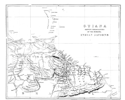
Dispossesions in the Americas

Dispossesions in the Americas

  • Inicio
  • Explorar
  • Autores
  • Sobre
  • Arte
  • Cuerpos
  • Planes de Estudio
  • Herencia Cultural
  • Mapas
  • Territorios
Volver a Explorar

Leyendo en Inglés

Mapa 1800 - 1899

Carte geographique, statistique et historique de la Guyane.

  • Buchon, J. A. C.;Carey, H. C.

Publicado: 1825

  • Descargar Imágen
  • Descargar Imágen
Mapa 1800 - 1899

Carte geographique, statistique et historique de la Guyane.

  • Buchon, J. A. C.;Carey, H. C.

Publicado: 1825

  • Descargar Imágen

Pueblos

  • ACOQUAS
  • ACURIAS
  • AMICOUANES
  • APAMAS
  • ARAMICHAUX
  • ARINACOTOS
  • ARWACAS
  • ATURAYOS
  • BAPIDANOS
  • CARPINAS
  • CONANI
  • CONDURUSES
  • COPARIPUCU
  • CUNURIS
  • EMERILLONS
  • GALIBIS
  • GUACABAYOS
  • KIRIKIRISCOTOS
  • MACUSIS
  • MERCIOUX
  • NORAGUES
  • PALICOURS
  • PARABAYANES
  • PARAGUANAS
  • PARAVENAS
  • PIRIOUS
  • ROUCOUYENNES
  • UAPISANA
  • TARUMAS
  • TUHERE

Citas

Buchon, J. A. C., Carey, H. C., Guyanes. David Rumsay Map Collection. Accessed, August 4, 2023. https://www.davidrumsey.com/luna/servlet/detail/RUMSEY~8~1~34440~1180052:Guyanes

  • Descargar Imágen

Artículos Relacionados

LOCALIZACIÓN DE LOS PRINCIPALES ASENTAMIENTOS TICUNAS

LOCALIZACIÓN DE LOS PRINCIPALES ASENTAMIENTOS TICUNAS

Mapa 2000
Entree de la Riviere d'Aprouak situee dans la Guyane

Entree de la Riviere d'Aprouak situee dans la Guyane

Mapa 1767
Carte 5: Le pays Wayãpi: Région méridionale

Carte 5: Le pays Wayãpi: Région méridionale

Mapa 1760 - 1790
AMER. MÈR. PARTIE DE LA PLATA. N. 31.

AMER. MÈR. PARTIE DE LA PLATA. N. 31.

Mapa 1825
‘INDIAN ROYAL TOWNS’ (REDUCCIONES) AND SACRED SPACES UNDER SPANISH COLONIAL RULE IN THE TERRITORY OF THE PRE-COLONIAL AYMARA POLITY OF THE PAKAXA IN THE LATE 16TH CENTURY

‘INDIAN ROYAL TOWNS’ (REDUCCIONES) AND SACRED SPACES UNDER SPANISH COLONIAL RULE IN THE TERRITORY OF THE PRE-COLONIAL AYMARA POLITY OF THE PAKAXA IN THE LATE 16TH CENTURY

Mapa 1570 - 1650
The Barima River as depicted on Dixon's compass traverse and the AGS million-scale map published in 1940 (bottom)

The Barima River as depicted on Dixon's compass traverse and the AGS million-scale map published in 1940 (bottom)

Mapa 1895
Guiana siue Amazonum Regio.

Guiana siue Amazonum Regio.

Mapa 1600 - 1699
L'Isola Cuba è piu Settetrioal'della Spagnolei et è acor essa molto abodate di zuccaro, cottone, oro et altre cose simili

L'Isola Cuba è piu Settetrioal'della Spagnolei et è acor essa molto abodate di zuccaro, cottone, oro et altre cose simili

Mapa 1500 - 1599

Despojos en las Américas

Un Proyecto de

University of Pennsylvania

Copyright 2024

Con el apoyo de

Mellon Foundation

Diseño y Desarrollo del Sitio

Element 84

Créditos Artísticos

Buchon, J. A. C., Carey, H. C., Guyanes. David Rumsay Map Collection. Accessed, August 4, 2023. https://www.davidrumsey.com/luna/servlet/detail/RUMSEY~8~1~34440~1180052:Guyanes

Páginas del Sitio

  • Inicio
  • Explorar
  • Autores
  • Sobre
  • Arte
  • Cuerpos
  • Planes de Estudio
  • Herencia Cultural
  • Mapas
  • Territorios