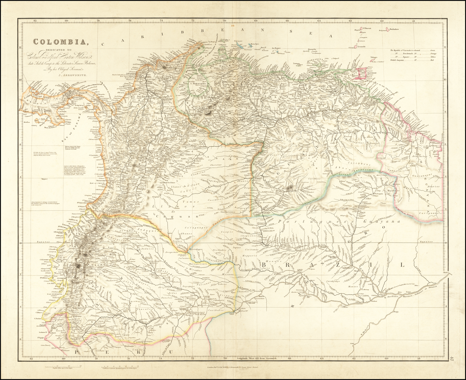
Dispossesions in the Americas

Dispossesions in the Americas

  • Inicio
  • Explorar
  • Autores
  • Sobre
  • Arte
  • Cuerpos
  • Planes de Estudio
  • Herencia Cultural
  • Mapas
  • Territorios
Volver a Explorar

Leyendo en Inglés

Mapa 1800 - 1899

Der Nordliche Theil von Sud-America

  • Perthes, Justus

Publicado: 1828

  • Descargar Imágen
  • Descargar Imágen
Mapa 1800 - 1899

Der Nordliche Theil von Sud-America

  • Perthes, Justus

Publicado: 1828

  • Descargar Imágen

Pueblos

  • ACHAGUAS
  • AEROAS
  • ANNAPUS
  • AREQUENAS
  • ARINACOTOS
  • AROAQUI
  • AROWACKEN
  • BACCAHAS
  • BACCAHIRYS
  • BARBADOS
  • BOROROS
  • BOTOCUDOS
  • CABAHYBAS
  • CABRES
  • CABYXYS
  • CAMACAN
  • CAMARARES
  • CAMECRANS
  • CARAYAS
  • CARIBEN
  • CARIBERIS
  • CATAUXIS
  • CAUTAROS
  • CAYAPOS
  • CHAVANTES
  • CHIQUITOS
  • CHOROTAS
  • CULINOS
  • GALIBIS
  • GUAPINDAYAS
  • GUARUARA
  • GUATOS
  • GUAYCURUS
  • GUEICOS
  • JUMAS
  • MACUS
  • MANIBAS
  • MAXORUNAS
  • MUNDRUCUS
  • MURAS
  • PATACHOS
  • PINTEIRAS
  • PIRIUS
  • PURIS
  • PURUPURUS
  • UGINAS
  • UHAYHAS
  • UXAGUA
  • TACUNHAPEX
  • TOROMONAS
  • TUPINAMBAS
  • XIRIGUANOS
  • XOMANAS
  • YTUCALES

Citas

Perthes, Justus, Der Nordliche Theil von Sud-America, 1828. David Rumsay Map Collection. Accessed, August 3, 2023. https://www.davidrumsey.com/luna/servlet/detail/RUMSEY~8~1~242586~5513106#

  • Descargar Imágen

Artículos Relacionados

Carte Croquis DU COURS DE L'ORÉNOQUE de Bolivar àu Rio Meta

Carte Croquis DU COURS DE L'ORÉNOQUE de Bolivar àu Rio Meta

Mapa 1884
SPECIAL MAP OF BRITISH GUIANA Illustrating the VENEZUELA-GUIANA BOUNDARY DISPUTE

SPECIAL MAP OF BRITISH GUIANA Illustrating the VENEZUELA-GUIANA BOUNDARY DISPUTE

Mapa 1898
DIE REPUBLIK URUGUAY

DIE REPUBLIK URUGUAY

Mapa 1857
Esquema del virreinato del Río de la Plata y sus Intendencias después de la separación de Puno

Esquema del virreinato del Río de la Plata y sus Intendencias después de la separación de Puno

Mapa 1796
INDIAN PEOPLES OF VENEZUELA AND ADJACENT AREAS

INDIAN PEOPLES OF VENEZUELA AND ADJACENT AREAS

Mapa 1995
Indigenous provinces in El Salvador around 1500. (Adapted from Fowler 1989140-141, figure 5, with additional information from Lehman 1920:719, with modifications by the author.)

Indigenous provinces in El Salvador around 1500. (Adapted from Fowler 1989140-141, figure 5, with additional information from Lehman 1920:719, with modifications by the author.)

Mapa 1500
Tribes of Chile and Northwest Argentina

Tribes of Chile and Northwest Argentina

Mapa
"Territorio Indígena Abrojo Montezuma (Ngöbes)"

"Territorio Indígena Abrojo Montezuma (Ngöbes)"

Mapa 2010

Despojos en las Américas

Un Proyecto de

University of Pennsylvania

Copyright 2024

Con el apoyo de

Mellon Foundation

Diseño y Desarrollo del Sitio

Element 84

Créditos Artísticos

Perthes, Justus, Der Nordliche Theil von Sud-America, 1828. David Rumsay Map Collection. Accessed, August 3, 2023. https://www.davidrumsey.com/luna/servlet/detail/RUMSEY~8~1~242586~5513106#

Páginas del Sitio

  • Inicio
  • Explorar
  • Autores
  • Sobre
  • Arte
  • Cuerpos
  • Planes de Estudio
  • Herencia Cultural
  • Mapas
  • Territorios