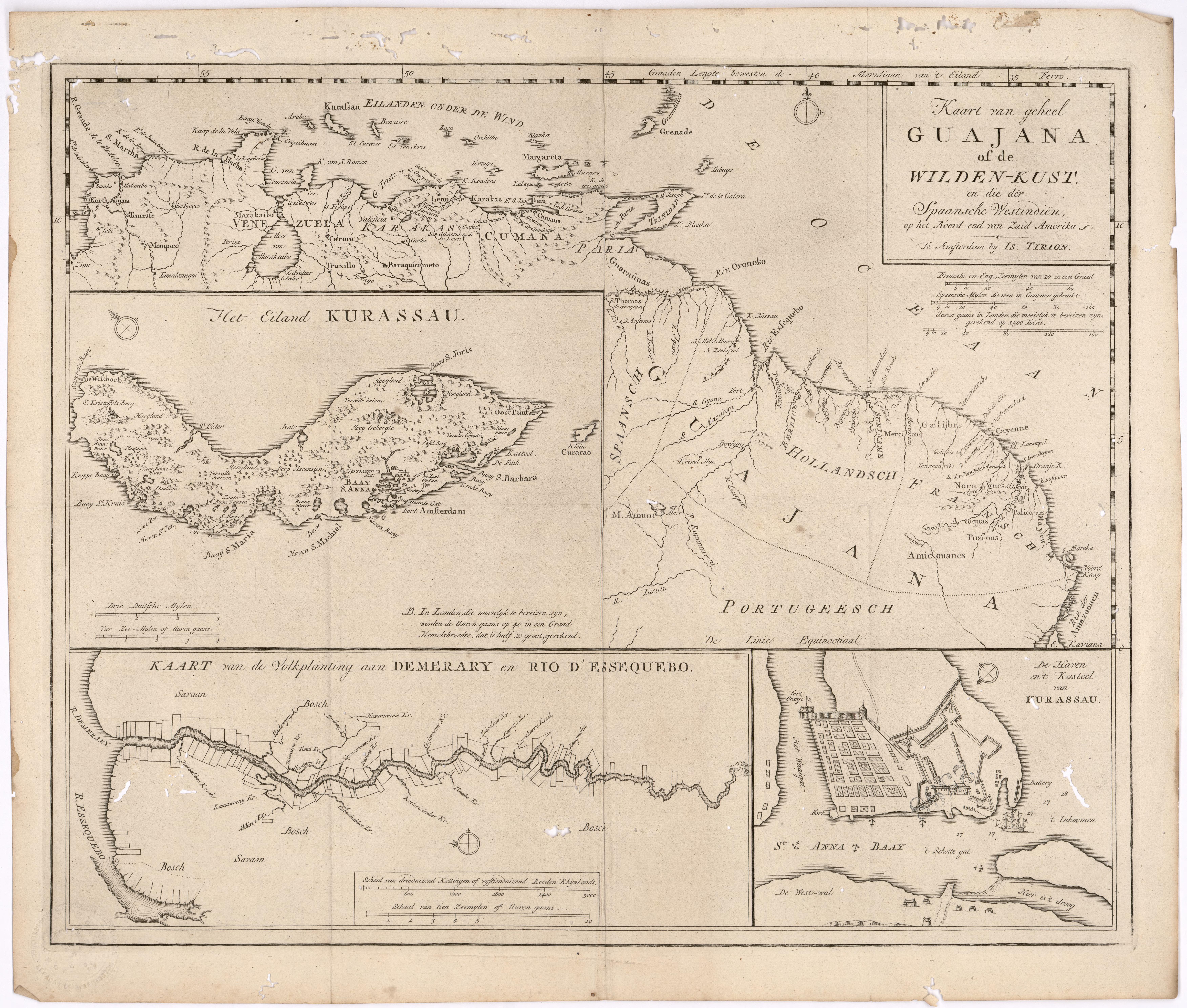
Dispossesions in the Americas

Dispossesions in the Americas

  • Inicio
  • Explorar
  • Autores
  • Sobre
  • Arte
  • Cuerpos
  • Planes de Estudio
  • Herencia Cultural
  • Mapas
  • Territorios
Volver a Explorar

Leyendo en Inglés

Mapa 1700 - 1799

Kart van geheel Guajana of de Wilden-Kust

  • Tirion, Isaak

Publicado: 1720

  • Descargar Imágen
  • Descargar Imágen
Mapa 1700 - 1799

Kart van geheel Guajana of de Wilden-Kust

  • Tirion, Isaak

Publicado: 1720

  • Descargar Imágen

Pueblos

  • ACOQUAS
  • AMICOUANES
  • GALIBIS
  • GUARAUNAS
  • MAYEZ
  • NORAGUES
  • PALICOURS
  • PIRIOUS

Citas

Tirion, Isaak. Map of the Whole of Guiana or the Savage Coast, and the Spanish West Indies at the Northern End of South America. Library of Congress. Accessed, August 3, 2023. https://www.loc.gov/resource/gdcwdl.wdl_11339/?r=0.213,0.044,0.861,0.453,0

  • Descargar Imágen

Artículos Relacionados

Comunidades indígenas del Paraguay

Comunidades indígenas del Paraguay

Mapa 2001
Silver Creek

Silver Creek

Mapa 1997
Jamaican Taíno Village of Maima, St. Ann’s Bay, Jamaica

Jamaican Taíno Village of Maima, St. Ann’s Bay, Jamaica

Mapa 1500 - 1599
Mapa de las regiones de Neiva, Timaná, Plata y Caloto, en la vertiente izquierda del Magdalena

Mapa de las regiones de Neiva, Timaná, Plata y Caloto, en la vertiente izquierda del Magdalena

Mapa 1777
TERRARUM S: MICHAELIS oppidi Americae meridionalis in provincia olim Tape dicta, trans Flumen Vruguai siti, cum adjacentibus simul aliorum oppidorum terris & vicinia Lusitanorum, accurata descriptio.

TERRARUM S: MICHAELIS oppidi Americae meridionalis in provincia olim Tape dicta, trans Flumen Vruguai siti, cum adjacentibus simul aliorum oppidorum terris & vicinia Lusitanorum, accurata descriptio.

Mapa 1750 - 1760
MAP 7.—The Highland tribes of Colombia and Ecuador. (Drawn from data compiled by Gregorio Hernández de Alba;John Murra;Sergio Elías Ortíz;and Henri Lehmann.)

MAP 7.—The Highland tribes of Colombia and Ecuador. (Drawn from data compiled by Gregorio Hernández de Alba;John Murra;Sergio Elías Ortíz;and Henri Lehmann.)

Mapa 1400
Entree de la Riviere d'Aprouak situee dans la Guyane

Entree de la Riviere d'Aprouak situee dans la Guyane

Mapa 1767
Guaraní Occidentales

Guaraní Occidentales

Mapa 2001

Despojos en las Américas

Un Proyecto de

University of Pennsylvania

Copyright 2024

Con el apoyo de

Mellon Foundation

Diseño y Desarrollo del Sitio

Element 84

Créditos Artísticos

Tirion, Isaak. Map of the Whole of Guiana or the Savage Coast, and the Spanish West Indies at the Northern End of South America. Library of Congress. Accessed, August 3, 2023. https://www.loc.gov/resource/gdcwdl.wdl_11339/?r=0.213,0.044,0.861,0.453,0

Páginas del Sitio

  • Inicio
  • Explorar
  • Autores
  • Sobre
  • Arte
  • Cuerpos
  • Planes de Estudio
  • Herencia Cultural
  • Mapas
  • Territorios