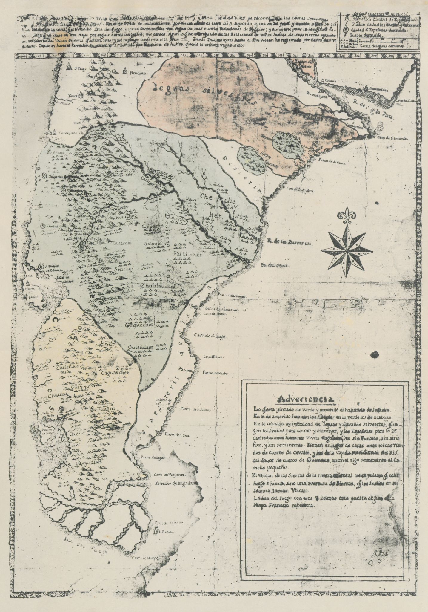
Dispossesions in the Americas

Dispossesions in the Americas

  • Inicio
  • Explorar
  • Autores
  • Sobre
  • Arte
  • Cuerpos
  • Planes de Estudio
  • Herencia Cultural
  • Mapas
  • Territorios
Volver a Explorar

Leyendo en Inglés

Mapa 1700 - 1750

Carta inédita de la extremidad austral de América construída por el P. José Cardiel, S. J. en 1747

  • CARDIEL, JOSE

Publicado: 1747

  • Descargar Imágen
  • Descargar Imágen
Mapa 1700 - 1750

Carta inédita de la extremidad austral de América construída por el P. José Cardiel, S. J. en 1747

  • CARDIEL, JOSE

Publicado: 1747

  • Descargar Imágen

Pueblos

  • POBLACION INFIEL
  • CHE CHE HET
  • EULICHET
  • UAIAUPI
  • TUCUMELEL
  • CHULILAUCHES
  • GEQUECHET
  • QUISUCHER
  • LOYUS
  • CHELEN
  • CHULILA
  • QUEYJU
  • SEHUAGNI
  • QUEYUANES

Cita

Cardiel, Jose, and Guillermo Furlong. Carta inédita de la extremidad austral de América construída por el P. José Cardiel, S. J. en 1747. Map. Buenos Aires, Argentina, 1747. Accessed July 9, 2023. https://digital.iai.spk-berlin.de/viewer/image/630121893/1/LOG_0000/.

  • Descargar Imágen

Leyendo en Portugués

Mapa 1700 - 1750

Carta inédita de la extremidad austral de América construída por el P. José Cardiel, S. J. en 1747

  • CARDIEL, JOSE

Publicado: 1747

  • Descargar Imágen

Pueblos

  • POBLACION INFIEL
  • CHE CHE HET
  • EULICHET
  • UAIAUPI
  • TUCUMELEL
  • CHULILAUCHES
  • GEQUECHET
  • QUISUCHER
  • LOYUS
  • CHELEN
  • CHULILA
  • QUEYJU
  • SEHUAGNI
  • QUEYUANES

Cita

Cardiel, Jose, and Guillermo Furlong. Carta inédita de la extremidad austral de América construída por el P. José Cardiel, S. J. en 1747. Map. Buenos Aires, Argentina, 1747. Accessed July 9, 2023. https://digital.iai.spk-berlin.de/viewer/image/630121893/1/LOG_0000/.

  • Descargar Imágen

Artículos Relacionados

Population density of Cuba

Population density of Cuba

Mapa -4000
Map representing the linguistic diversity that existed in Central America and the Gulf of Fonseca at the time of contact with the Spanish

Map representing the linguistic diversity that existed in Central America and the Gulf of Fonseca at the time of contact with the Spanish

Mapa 1522
Plan pour ouvrir une communication de la mer du Nord á la mer du Sud par la riviére San Juan;le lac de Nicaragua et la baie del Papagaye.

Plan pour ouvrir une communication de la mer du Nord á la mer du Sud par la riviére San Juan;le lac de Nicaragua et la baie del Papagaye.

Mapa 1700
Seropositivo - No positivo

Seropositivo - No positivo

Obra de Arte
Chinantec Municipios, 1950

Chinantec Municipios, 1950

Mapa 1950
The Tribes of Southern South America;at the first European contact period

The Tribes of Southern South America;at the first European contact period

Mapa 1512
Relación Geográfica de Zapotitlán

Relación Geográfica de Zapotitlán

Mapa 1579
The Geography of Peninsular Languages

The Geography of Peninsular Languages

Mapa 1994

Despojos en las Américas

Un Proyecto de

University of Pennsylvania

Copyright 2024

Con el apoyo de

Mellon Foundation

Diseño y Desarrollo del Sitio

Element 84

Créditos Artísticos

Cardiel, Jose, and Guillermo Furlong. Carta inédita de la extremidad austral de América construída por el P. José Cardiel, S. J. en 1747. Map. Buenos Aires, Argentina, 1747. Accessed July 9, 2023. https://digital.iai.spk-berlin.de/viewer/image/630121893/1/LOG_0000/.

Páginas del Sitio

  • Inicio
  • Explorar
  • Autores
  • Sobre
  • Arte
  • Cuerpos
  • Planes de Estudio
  • Herencia Cultural
  • Mapas
  • Territorios