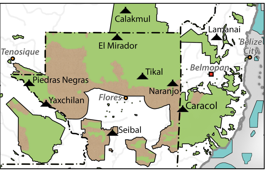
Dispossesions in the Americas

Dispossesions in the Americas

  • Inicio
  • Explorar
  • Autores
  • Sobre
  • Arte
  • Cuerpos
  • Planes de Estudio
  • Herencia Cultural
  • Mapas
  • Territorios
Volver a Explorar

Leyendo en Inglés

Mapa 1800 - 1899

Geographisch-statistische und historische Charte von Guyana.

  • Weiland, Carl Ferdinand;Hassel, Georg

Publicado: 1829

  • Descargar Imágen
  • Descargar Imágen
Mapa 1800 - 1899

Geographisch-statistische und historische Charte von Guyana.

  • Weiland, Carl Ferdinand;Hassel, Georg

Publicado: 1829

  • Descargar Imágen

Pueblos

  • ACOQUAS
  • ACURIAS
  • ARAMICHAUX
  • ARUACAS
  • CARIGUANOS
  • GALIBIS
  • GUARANAYAS
  • KYRYKYRYSCOTAS
  • MACUSIS
  • MERILONS
  • OUAYES
  • OYANPIQUES
  • PARABYANASS
  • PIRIUS
  • RECUYENES
  • TUBAYES

Cita

Weiland, Carl Ferdinand, Hassel, Georg, Guyana. David Rumsey Map Collection. Accessed: July 4, 2023. https://www.davidrumsey.com/luna/servlet/detail/RUMSEY~8~1~297504~90069127:Guyana-

  • Descargar Imágen

Leyendo en Portugués

Mapa 1800 - 1899

Geographisch-statistische und historische Charte von Guyana.

  • Weiland, Carl Ferdinand;Hassel, Georg

Publicado: 1829

  • Descargar Imágen

Pueblos

  • ACOQUAS
  • ACURIAS
  • ARAMICHAUX
  • ARUACAS
  • CARIGUANOS
  • GALIBIS
  • GUARANAYAS
  • KYRYKYRYSCOTAS
  • MACUSIS
  • MERILONS
  • OUAYES
  • OYANPIQUES
  • PARABYANASS
  • PIRIUS
  • RECUYENES
  • TUBAYES

Cita

Weiland, Carl Ferdinand, Hassel, Georg, Guyana. David Rumsey Map Collection. Accessed: July 4, 2023. https://www.davidrumsey.com/luna/servlet/detail/RUMSEY~8~1~297504~90069127:Guyana-

  • Descargar Imágen

Artículos Relacionados

Map of deforestation within protected areas in Guatemala and adjoining areas

Map of deforestation within protected areas in Guatemala and adjoining areas

Mapa 2000 - 2100
"Descripción del Valle de Chimo y planisphérica de la Ciudad de Truxillo del Perú".

"Descripción del Valle de Chimo y planisphérica de la Ciudad de Truxillo del Perú".

Mapa 1760
Carta plano de la provincia de la Hacha situada entre las de Santa Marta y Maracaybo

Carta plano de la provincia de la Hacha situada entre las de Santa Marta y Maracaybo

Mapa 1786
FACSIMILE: PART OF AMERICA BY GUSSEFELDT

FACSIMILE: PART OF AMERICA BY GUSSEFELDT

Mapa 1796
FIGURAS DE ORDENAMIENTO TERRITORIAL EN LA SNSM

FIGURAS DE ORDENAMIENTO TERRITORIAL EN LA SNSM

Mapa 2009
CARTA GEOGRAFICA DEL BRESIL

CARTA GEOGRAFICA DEL BRESIL

Mapa 1740
Prehispanic Distribution of the Otomí Family

Prehispanic Distribution of the Otomí Family

Mapa 1969
Mariposa del Desprecio

Mariposa del Desprecio

Obra de Arte

Despojos en las Américas

Un Proyecto de

University of Pennsylvania

Copyright 2024

Con el apoyo de

Mellon Foundation

Diseño y Desarrollo del Sitio

Element 84

Créditos Artísticos

Weiland, Carl Ferdinand, Hassel, Georg, Guyana. David Rumsey Map Collection. Accessed: July 4, 2023. https://www.davidrumsey.com/luna/servlet/detail/RUMSEY~8~1~297504~90069127:Guyana-

Páginas del Sitio

  • Inicio
  • Explorar
  • Autores
  • Sobre
  • Arte
  • Cuerpos
  • Planes de Estudio
  • Herencia Cultural
  • Mapas
  • Territorios