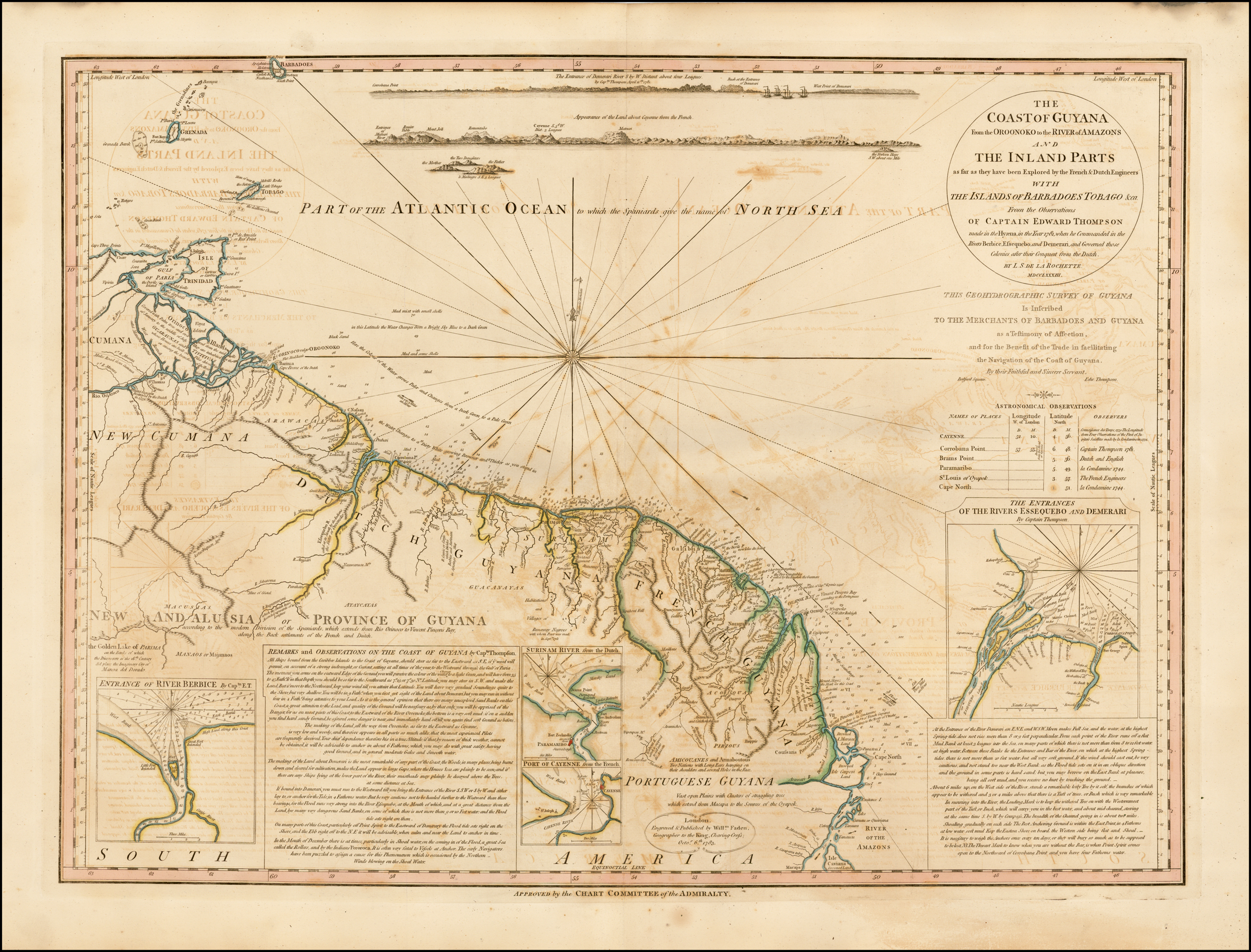
Dispossesions in the Americas

Dispossesions in the Americas

  • Inicio
  • Explorar
  • Autores
  • Sobre
  • Arte
  • Cuerpos
  • Planes de Estudio
  • Herencia Cultural
  • Mapas
  • Territorios
Volver a Explorar

Leyendo en Inglés

Mapa 1781

COAST OF GUYANA FROM THE OROONOKO TO THE RIVER OF AMAZONS AND THE INLAND PARTS AS FAR AS THEY HAVE BEEN EXPLORED BY THE FRENCH & DUTCH ENGINEERS WITH THE ISLANDS OF BARBADOS TOBAGO & CA.

  • L.;DELAROCHETTE

Publicado: 1783

  • Descargar Imágen
  • Descargar Imágen
Mapa 1781

COAST OF GUYANA FROM THE OROONOKO TO THE RIVER OF AMAZONS AND THE INLAND PARTS AS FAR AS THEY HAVE BEEN EXPLORED BY THE FRENCH & DUTCH ENGINEERS WITH THE ISLANDS OF BARBADOS TOBAGO & CA.

  • L.;DELAROCHETTE

Publicado: 1783

  • Descargar Imágen

Pueblos

  • GUARAUNAS
  • TIVITIVAS
  • ARAWACAS
  • GALIBIS
  • NORAGUES
  • GUACANAYAS
  • ATAYCAYAS
  • MACUSIAS
  • MANAOS
  • PALICOURS
  • ACOQUAS
  • MAYEZ
  • PIRIOUS
  • AMICOUANES
  • ARMABOUTOUS
  • COUSSARIS

Cita

Delarochette, L. Coast of Guyana From the Oroonoko to the River of Amazons and The Inland Parts as far as they have been Explored by the French & Dutch Engineers with the Islands of Barbados Tobago &ca. Map. London: William Faden, 1783. Accessed November 6, 2022. https://www.raremaps.com/gallery/detail/42155/the-coast-of-GUY-from-the-oroonoko-to-the-river-of-amazon-faden.

  • Descargar Imágen

Leyendo en Portugués

Mapa 1781

COAST OF GUYANA FROM THE OROONOKO TO THE RIVER OF AMAZONS AND THE INLAND PARTS AS FAR AS THEY HAVE BEEN EXPLORED BY THE FRENCH & DUTCH ENGINEERS WITH THE ISLANDS OF BARBADOS TOBAGO & CA.

  • L.;DELAROCHETTE

Publicado: 1783

  • Descargar Imágen

Pueblos

  • GUARAUNAS
  • TIVITIVAS
  • ARAWACAS
  • GALIBIS
  • NORAGUES
  • GUACANAYAS
  • ATAYCAYAS
  • MACUSIAS
  • MANAOS
  • PALICOURS
  • ACOQUAS
  • MAYEZ
  • PIRIOUS
  • AMICOUANES
  • ARMABOUTOUS
  • COUSSARIS

Cita

Delarochette, L. Coast of Guyana From the Oroonoko to the River of Amazons and The Inland Parts as far as they have been Explored by the French & Dutch Engineers with the Islands of Barbados Tobago &ca. Map. London: William Faden, 1783. Accessed November 6, 2022. https://www.raremaps.com/gallery/detail/42155/the-coast-of-GUY-from-the-oroonoko-to-the-river-of-amazon-faden.

  • Descargar Imágen

Artículos Relacionados

PUEBLO PIMA

PUEBLO PIMA

Mapa 2020
Amazonía

Amazonía

Obra de Arte
Côtes du Brésil de Bahia de todos los Sancts à Spirito Santo

Côtes du Brésil de Bahia de todos los Sancts à Spirito Santo

Mapa 1779
NEW GRANADA

NEW GRANADA

Mapa 1811
COLUMBIA

COLUMBIA

Mapa 1829
BRASIL

BRASIL

Mapa 1800 - 1899
Manuscript Map of the Dagua River Region

Manuscript Map of the Dagua River Region

Mapa 1764
Totocanapan: Approximate Extension in Ancient and Recent Times

Totocanapan: Approximate Extension in Ancient and Recent Times

Mapa 1940

Despojos en las Américas

Un Proyecto de

University of Pennsylvania

Copyright 2024

Con el apoyo de

Mellon Foundation

Diseño y Desarrollo del Sitio

Element 84

Créditos Artísticos

Delarochette, L. Coast of Guyana From the Oroonoko to the River of Amazons and The Inland Parts as far as they have been Explored by the French & Dutch Engineers with the Islands of Barbados Tobago &ca. Map. London: William Faden, 1783. Accessed November 6, 2022. https://www.raremaps.com/gallery/detail/42155/the-coast-of-GUY-from-the-oroonoko-to-the-river-of-amazon-faden.

Páginas del Sitio

  • Inicio
  • Explorar
  • Autores
  • Sobre
  • Arte
  • Cuerpos
  • Planes de Estudio
  • Herencia Cultural
  • Mapas
  • Territorios