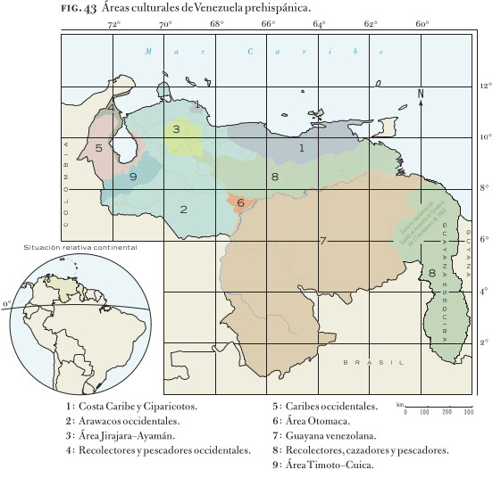
Dispossesions in the Americas

Dispossesions in the Americas

  • Inicio
  • Explorar
  • Autores
  • Sobre
  • Arte
  • Cuerpos
  • Planes de Estudio
  • Herencia Cultural
  • Mapas
  • Territorios
Volver a Explorar

Leyendo en Inglés

Mapa 1830

COLOMBIA AND GUIANA

  • GRIGG;JOHN

Publicado: 1830

  • Descargar Imágen
  • Descargar Imágen
Mapa 1830

COLOMBIA AND GUIANA

  • GRIGG;JOHN

Publicado: 1830

  • Descargar Imágen

Pueblos

  • WAYUU
  • GUARANOS
  • ARAWAK
  • GUAHARIBOS
  • OTOMACO
  • YARURO
  • ACHAGUA
  • BARI
  • BETOYES
  • GALIBAS
  • KIRICOSTOS
  • PARABUZANES

Cita

Grigg, John. Colombia and Guiana. Map. Philadelphia: John Grigg, 1830. Accessed October 2, 2022. https://www.davidrumsey.com/luna/servlet/detail/RUMSEY~8~1~28113~1120245:Colombia,-Guiana-?sort=pub_list_no_initialsort%2Cpub_date%2Cpub_list_no%2Cseries_no.

  • Descargar Imágen

Leyendo en Portugués

Mapa 1830

COLOMBIA AND GUIANA

  • GRIGG;JOHN

Publicado: 1830

  • Descargar Imágen

Pueblos

  • WAYUU
  • GUARANOS
  • ARAWAK
  • GUAHARIBOS
  • OTOMACO
  • YARURO
  • ACHAGUA
  • BARI
  • BETOYES
  • GALIBAS
  • KIRICOSTOS
  • PARABUZANES

Cita

Grigg, John. Colombia and Guiana. Map. Philadelphia: John Grigg, 1830. Accessed October 2, 2022. https://www.davidrumsey.com/luna/servlet/detail/RUMSEY~8~1~28113~1120245:Colombia,-Guiana-?sort=pub_list_no_initialsort%2Cpub_date%2Cpub_list_no%2Cseries_no.

  • Descargar Imágen

Artículos Relacionados

Indigenous provinces in El Salvador around 1500. (Adapted from Fowler 1989140-141, figure 5, with additional information from Lehman 1920:719, with modifications by the author.)

Indigenous provinces in El Salvador around 1500. (Adapted from Fowler 1989140-141, figure 5, with additional information from Lehman 1920:719, with modifications by the author.)

Mapa 1500
Big Falls

Big Falls

Mapa 1997
Áreas culturales de Venezuela prehispánica

Áreas culturales de Venezuela prehispánica

Mapa 1490
The Geography of Peninsular Languages

The Geography of Peninsular Languages

Mapa 1994
Kowkülen [Ser líquido]

Kowkülen [Ser líquido]

Obra de Arte
THE EASTERN BORDERS OF THE QULLASUYU - SOUTHERN DISTRICT OF THE INCA STATE - 16th CENTURY

THE EASTERN BORDERS OF THE QULLASUYU - SOUTHERN DISTRICT OF THE INCA STATE - 16th CENTURY

Mapa 1400 - 1499
Mapa general del Perú

Mapa general del Perú

Mapa 1865
Carte de la coste depuis la Rivière des Amazones jusques à l'Isle de Cayenne / Levée et présentée à Monseigneur le Comte de Pontchartrain Ministre et secrétaire d'Etat ;Par son très-humble et très-obeissant serviteur de Créanton Officier de Marine.

Carte de la coste depuis la Rivière des Amazones jusques à l'Isle de Cayenne / Levée et présentée à Monseigneur le Comte de Pontchartrain Ministre et secrétaire d'Etat ;Par son très-humble et très-obeissant serviteur de Créanton Officier de Marine.

Mapa 1701

Despojos en las Américas

Un Proyecto de

University of Pennsylvania

Copyright 2024

Con el apoyo de

Mellon Foundation

Diseño y Desarrollo del Sitio

Element 84

Créditos Artísticos

Grigg, John. Colombia and Guiana. Map. Philadelphia: John Grigg, 1830. Accessed October 2, 2022. https://www.davidrumsey.com/luna/servlet/detail/RUMSEY~8~1~28113~1120245:Colombia,-Guiana-?sort=pub_list_no_initialsort%2Cpub_date%2Cpub_list_no%2Cseries_no.

Páginas del Sitio

  • Inicio
  • Explorar
  • Autores
  • Sobre
  • Arte
  • Cuerpos
  • Planes de Estudio
  • Herencia Cultural
  • Mapas
  • Territorios