Dispossesions in the Americas

Dispossesions in the Americas

  • Inicio
  • Explorar
  • Autores
  • Sobre
  • Arte
  • Cuerpos
  • Planes de Estudio
  • Herencia Cultural
  • Mapas
  • Territorios
Volver a Explorar

Leyendo en Inglés

Mapa 1900 - 1999

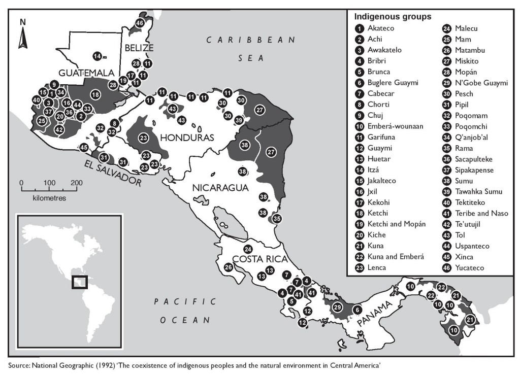
The coexistence of indigenous peoples and the natural environment in Central America

  • NATIONAL GEOGRAPHIC

Publicado: 1992

  • Descargar Imágen
  • Descargar Imágen
Mapa 1900 - 1999

The coexistence of indigenous peoples and the natural environment in Central America

  • NATIONAL GEOGRAPHIC

Publicado: 1992

  • Descargar Imágen

Pueblos

  • AKATECO
  • ACHI
  • AWAKATELO
  • BRIBRI
  • BRUNCA
  • BUGLEREGUAYMI
  • CABECAR
  • CHORTI
  • CHUJ
  • EMBERAWOUNAAN
  • GARIFUNA
  • GUAYMI
  • HUETAR
  • ITZA
  • JAKALTECO
  • JXIL
  • KEKOHI
  • KETCHI
  • MOPAN
  • KICHE
  • KUNA
  • LENCA
  • MALECU
  • MAM
  • MATAMBU
  • MISKITO
  • NGOBEGUAYMI
  • PESCH
  • PIPIL
  • POQOMAM
  • POQOMCHI
  • QANJOBAL
  • RAMA
  • SACAPULTEKE
  • SIPAKAPENSE
  • SUMU
  • TAWAHKASUMU
  • TEKTITEKO
  • TERIBE
  • NASO
  • TEUTUJIL
  • TOL
  • USPANTECO
  • XINCA
  • YUCATECO

Citas

"Indigenous Territories of Central America." The Violence of Development. MAP 1992. Accessed from: https://theviolenceofdevelopment.com/category/chapter-8/indigenous-territories-in-central-america/.
  • Descargar Imágen

Artículos Relacionados

Descricción [sic] Plan del Río Tinto con su Pueblo, Barra y pies de agua que hai como demuestran los números;fortalezas como marca el Abezedario

Descricción [sic] Plan del Río Tinto con su Pueblo, Barra y pies de agua que hai como demuestran los números;fortalezas como marca el Abezedario

Mapa 1743 - 1744
REGIÓN FRONTERA SUR

REGIÓN FRONTERA SUR

Mapa 2000
Carte Croquis DU COURS DE L'ORÉNOQUE de Bolivar àu Rio Meta

Carte Croquis DU COURS DE L'ORÉNOQUE de Bolivar àu Rio Meta

Mapa 1884
Reproduction of a 4th century mural painted on the wall of a royal residence at La Sufricaya in the Peten region of Guatemala. Mural 6 North.

Reproduction of a 4th century mural painted on the wall of a royal residence at La Sufricaya in the Peten region of Guatemala. Mural 6 North.

Mapa 300 - 400
Ancient Chinantla

Ancient Chinantla

Mapa 1962
PRESENT-DAY MAYA LANGUAGE BOUNDARIES OF GUATEMALA

PRESENT-DAY MAYA LANGUAGE BOUNDARIES OF GUATEMALA

Mapa 1961
PUEBLO POPOLOCA

PUEBLO POPOLOCA

Mapa 2020
Terra Indígena Guarani do Aguapeú

Terra Indígena Guarani do Aguapeú

Mapa 2011

Despojos en las Américas

Un Proyecto de

University of Pennsylvania

Copyright 2024

Con el apoyo de

Mellon Foundation

Diseño y Desarrollo del Sitio

Element 84

Créditos Artísticos

“Indigenous Territories of Central America.” The Violence of Development. MAP 1992. Accessed from: https://theviolenceofdevelopment.com/category/chapter-8/indigenous-territories-in-central-america/.
Páginas del Sitio

  • Inicio
  • Explorar
  • Autores
  • Sobre
  • Arte
  • Cuerpos
  • Planes de Estudio
  • Herencia Cultural
  • Mapas
  • Territorios