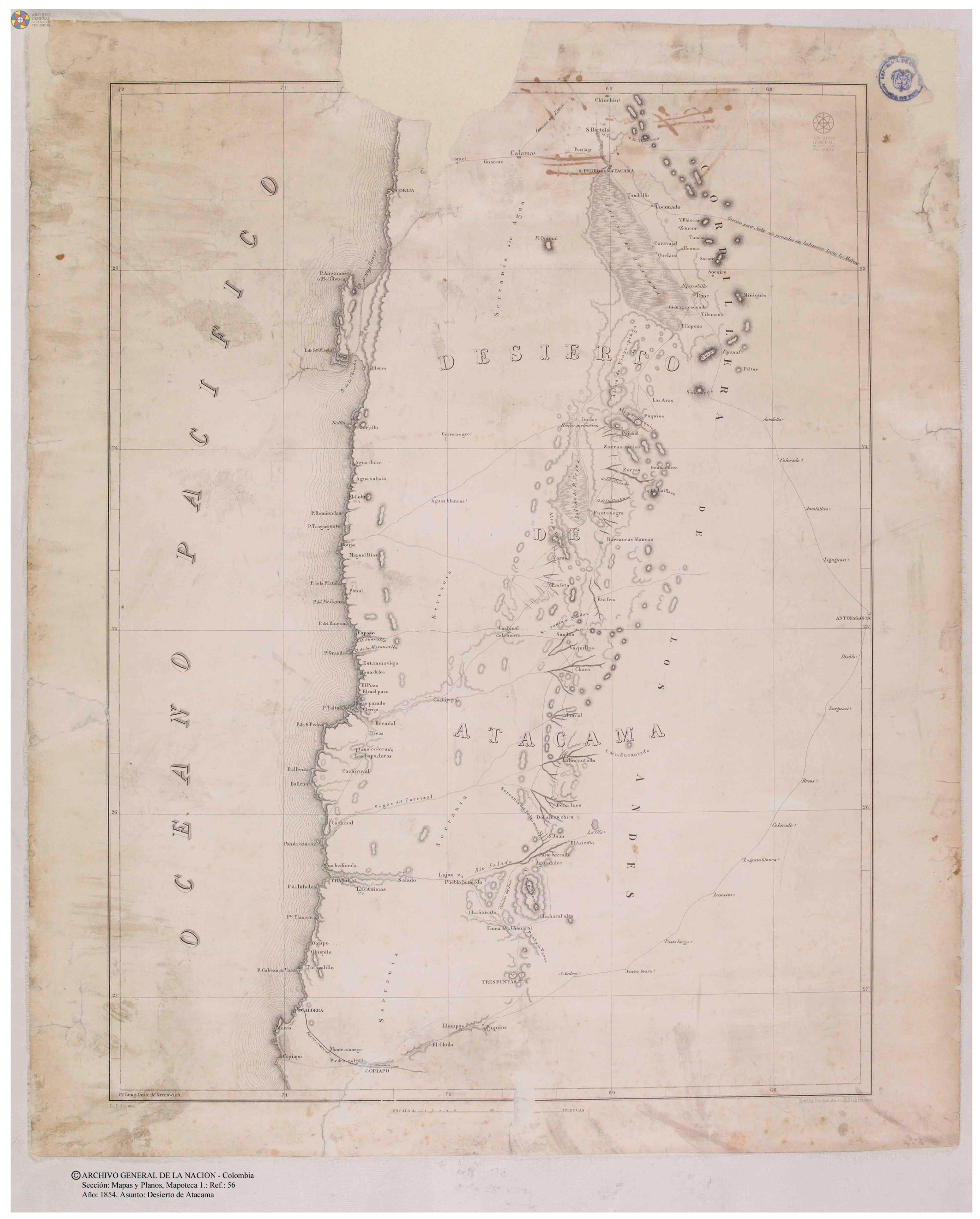
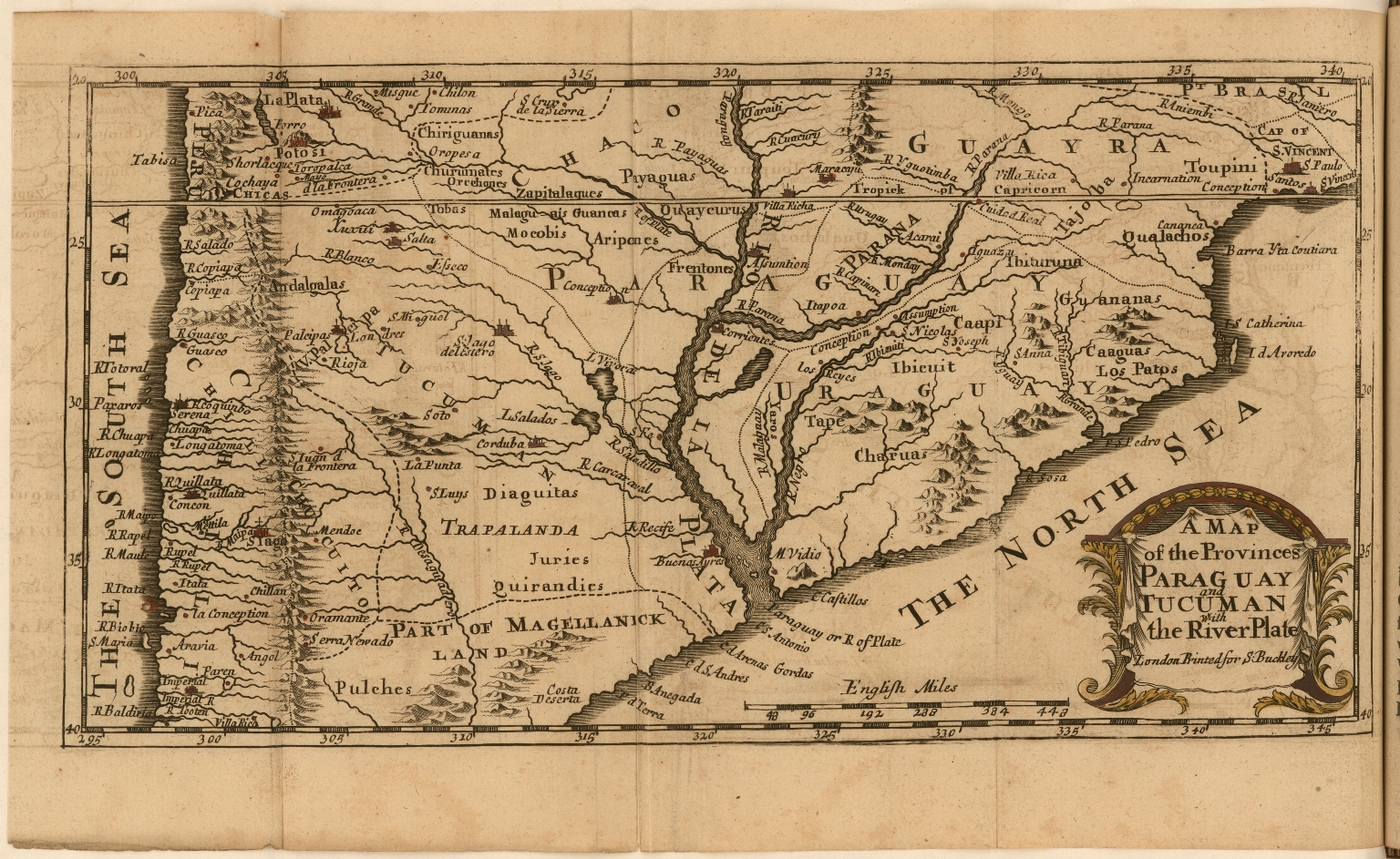
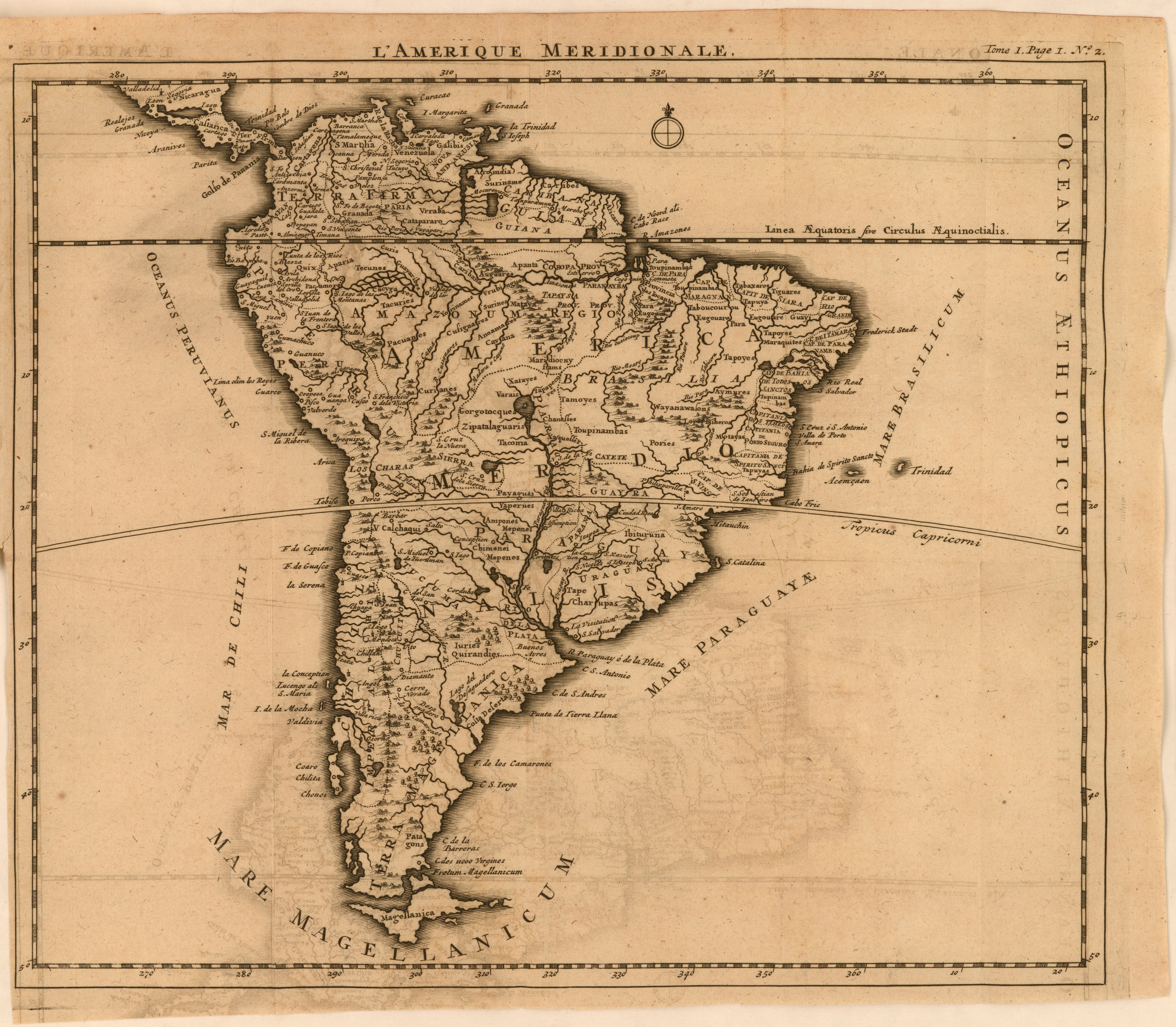
Dispossesions in the Americas

Dispossesions in the Americas

  • Inicio
  • Explorar
  • Autores
  • Sobre
  • Arte
  • Cuerpos
  • Planes de Estudio
  • Herencia Cultural
  • Mapas
  • Territorios
Volver a Explorar

Leyendo en Inglés

Mapa 1650

L'Amerique meridionale

  • Vega;Garcilaso de la

Publicado: 1706

  • Descargar Imágen
  • Descargar Imágen
Mapa 1650

L'Amerique meridionale

  • Vega;Garcilaso de la

Publicado: 1706

  • Descargar Imágen

Pueblos

  • PATAGONS
  • IURIES
  • QUERANDIES
  • CHARRUAS
  • TAPES
  • PAYAGUA
  • CALCHAQUI
  • CHIMONEI
  • MOPONES
  • AMPONES
  • YAPERUES
  • CHARUPAS
  • PORIES
  • MOTAYAS
  • WAYANAWA
  • TUPINAMBAS
  • AYMURES
  • TAPOYES
  • MARAQUITES
  • GUAYI
  • PARA
  • EUGOUARE
  • TAPUYA
  • TABOUCOUROU
  • TABAXARES
  • TIGUARES
  • GALIBIS
  • TOCUNES
  • APARIA
  • GUAYARIBOS
  • TACURIES
  • PACUANES
  • YORINAMES
  • ANOAMARES
  • CAYANA
  • CURIANES
  • XARAYES
  • VARAIS
  • TAPAPECOVES
  • TAMOYES
  • GORGOTOCQUES
  • ZIPATALAGUARIS
  • TACOMA
  • CAYETE
  • PAYAGUAS
  • YAPERUES
  • IBITURUNA

Cita

Vega, Garcilaso de la. "L'Amerique meridionale." Map. 1706. https://jcb.lunaimaging.com/luna/servlet/detail/JCBMAPS~1~1~5541~115901216:L-Amerique-meridionale-?sort=normalized_date%2Cfile_name%2Csource_author%2Csource_title#

  • Descargar Imágen

Leyendo en Portugués

Mapa 1650

L'Amerique meridionale

  • Vega;Garcilaso de la

Publicado: 1706

  • Descargar Imágen

Pueblos

  • PATAGONS
  • IURIES
  • QUERANDIES
  • CHARRUAS
  • TAPES
  • PAYAGUA
  • CALCHAQUI
  • CHIMONEI
  • MOPONES
  • AMPONES
  • YAPERUES
  • CHARUPAS
  • PORIES
  • MOTAYAS
  • WAYANAWA
  • TUPINAMBAS
  • AYMURES
  • TAPOYES
  • MARAQUITES
  • GUAYI
  • PARA
  • EUGOUARE
  • TAPUYA
  • TABOUCOUROU
  • TABAXARES
  • TIGUARES
  • GALIBIS
  • TOCUNES
  • APARIA
  • GUAYARIBOS
  • TACURIES
  • PACUANES
  • YORINAMES
  • ANOAMARES
  • CAYANA
  • CURIANES
  • XARAYES
  • VARAIS
  • TAPAPECOVES
  • TAMOYES
  • GORGOTOCQUES
  • ZIPATALAGUARIS
  • TACOMA
  • CAYETE
  • PAYAGUAS
  • YAPERUES
  • IBITURUNA

Cita

Vega, Garcilaso de la. "L'Amerique meridionale." Map. 1706. https://jcb.lunaimaging.com/luna/servlet/detail/JCBMAPS~1~1~5541~115901216:L-Amerique-meridionale-?sort=normalized_date%2Cfile_name%2Csource_author%2Csource_title#

  • Descargar Imágen

Artículos Relacionados

Chile: Desierto de Atacama

Chile: Desierto de Atacama

Mapa 1854
MAPA DE SAN MATEO IXTLAHUACAN

MAPA DE SAN MATEO IXTLAHUACAN

Mapa 1500 - 1599
A Map of the Provinces Paraguay and Tucuman with the
     River Plate

A Map of the Provinces Paraguay and Tucuman with the River Plate

Mapa 1698
The indigenous language groups  of Baja California at contact

The indigenous language groups of Baja California at contact

Mapa 1530
Colombia Prima or South America drawn from the large map in eight sheets by Louis Stanislas D'Arcy Delarochette

Colombia Prima or South America drawn from the large map in eight sheets by Louis Stanislas D'Arcy Delarochette

Mapa 1811
Boom Creek Village

Boom Creek Village

Mapa 1997
QUINTANA ROO

QUINTANA ROO

Mapa 2015
Indian Languages, Late 16th Century, (According to Ponce and Viana).

Indian Languages, Late 16th Century, (According to Ponce and Viana).

Mapa 1500

Despojos en las Américas

Un Proyecto de

University of Pennsylvania

Copyright 2024

Con el apoyo de

Mellon Foundation

Diseño y Desarrollo del Sitio

Element 84

Créditos Artísticos

Vega, Garcilaso de la. “L’Amerique meridionale.” Map. 1706. https://jcb.lunaimaging.com/luna/servlet/detail/JCBMAPS~1~1~5541~115901216:L-Amerique-meridionale-?sort=normalized_date%2Cfile_name%2Csource_author%2Csource_title#

Páginas del Sitio

  • Inicio
  • Explorar
  • Autores
  • Sobre
  • Arte
  • Cuerpos
  • Planes de Estudio
  • Herencia Cultural
  • Mapas
  • Territorios