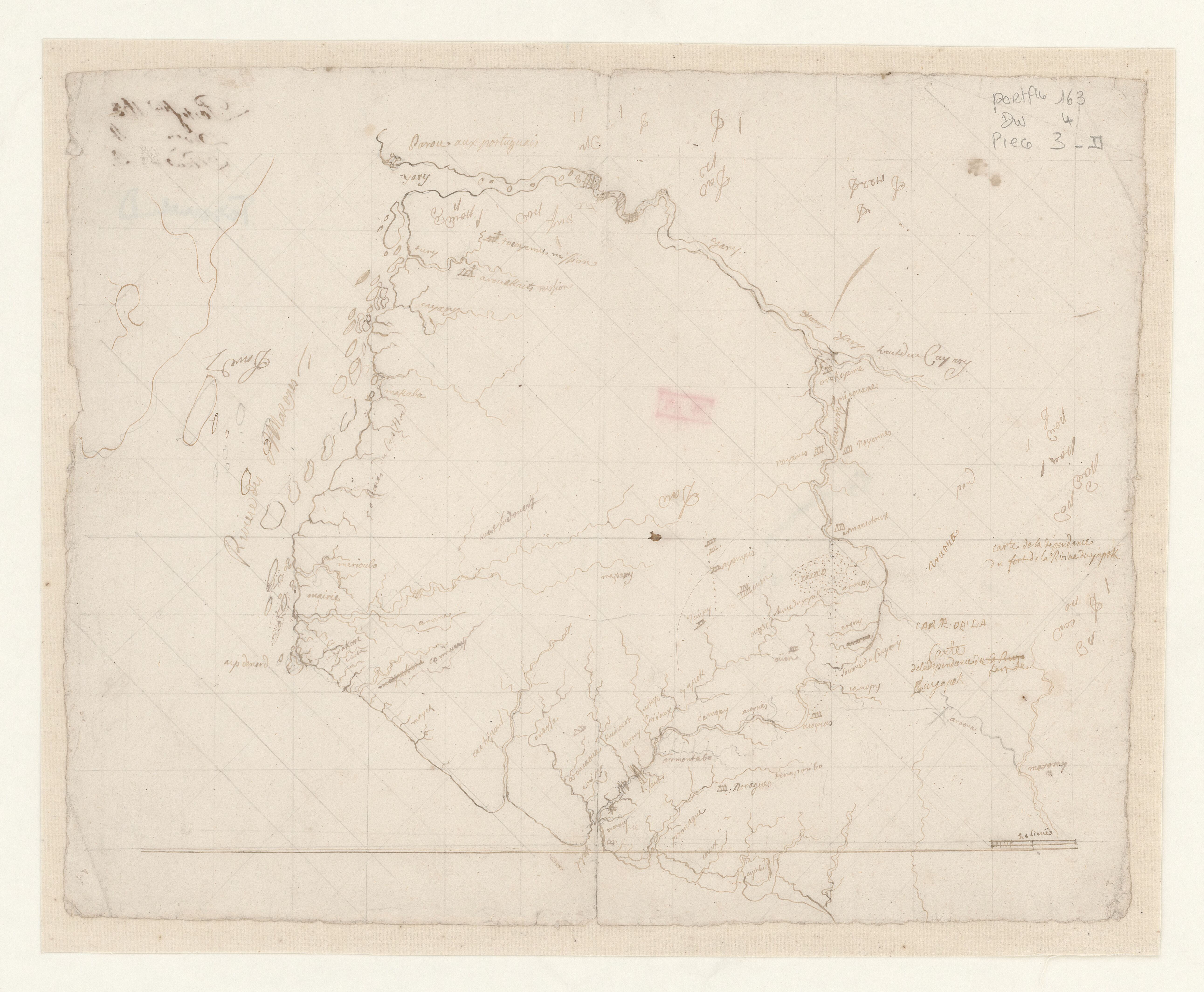
Dispossesions in the Americas

Dispossesions in the Americas

  • Inicio
  • Explorar
  • Autores
  • Sobre
  • Arte
  • Cuerpos
  • Planes de Estudio
  • Herencia Cultural
  • Mapas
  • Territorios
Volver a Explorar

Leyendo en Inglés

Mapa 1600 - 1799

Carte de la dépendance du fort de la rivière d'Oyapok

    Publicado: 1600-1799

    • Descargar Imágen
    • Descargar Imágen
    Mapa 1600 - 1799

    Carte de la dépendance du fort de la rivière d'Oyapok

      Publicado: 1600-1799

      • Descargar Imágen

      Pueblos

      • NORAGUES
      • AROQUAS
      • TARIPUY
      • OYAMPIS
      • ARMANTOTOUX
      • NOYENNES
      • COUYARY
      • AMICOUANES
      • OROKOYENNE
      • TOCOYENNE
      • AROUAKAITS
      • AROUCAOUE

      Citas

      "Carte de la dépendance du fort de la rivière d'Oyapok." Map. Accessed August 11, 2023. https://gallica.bnf.fr/ark:/12148/btv1b53103526x/f1.item.

      • Descargar Imágen

      Artículos Relacionados

      Outlines of the physical and political division of South America: Delineated by A. Arrowsmith partly from scarce and original documents, published before the year 1806 but principally from manuscript maps & surveys made between the years 1771 and 1806, corrected from accurate astronomical observations to 1810.

      Outlines of the physical and political division of South America: Delineated by A. Arrowsmith partly from scarce and original documents, published before the year 1806 but principally from manuscript maps & surveys made between the years 1771 and 1806, corrected from accurate astronomical observations to 1810.

      Mapa 1800 - 1899
      Terra Indígena Bananal (Peruíbe)

      Terra Indígena Bananal (Peruíbe)

      Mapa 2012
      PUEBLO TARAHUMARA

      PUEBLO TARAHUMARA

      Mapa 2020
      PL 38: Guyane française.

      PL 38: Guyane française.

      Mapa 1929
      Población mahkurawe (guarijío) en 2010

      Población mahkurawe (guarijío) en 2010

      Mapa 2010
      The coexistence of indigenous peoples and the natural environment in Central America

      The coexistence of indigenous peoples and the natural environment in Central America

      Mapa 1900 - 1999
      Localización de las áreas culturales de Venezuela prehispánica

      Localización de las áreas culturales de Venezuela prehispánica

      Mapa 1490
      Carta del Virreynato de Santafe de Bogota: Copia de la de Mr. D'Anville

      Carta del Virreynato de Santafe de Bogota: Copia de la de Mr. D'Anville

      Mapa 1776

      Despojos en las Américas

      Un Proyecto de

      University of Pennsylvania

      Copyright 2024

      Con el apoyo de

      Mellon Foundation

      Diseño y Desarrollo del Sitio

      Element 84

      Créditos Artísticos

      “Carte de la dépendance du fort de la rivière d’Oyapok.” Map. Accessed August 11, 2023. https://gallica.bnf.fr/ark:/12148/btv1b53103526x/f1.item.

      Páginas del Sitio

      • Inicio
      • Explorar
      • Autores
      • Sobre
      • Arte
      • Cuerpos
      • Planes de Estudio
      • Herencia Cultural
      • Mapas
      • Territorios