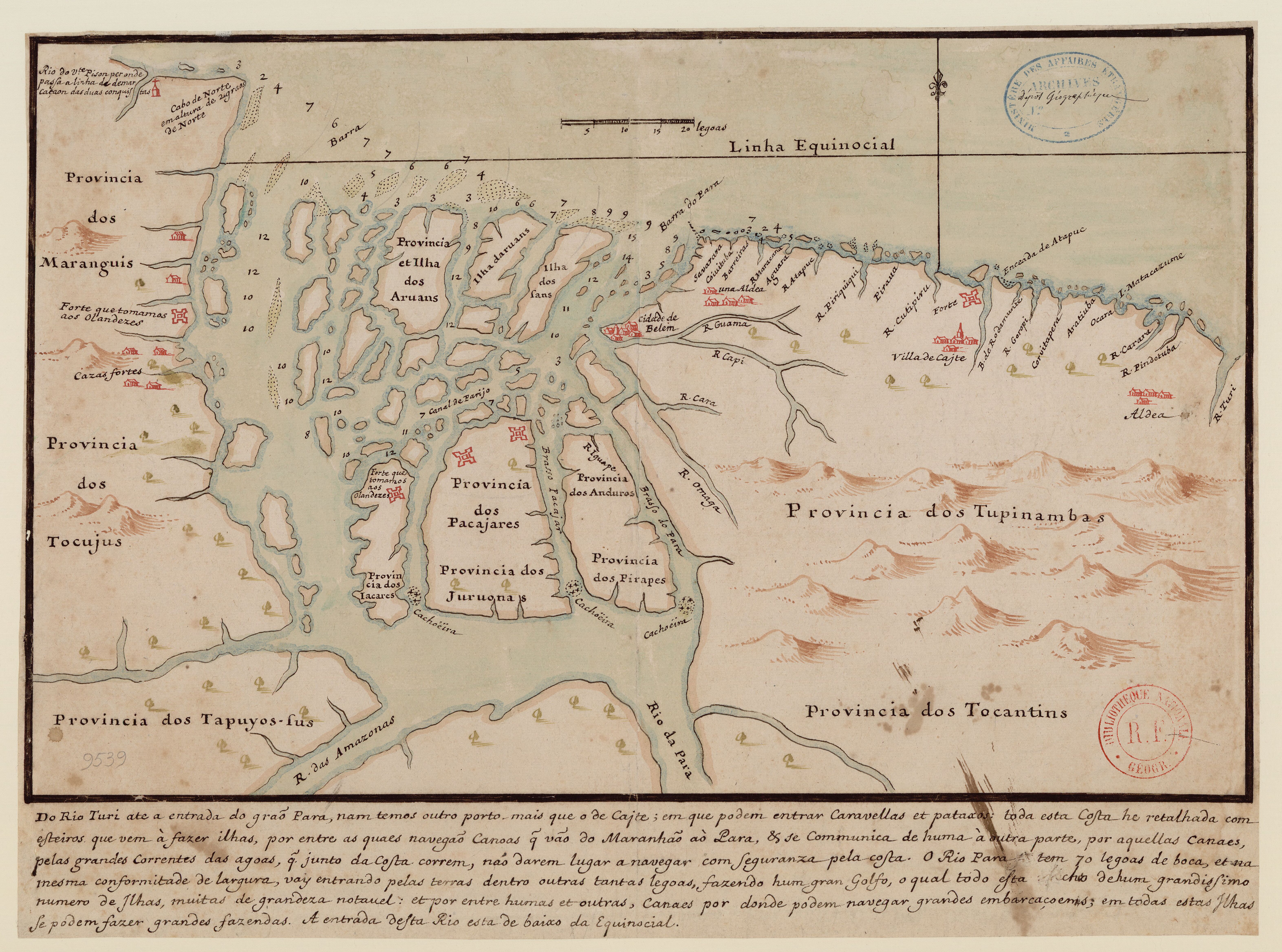
Dispossesions in the Americas

Dispossesions in the Americas

  • Inicio
  • Explorar
  • Autores
  • Sobre
  • Arte
  • Cuerpos
  • Planes de Estudio
  • Herencia Cultural
  • Mapas
  • Territorios
Volver a Explorar

Leyendo en Inglés

Mapa 1600 - 1640

Do Rio Turi ate a entrada do Grao Para

  • ALBERNAZ, JOAO TEIXEIRA

Publicado: 1640

  • Descargar Imágen
  • Descargar Imágen
Mapa 1600 - 1640

Do Rio Turi ate a entrada do Grao Para

  • ALBERNAZ, JOAO TEIXEIRA

Publicado: 1640

  • Descargar Imágen

Pueblos

  • TUPINAMBAS
  • TOCANTINS
  • PACAJARES
  • JURUONAS
  • ANDUROS
  • PIRAPES
  • TAPUYOS
  • TOCUJUS
  • MARANGUIS
  • ARUANS
  • IACARES

Cita

Albernaz, João Teixeira. "Do Rio Turi ate a entrada do Grao Para." Map. 1640. Accessed August 2, 2023. https://gallica.bnf.fr/ark:/12148/btv1b8596748w?rk=3540790;0.

  • Descargar Imágen

Leyendo en Portugués

Mapa 1600 - 1640

Do Rio Turi ate a entrada do Grao Para

  • ALBERNAZ, JOAO TEIXEIRA

Publicado: 1640

  • Descargar Imágen

Pueblos

  • TUPINAMBAS
  • TOCANTINS
  • PACAJARES
  • JURUONAS
  • ANDUROS
  • PIRAPES
  • TAPUYOS
  • TOCUJUS
  • MARANGUIS
  • ARUANS
  • IACARES

Cita

Albernaz, João Teixeira. "Do Rio Turi ate a entrada do Grao Para." Map. 1640. Accessed August 2, 2023. https://gallica.bnf.fr/ark:/12148/btv1b8596748w?rk=3540790;0.

  • Descargar Imágen

Artículos Relacionados

INTENDENCIA DE ZACATECAS

INTENDENCIA DE ZACATECAS

Mapa 1800
Village Groupings

Village Groupings

Mapa 1997
Guatemala: From Official and Other Sources

Guatemala: From Official and Other Sources

Mapa 1900 - 1902
Outlines of the physical and political division of South America: Delineated by A. Arrowsmith partly from scarce and original documents, published before the year 1806 but principally from manuscript maps & surveys made between the years 1771 and 1806, corrected from accurate astronomical observations to 1810.

Outlines of the physical and political division of South America: Delineated by A. Arrowsmith partly from scarce and original documents, published before the year 1806 but principally from manuscript maps & surveys made between the years 1771 and 1806, corrected from accurate astronomical observations to 1810.

Mapa 1800 - 1899
Part of the Southwest 1600-1750 Showing Locations of "Unknown Athapaskans"

Part of the Southwest 1600-1750 Showing Locations of "Unknown Athapaskans"

Mapa 1600 - 1750
Mapa que comprehende las Misiones de Moxos y Chiquitos.

Mapa que comprehende las Misiones de Moxos y Chiquitos.

Mapa 1763 - 1766
El mundo entero está mirando: Todas las mujeres son bienvenidas

El mundo entero está mirando: Todas las mujeres son bienvenidas

Obra de Arte
LENGUAS INDIGENAS AMAZONIA

LENGUAS INDIGENAS AMAZONIA

Mapa 2008

Despojos en las Américas

Un Proyecto de

University of Pennsylvania

Copyright 2024

Con el apoyo de

Mellon Foundation

Diseño y Desarrollo del Sitio

Element 84

Créditos Artísticos

Albernaz, João Teixeira. “Do Rio Turi ate a entrada do Grao Para.” Map. 1640. Accessed August 2, 2023. https://gallica.bnf.fr/ark:/12148/btv1b8596748w?rk=3540790;0.

Páginas del Sitio

  • Inicio
  • Explorar
  • Autores
  • Sobre
  • Arte
  • Cuerpos
  • Planes de Estudio
  • Herencia Cultural
  • Mapas
  • Territorios