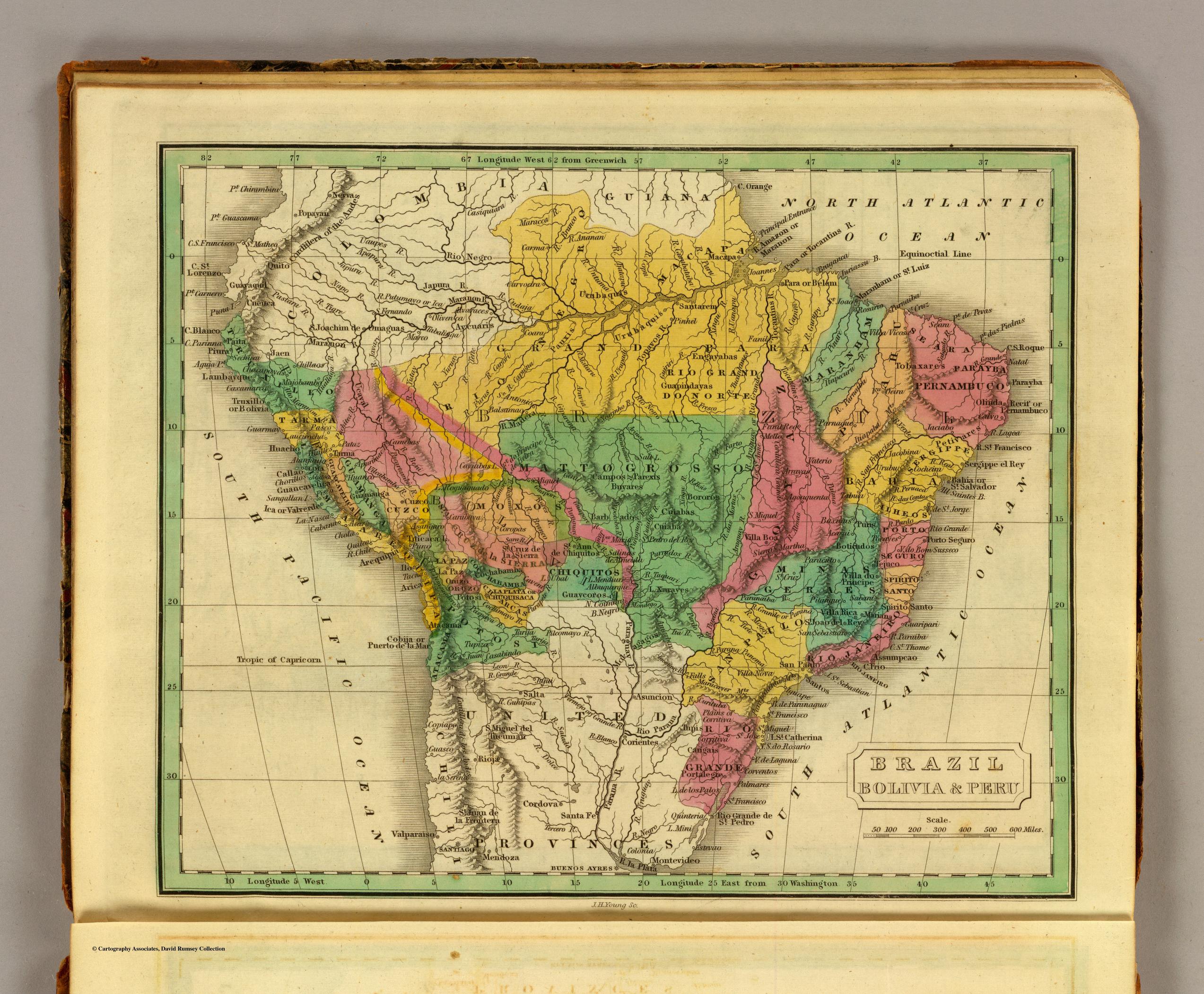
Dispossesions in the Americas

Dispossesions in the Americas

  • Inicio
  • Explorar
  • Autores
  • Sobre
  • Arte
  • Cuerpos
  • Planes de Estudio
  • Herencia Cultural
  • Mapas
  • Territorios
Volver a Explorar

Leyendo en Inglés

Mapa 1830

BRAZIL BOLIVIA & PERU

  • GRIGG, JOHN

Publicado: 1830

  • Descargar Imágen
  • Descargar Imágen
Mapa 1830

BRAZIL BOLIVIA & PERU

  • GRIGG, JOHN

Publicado: 1830

  • Descargar Imágen

Pueblos

  • PAUXIS
  • URUBAQUIS
  • TOBAXARES
  • ENGAYABAS
  • GUAPINDAYAS
  • PAREXIS
  • BUYARES
  • BARBADOS
  • BOROROS
  • CUIABAS
  • PETIVARES
  • PURIS
  • BOTICUDOS
  • GUAYCOROS
  • MOLAGAGOS
  • TUPIS
  • CARIGAIS

Cita

Grigg, John. Brazil Bolivia & Peru. Map. Philadelphia: John Grigg, 1830. Accessed July 27, 2023. https://www.davidrumsey.com/luna/servlet/detail/RUMSEY~8~1~28114~1120246#.

  • Descargar Imágen

Leyendo en Portugués

Mapa 1830

BRAZIL BOLIVIA & PERU

  • GRIGG, JOHN

Publicado: 1830

  • Descargar Imágen

Pueblos

  • PAUXIS
  • URUBAQUIS
  • TOBAXARES
  • ENGAYABAS
  • GUAPINDAYAS
  • PAREXIS
  • BUYARES
  • BARBADOS
  • BOROROS
  • CUIABAS
  • PETIVARES
  • PURIS
  • BOTICUDOS
  • GUAYCOROS
  • MOLAGAGOS
  • TUPIS
  • CARIGAIS

Cita

Grigg, John. Brazil Bolivia & Peru. Map. Philadelphia: John Grigg, 1830. Accessed July 27, 2023. https://www.davidrumsey.com/luna/servlet/detail/RUMSEY~8~1~28114~1120246#.

  • Descargar Imágen

Artículos Relacionados

PUEBLO TLAHUICA

PUEBLO TLAHUICA

Mapa 2020
PUEBLO TOTONACO

PUEBLO TOTONACO

Mapa 2020
PRINCIPALES GRUPOS ÉTNICOS DEL TERRITORIO ESEQUIBO

PRINCIPALES GRUPOS ÉTNICOS DEL TERRITORIO ESEQUIBO

Mapa 1979
Colombia Prima or South America drawn from the large map in eight sheets by Louis Stanislas D'Arcy Delarochette

Colombia Prima or South America drawn from the large map in eight sheets by Louis Stanislas D'Arcy Delarochette

Mapa 1811
[Embouchures de l'Oyapock et de diverses rivières].

[Embouchures de l'Oyapock et de diverses rivières].

Mapa 1700 - 1799
GOVERNMENT OF CARACAS;WITH GUIANA.

GOVERNMENT OF CARACAS;WITH GUIANA.

Mapa 1812
ATLAS DE LOS PUEBLOS INDÍGENAS DE MEXICO

ATLAS DE LOS PUEBLOS INDÍGENAS DE MEXICO

Mapa 2015
Paraguay Verdeelt in zyn voornaamste deelen Volgens de
     laatste reisbeschryvinge door N. Sanson d.'Abbeville, Geographe ordre. du
     Ro

Paraguay Verdeelt in zyn voornaamste deelen Volgens de laatste reisbeschryvinge door N. Sanson d.'Abbeville, Geographe ordre. du Ro

Mapa 1600 - 1667

Despojos en las Américas

Un Proyecto de

University of Pennsylvania

Copyright 2024

Con el apoyo de

Mellon Foundation

Diseño y Desarrollo del Sitio

Element 84

Créditos Artísticos

Grigg, John. Brazil Bolivia & Peru. Map. Philadelphia: John Grigg, 1830. Accessed July 27, 2023. https://www.davidrumsey.com/luna/servlet/detail/RUMSEY~8~1~28114~1120246#.

Páginas del Sitio

  • Inicio
  • Explorar
  • Autores
  • Sobre
  • Arte
  • Cuerpos
  • Planes de Estudio
  • Herencia Cultural
  • Mapas
  • Territorios