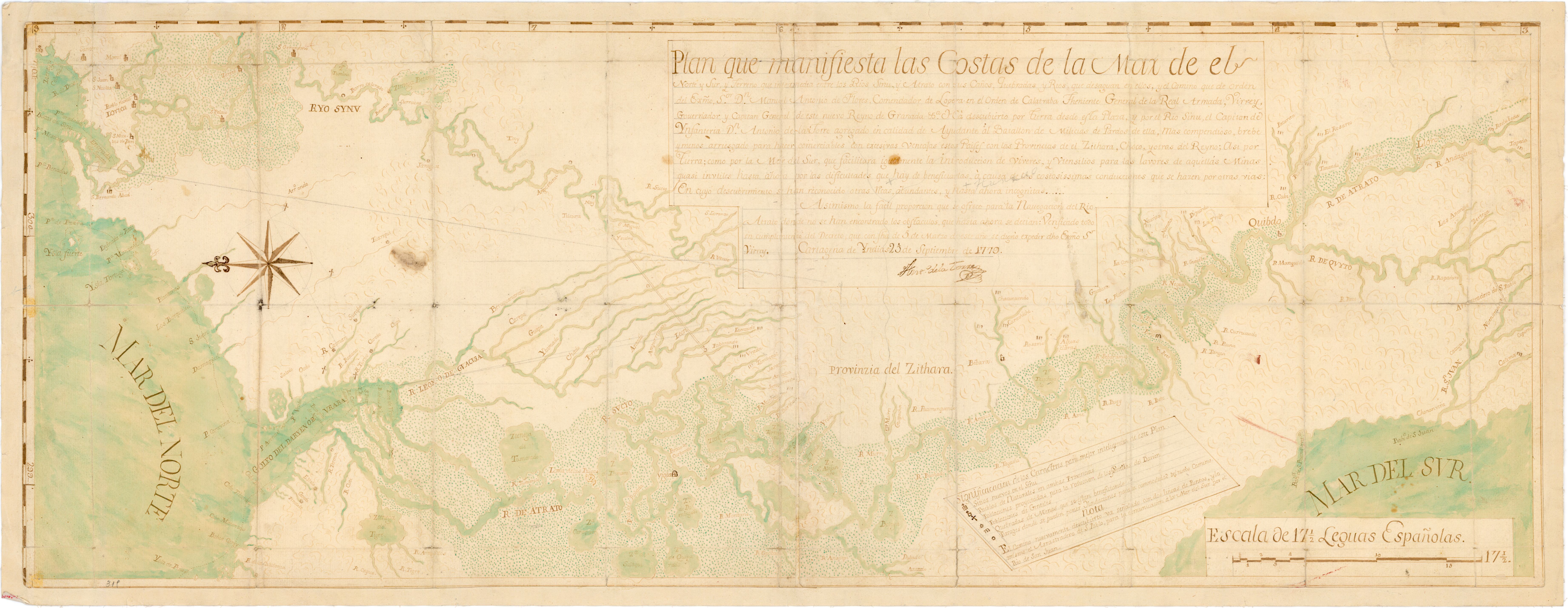
Dispossesions in the Americas

Dispossesions in the Americas

  • Inicio
  • Explorar
  • Autores
  • Sobre
  • Arte
  • Cuerpos
  • Planes de Estudio
  • Herencia Cultural
  • Mapas
  • Territorios
Volver a Explorar

Leyendo en Inglés

Mapa 1794

A New Chart of the Coast of Brazil from the Banks of St. Roque, to the Island of St. Sebastian;with the Islands and Soundings in the Offing

  • WHITTLE, JAMES, ET AL.

Publicado: 1794

  • Descargar Imágen
  • Descargar Imágen
Mapa 1794

A New Chart of the Coast of Brazil from the Banks of St. Roque, to the Island of St. Sebastian;with the Islands and Soundings in the Offing

  • WHITTLE, JAMES, ET AL.

Publicado: 1794

  • Descargar Imágen

Pueblos

  • INDIAN VILLAGE

Citas

Whittle, James, and Robert Laurie. A New Chart of the Coast of Brazil from the Banks of St. Roque, to the Island of St. Sebastian;with the Islands and Soundings in the Offing. Map. London: Laurie & Whittle, 1794. Accessed July 26, 2023. https://gallica.bnf.fr/ark:/12148/btv1b53123069n/f1.item.

  • Descargar Imágen

Artículos Relacionados

San Juan Baptista, San Luys Tezontla y Santa María Nochtongo. Oaxaca, 1579

San Juan Baptista, San Luys Tezontla y Santa María Nochtongo. Oaxaca, 1579

Mapa 1579
Entrée des rivières d'Ouyapoco et de Couripi.

Entrée des rivières d'Ouyapoco et de Couripi.

Mapa 1764
CARTA DEL DEPARTAMENTO DEL ORINOCO O DE MATURIN

CARTA DEL DEPARTAMENTO DEL ORINOCO O DE MATURIN

Mapa 1827
[Carte manuscrite de l'embouchure de Rio da Prata]

[Carte manuscrite de l'embouchure de Rio da Prata]

Mapa 1740
ATLAS de VENEZUELA ESTADO ZULIA

ATLAS de VENEZUELA ESTADO ZULIA

Mapa 1916
XXI. Cours du Rio Guaviare et de la partie de l'Apure comprise entre la ville de San-Fernando et le confluent de l'Apure avec l'Orenoque.

XXI. Cours du Rio Guaviare et de la partie de l'Apure comprise entre la ville de San-Fernando et le confluent de l'Apure avec l'Orenoque.

Mapa 1799 - 1804
Territorios Indigenas en Guatemala 2,001

Territorios Indigenas en Guatemala 2,001

Mapa 2001
Carta Particular de la Costa de Mosquitos;con sus Baxos;Escollos;Canales;Sonadas & c.a.[Material cartogáfico]:Para el Uso Delos Navios de Guerra Yngleses;y de la que sirve el Almirantasgo para su govierno.

Carta Particular de la Costa de Mosquitos;con sus Baxos;Escollos;Canales;Sonadas & c.a.[Material cartogáfico]:Para el Uso Delos Navios de Guerra Yngleses;y de la que sirve el Almirantasgo para su govierno.

Mapa 1764

Despojos en las Américas

Un Proyecto de

University of Pennsylvania

Copyright 2024

Con el apoyo de

Mellon Foundation

Diseño y Desarrollo del Sitio

Element 84

Créditos Artísticos

Whittle, James, and Robert Laurie. A New Chart of the Coast of Brazil from the Banks of St. Roque, to the Island of St. Sebastian;with the Islands and Soundings in the Offing. Map. London: Laurie & Whittle, 1794. Accessed July 26, 2023. https://gallica.bnf.fr/ark:/12148/btv1b53123069n/f1.item.

Páginas del Sitio

  • Inicio
  • Explorar
  • Autores
  • Sobre
  • Arte
  • Cuerpos
  • Planes de Estudio
  • Herencia Cultural
  • Mapas
  • Territorios