Pueblos
- CAPECHENES
- HYPURINAS
Cita
Chandless, William. "Map of the River Aquiry (an Affluent of the Purûs)." Map. 1865. Accessed July 25, 2023. https://gallica.bnf.fr/ark:/12148/btv1b84411818/f1.item.
MAPA 1: RIO ATRATO Y PUEBLOS DE INDIOS CUNA-CUNAS
Mapa 1759
Grupos Indígenas de México
Mapa 2001
CAMINOS DE MIGRACIÓN EN EL MONTE
Mapa 2003
PUEBLO NAHUA DE SAN LUIS POTOSI
Mapa 2020
LA USURPACIÓN DEL TERRITORIO AYOREO EN PARAGUAY
Mapa 1950 - 2009
MAPAS DAS PROVINCIAS ETNOGRÁFICAS NO TERRITÓRIO DO RIO GRANDE DO SUL
Mapa 1500 - 1600
An exact draught of the river of Bellese as high as the Barcadares. A new draught of the bay of Honduras by Capt. Nathaniel Uring
Mapa 1726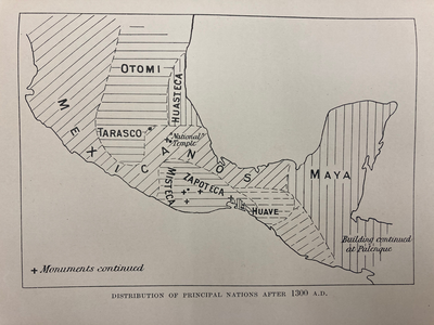
DISTRIBUTION OF PRINCIPAL NATIONS AFTER 1300 AD
Mapa 1300